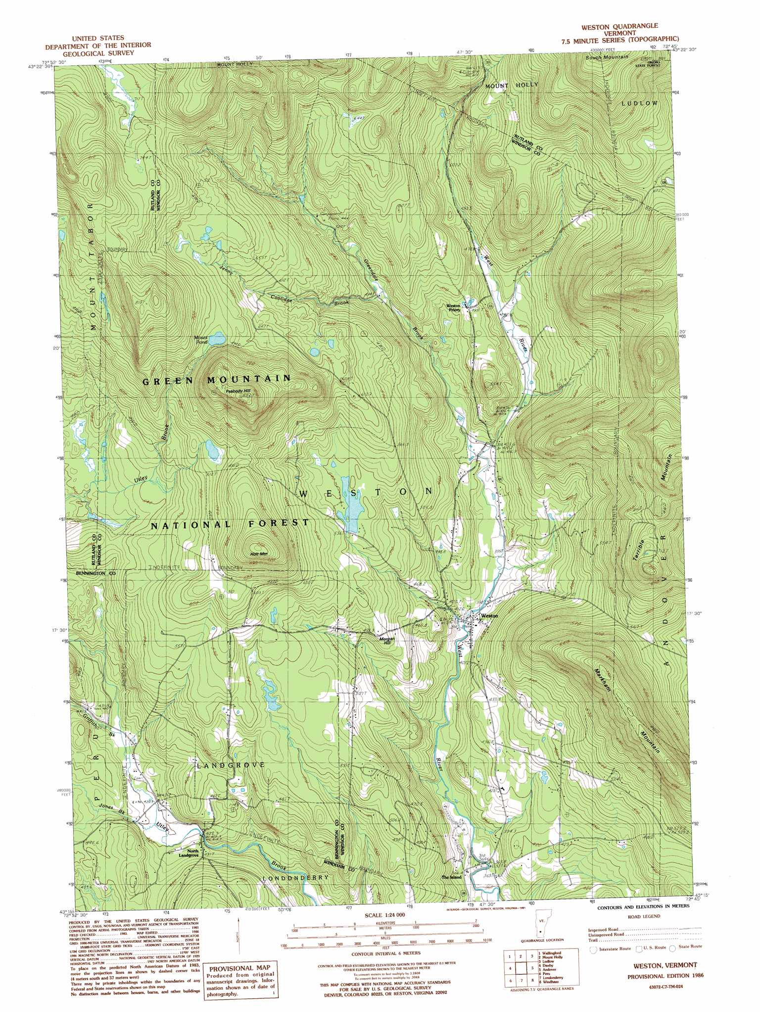
Weston Topo Map Vermont
To zoom in, hover over the map of Weston
USGS Topo Quad 43072c7 - 1:24,000 scale
| Topo Map Name: | Weston |
| USGS Topo Quad ID: | 43072c7 |
| Print Size: | ca. 21 1/4" wide x 27" high |
| Southeast Coordinates: | 43.25° N latitude / 72.75° W longitude |
| Map Center Coordinates: | 43.3125° N latitude / 72.8125° W longitude |
| U.S. State: | VT |
| Filename: | o43072c7.jpg |
| Download Map JPG Image: | Weston topo map 1:24,000 scale |
| Map Type: | Topographic |
| Topo Series: | 7.5´ |
| Map Scale: | 1:24,000 |
| Source of Map Images: | United States Geological Survey (USGS) |
| Alternate Map Versions: |
Weston VT 1986, updated 1987 Download PDF Buy paper map Weston VT 1986, updated 1991 Download PDF Buy paper map Weston VT 1997, updated 2000 Download PDF Buy paper map Weston VT 2012 Download PDF Buy paper map Weston VT 2015 Download PDF Buy paper map |
| FStopo: | US Forest Service topo Weston is available: Download FStopo PDF Download FStopo TIF |
1:24,000 Topo Quads surrounding Weston
West Rutland |
Rutland |
Killington Peak |
Plymouth |
Woodstock South |
Middletown Springs |
Wallingford |
Mount Holly |
Ludlow |
Cavendish |
Dorset |
Danby |
Weston |
Andover |
Chester |
Manchester |
Peru |
Londonderry |
Saxtons River |
|
Sunderland |
Stratton Mountain |
Jamaica |
Westminster West |
> Back to 43072a1 at 1:100,000 scale
> Back to 43072a1 at 1:250,000 scale
> Back to U.S. Topo Maps home
Weston topo map: Gazetteer
Weston: Dams
Wantastiquet Lake Dam elevation 536m 1758′Weston: Lakes
Moses Pond elevation 675m 2214′Peabody Pond elevation 621m 2037′
Weston: Parks
Farrar Park elevation 396m 1299′Weston Village Historic District elevation 395m 1295′
Weston: Populated Places
North Landgrove elevation 428m 1404′The Island elevation 363m 1190′
Weston elevation 396m 1299′
Weston: Post Offices
Weston Post Office elevation 396m 1299′Weston: Reservoirs
Wantastiquet Lake elevation 536m 1758′Weston: Streams
Greendale Brook elevation 413m 1354′Griffith Brook elevation 423m 1387′
Jenny Coolidge Brook elevation 486m 1594′
Jones Brook elevation 417m 1368′
Weston: Summits
Holt Mountain elevation 756m 2480′Markham Mountain elevation 758m 2486′
Morgan Hill elevation 516m 1692′
Peabody Hill elevation 854m 2801′
Weston: Swamps
Beaver Meadows elevation 715m 2345′Weston digital topo map on disk
Buy this Weston topo map showing relief, roads, GPS coordinates and other geographical features, as a high-resolution digital map file on DVD:
New York, Vermont, Connecticut & Western Massachusetts
Buy digital topo maps: New York, Vermont, Connecticut & Western Massachusetts