Mccarthy Ridge Topo Map Oregon
To zoom in, hover over the map of Mccarthy Ridge
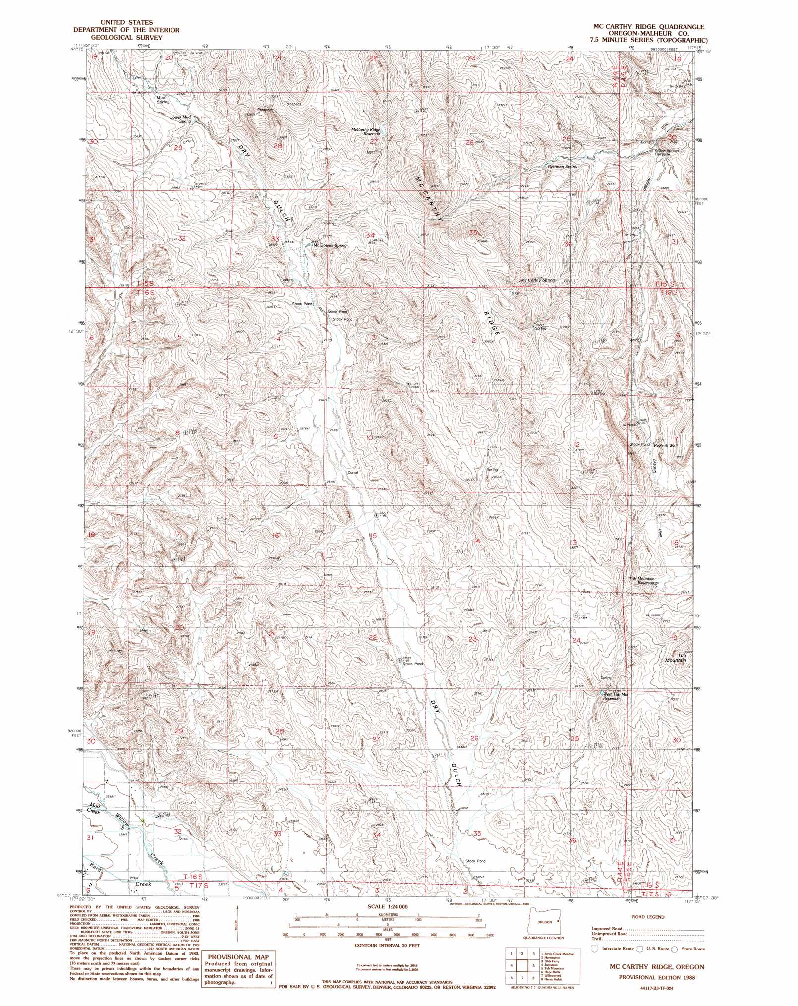
USGS Topo Quad 44117b3 - 1:24,000 scale
| Topo Map Name: | Mccarthy Ridge |
| USGS Topo Quad ID: | 44117b3 |
| Print Size: | ca. 21 1/4" wide x 27" high |
| Southeast Coordinates: | 44.125° N latitude / 117.25° W longitude |
| Map Center Coordinates: | 44.1875° N latitude / 117.3125° W longitude |
| U.S. State: | OR |
| Filename: | o44117b3.jpg |
| Download Map JPG Image: | Mccarthy Ridge topo map 1:24,000 scale |
| Map Type: | Topographic |
| Topo Series: | 7.5´ |
| Map Scale: | 1:24,000 |
| Source of Map Images: | United States Geological Survey (USGS) |
| Alternate Map Versions: |
Mc Carthy Ridge OR 1988, updated 1988 Download PDF Buy paper map McCarthy Ridge OR 2011 Download PDF Buy paper map McCarthy Ridge OR 2014 Download PDF Buy paper map |
1:24,000 Topo Quads surrounding Mccarthy Ridge
Mormon Basin |
Rye Valley |
Lime |
Henley Basin |
Olds Ferry Ne |
Becker Creek |
Birch Creek Meadow |
Huntington |
Olds Ferry |
Porters Flat |
Brogan |
Jamieson |
Mccarthy Ridge |
Tub Mountain |
Moores Hollow |
Swede Flat |
Hope Butte |
Willow Creek |
Henry Gulch |
Malheur Butte |
Little Valley |
Vines Hill |
Vale West |
Vale East |
Cairo |
> Back to 44117a1 at 1:100,000 scale
> Back to 44116a1 at 1:250,000 scale
> Back to U.S. Topo Maps home
Mccarthy Ridge topo map: Gazetteer
Mccarthy Ridge: Reservoirs
Dry Gulch Reservoir (historical) elevation 815m 2673′McCarthy Ridge Reservoir elevation 900m 2952′
Tub Mountain Reservoir elevation 855m 2805′
West Tub Mountain Reservoir elevation 792m 2598′
Mccarthy Ridge: Ridges
McCarthy Ridge elevation 1047m 3435′Mccarthy Ridge: Springs
Beirman Spring elevation 778m 2552′Lower Mud Spring elevation 861m 2824′
McCarthy Spring elevation 839m 2752′
McDowell Spring elevation 822m 2696′
Mud Spring elevation 874m 2867′
Mccarthy Ridge: Streams
Kern Creek elevation 726m 2381′Mud Creek elevation 729m 2391′
Mccarthy Ridge: Wells
Redsull Well elevation 829m 2719′Mccarthy Ridge digital topo map on disk
Buy this Mccarthy Ridge topo map showing relief, roads, GPS coordinates and other geographical features, as a high-resolution digital map file on DVD: