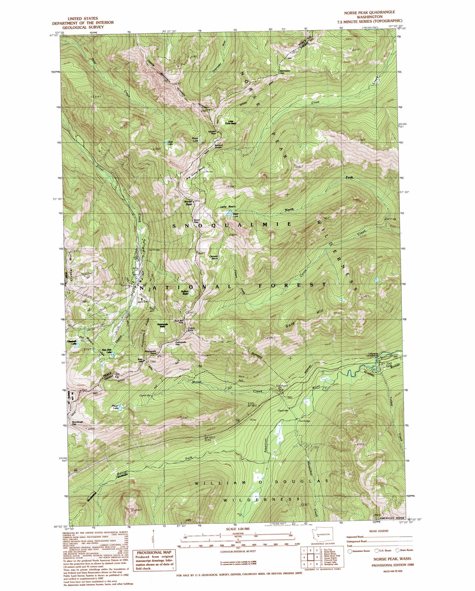
Norse Peak Topo Map Washington
To zoom in, hover over the map of Norse Peak
USGS Topo Quad 46121h4 - 1:24,000 scale
| Topo Map Name: | Norse Peak |
| USGS Topo Quad ID: | 46121h4 |
| Print Size: | ca. 21 1/4" wide x 27" high |
| Southeast Coordinates: | 46.875° N latitude / 121.375° W longitude |
| Map Center Coordinates: | 46.9375° N latitude / 121.4375° W longitude |
| U.S. State: | WA |
| Filename: | o46121h4.jpg |
| Download Map JPG Image: | Norse Peak topo map 1:24,000 scale |
| Map Type: | Topographic |
| Topo Series: | 7.5´ |
| Map Scale: | 1:24,000 |
| Source of Map Images: | United States Geological Survey (USGS) |
| Alternate Map Versions: |
Norse Peak WA 1988, updated 1988 Download PDF Buy paper map Norse Peak WA 1988, updated 1988 Download PDF Buy paper map Norse Peak WA 2000, updated 2001 Download PDF Buy paper map Norse Peak WA 2011 Download PDF Buy paper map Norse Peak WA 2014 Download PDF Buy paper map |
| FStopo: | US Forest Service topo Norse Peak is available: Download FStopo PDF Download FStopo TIF |
1:24,000 Topo Quads surrounding Norse Peak
Greenwater |
Nagrom |
Lester |
Blowout Mountain |
Easton |
Clear West Peak |
Sun Top |
Noble Knob |
Raven Roost |
Mount Clifty |
Sunrise |
White River Park |
Norse Peak |
Goose Prairie |
Old Scab Mountain |
Mt Rainier East |
Chinook Pass |
Cougar Lake |
Bumping Lake |
Timberwolf Mountain |
Tatoosh Lakes |
Ohanapecosh Hot Springs |
White Pass |
Spiral Butte |
Rimrock Lake |
> Back to 46121e1 at 1:100,000 scale
> Back to 46120a1 at 1:250,000 scale
> Back to U.S. Topo Maps home
Norse Peak topo map: Gazetteer
Norse Peak: Areas
Crystal Mountain Area elevation 1456m 4776′Norse Peak: Basins
Big Crow Basin elevation 1882m 6174′Bullion Basin elevation 1779m 5836′
Cement Basin elevation 1894m 6213′
Lake Basin elevation 1826m 5990′
Little Crow Basin elevation 1696m 5564′
Pickhandle Basin elevation 1643m 5390′
Norse Peak: Dams
Placer Lake Dam elevation 1640m 5380′Norse Peak: Gaps
Barnard Saddle elevation 1802m 5912′Bear Gap elevation 1834m 6017′
Blue Bell Pass elevation 1830m 6003′
Hayden Pass elevation 1823m 5980′
Martinson Gap elevation 1754m 5754′
Pickhandle Gap elevation 1793m 5882′
Scout Pass elevation 1942m 6371′
Norse Peak: Lakes
Basin Lake elevation 1780m 5839′Elizabeth Lake elevation 1780m 5839′
Goat Lake elevation 1687m 5534′
Hen Skin Lake elevation 1670m 5479′
Miners Lakes elevation 1707m 5600′
Reese Lake elevation 1756m 5761′
Norse Peak: Reservoirs
Placer Lake elevation 1640m 5380′Norse Peak: Streams
Cement Creek elevation 1460m 4790′Elizabeth Creek elevation 1340m 4396′
Mesatchee Creek elevation 1101m 3612′
Morse Creek elevation 1102m 3615′
North Fork Union Creek elevation 1220m 4002′
Rainier Fork American River elevation 1110m 3641′
Timber Creek elevation 1088m 3569′
Norse Peak: Summits
Castle Mountain elevation 1897m 6223′Crown Point elevation 1937m 6354′
Gold Hill elevation 1875m 6151′
Norse Peak elevation 2068m 6784′
Pickhandle Point elevation 1917m 6289′
Norse Peak: Trails
Castle Mountain Trail elevation 1799m 5902′Union Creek Trail elevation 1315m 4314′
Norse Peak digital topo map on disk
Buy this Norse Peak topo map showing relief, roads, GPS coordinates and other geographical features, as a high-resolution digital map file on DVD: