Union Topo Map Washington
To zoom in, hover over the map of Union
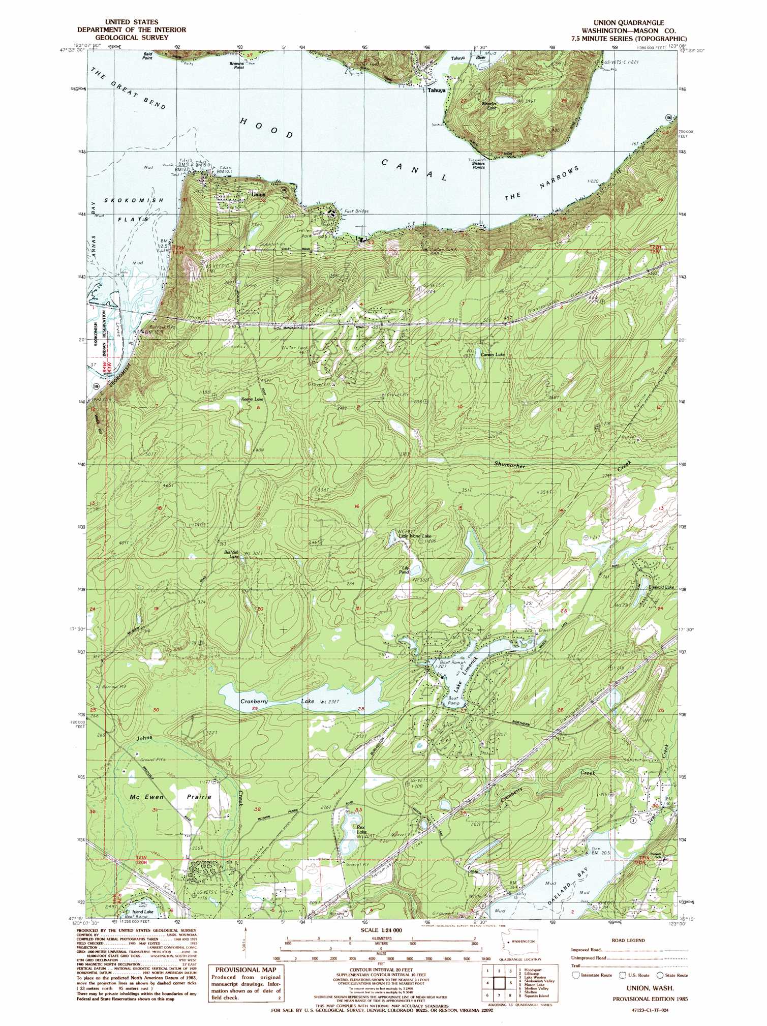
USGS Topo Quad 47123c1 - 1:24,000 scale
| Topo Map Name: | Union |
| USGS Topo Quad ID: | 47123c1 |
| Print Size: | ca. 21 1/4" wide x 27" high |
| Southeast Coordinates: | 47.25° N latitude / 123° W longitude |
| Map Center Coordinates: | 47.3125° N latitude / 123.0625° W longitude |
| U.S. State: | WA |
| Filename: | o47123c1.jpg |
| Download Map JPG Image: | Union topo map 1:24,000 scale |
| Map Type: | Topographic |
| Topo Series: | 7.5´ |
| Map Scale: | 1:24,000 |
| Source of Map Images: | United States Geological Survey (USGS) |
| Alternate Map Versions: |
Union WA 1985, updated 1985 Download PDF Buy paper map Union WA 2011 Download PDF Buy paper map Union WA 2014 Download PDF Buy paper map |
1:24,000 Topo Quads surrounding Union
Mount Skokomish |
Mount Washington |
Eldon |
Holly |
Wildcat Lake |
Lightning Peak |
Hoodsport |
Lilliwaup |
Lake Wooten |
Belfair |
Vance Creek |
Skokomish Valley |
Union |
Mason Lake |
Vaughn |
Nahwatzel Lake |
Shelton Valley |
Shelton |
Squaxin Island |
Longbranch |
Mccleary |
Kamilche Valley |
Summit Lake |
Olympia |
Lacey |
> Back to 47123a1 at 1:100,000 scale
> Back to 47122a1 at 1:250,000 scale
> Back to U.S. Topo Maps home
Union topo map: Gazetteer
Union: Bends
The Great Bend elevation 0m 0′Union: Capes
Ayres Point elevation 7m 22′Sisters Points elevation 2m 6′
Union: Dams
Lake Leprechaun Dam elevation 80m 262′Lake Limerick Dam elevation 68m 223′
Rosand Dam elevation 66m 216′
Union: Flats
McEwen Prairie elevation 72m 236′Skokomish Flats elevation 0m 0′
Union: Guts
The Narrows elevation -47m -155′Union: Lakes
Bathtub Lake elevation 101m 331′Carson Lake elevation 131m 429′
Cranberry Lake elevation 73m 239′
Deepwater Lake elevation 96m 314′
Emerald Lake elevation 72m 236′
Keene Lake elevation 121m 396′
Lake Leprechaun elevation 74m 242′
Lake Limerick elevation 68m 223′
Lily Pond elevation 93m 305′
Little Island Lake elevation 93m 305′
Rainbow Lake elevation 56m 183′
Rex Lake elevation 66m 216′
Wheeler Lake elevation 108m 354′
Union: Populated Places
Tahuya elevation 6m 19′Union elevation 46m 150′
Union: Reservoirs
Lake Leprechaun elevation 80m 262′Lake Limerick elevation 68m 223′
Union: Ridges
Webb Hill elevation 145m 475′Union: Streams
Cranberry Creek elevation 3m 9′Deer Creek elevation 3m 9′
Malaney Creek elevation 1m 3′
Skokomish River elevation 2m 6′
Tahuya River elevation 0m 0′
Union: Valleys
Skokomish Valley elevation 2m 6′Union digital topo map on disk
Buy this Union topo map showing relief, roads, GPS coordinates and other geographical features, as a high-resolution digital map file on DVD: