Mccleary Topo Map Washington
To zoom in, hover over the map of Mccleary
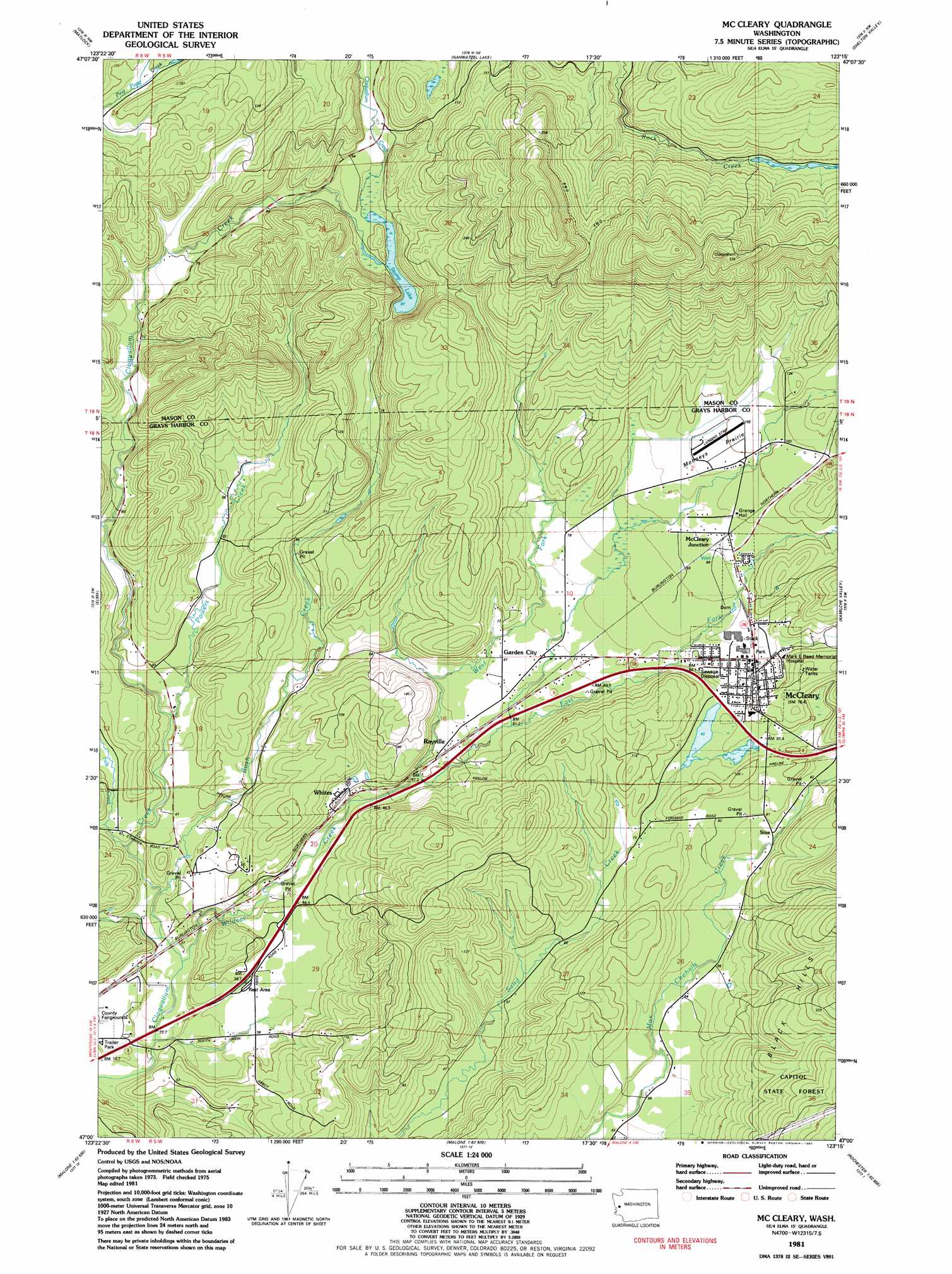
USGS Topo Quad 47123a3 - 1:24,000 scale
| Topo Map Name: | Mccleary |
| USGS Topo Quad ID: | 47123a3 |
| Print Size: | ca. 21 1/4" wide x 27" high |
| Southeast Coordinates: | 47° N latitude / 123.25° W longitude |
| Map Center Coordinates: | 47.0625° N latitude / 123.3125° W longitude |
| U.S. State: | WA |
| Filename: | o47123a3.jpg |
| Download Map JPG Image: | Mccleary topo map 1:24,000 scale |
| Map Type: | Topographic |
| Topo Series: | 7.5´ |
| Map Scale: | 1:24,000 |
| Source of Map Images: | United States Geological Survey (USGS) |
| Alternate Map Versions: |
Mc Cleary WA 1981, updated 1981 Download PDF Buy paper map McCleary WA 2011 Download PDF Buy paper map McCleary WA 2014 Download PDF Buy paper map |
1:24,000 Topo Quads surrounding Mccleary
Grisdale |
Dry Bed Lakes |
Vance Creek |
Skokomish Valley |
Union |
Wynoochee Valley Ne |
Matlock |
Nahwatzel Lake |
Shelton Valley |
Shelton |
Prices Peak |
Elma |
Mccleary |
Kamilche Valley |
Summit Lake |
Montesano |
South Elma |
Malone |
Capitol Peak |
Little Rock |
Brooklyn |
Blue Mountain |
Cedarville |
Oakville |
Rochester |
> Back to 47123a1 at 1:100,000 scale
> Back to 47122a1 at 1:250,000 scale
> Back to U.S. Topo Maps home
Mccleary topo map: Gazetteer
Mccleary: Airports
Bear Valley Skyranch Airport elevation 100m 328′Mark Reed Hospital Heliport elevation 91m 298′
Mccleary: Flats
Mohneys Prairie elevation 99m 324′Mccleary: Lakes
Stump Lake elevation 88m 288′Mccleary: Populated Places
Garden City elevation 67m 219′Hillgrove elevation 91m 298′
McCleary elevation 84m 275′
McCleary Junction elevation 90m 295′
Rayville elevation 53m 173′
Sine elevation 79m 259′
Mccleary: Streams
Bush Creek elevation 26m 85′East Fork Wildcat Creek elevation 46m 150′
Falls Creek elevation 38m 124′
Powers Creek elevation 40m 131′
Raccoon Run elevation 73m 239′
West Fork Wildcat Creek elevation 47m 154′
Wildcat Creek elevation 23m 75′
Mccleary: Trails
Cloquallum Truck Trail elevation 172m 564′Mccleary digital topo map on disk
Buy this Mccleary topo map showing relief, roads, GPS coordinates and other geographical features, as a high-resolution digital map file on DVD: