Flag Mountain Topo Map Alabama
To zoom in, hover over the map of Flag Mountain
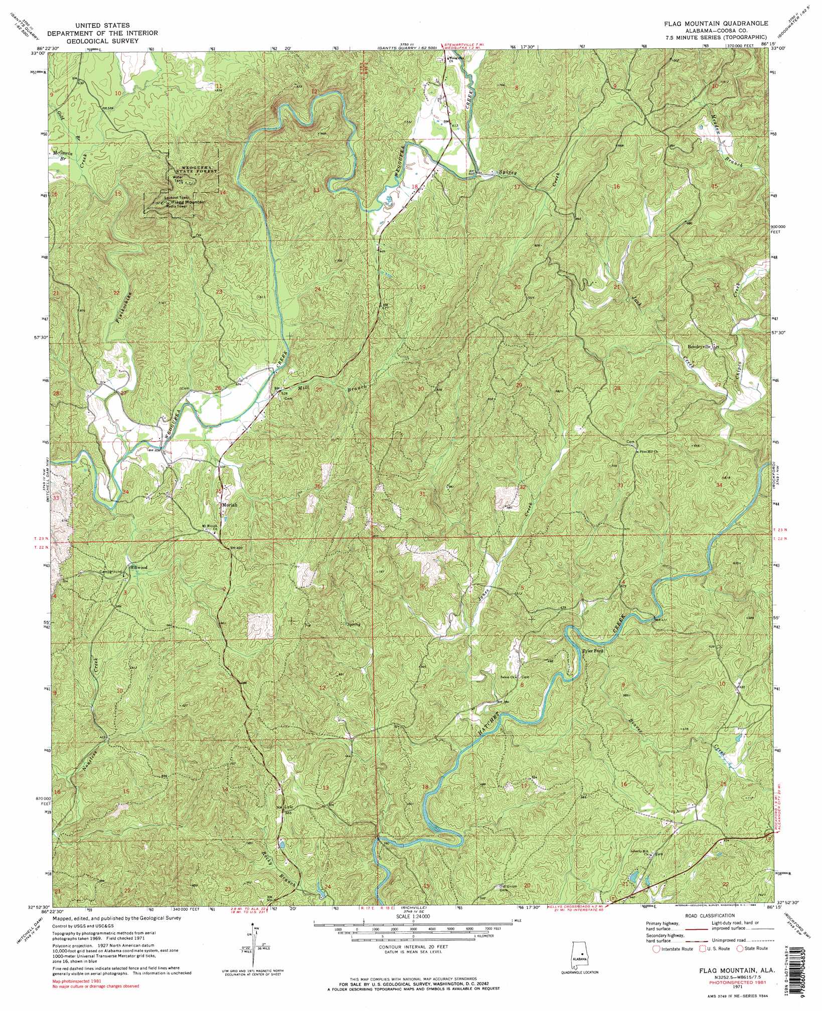
USGS Topo Quad 32086h3 - 1:24,000 scale
| Topo Map Name: | Flag Mountain |
| USGS Topo Quad ID: | 32086h3 |
| Print Size: | ca. 21 1/4" wide x 27" high |
| Southeast Coordinates: | 32.875° N latitude / 86.25° W longitude |
| Map Center Coordinates: | 32.9375° N latitude / 86.3125° W longitude |
| U.S. State: | AL |
| Filename: | o32086h3.jpg |
| Download Map JPG Image: | Flag Mountain topo map 1:24,000 scale |
| Map Type: | Topographic |
| Topo Series: | 7.5´ |
| Map Scale: | 1:24,000 |
| Source of Map Images: | United States Geological Survey (USGS) |
| Alternate Map Versions: |
Flag Mountain AL 1971, updated 1973 Download PDF Buy paper map Flag Mountain AL 1971, updated 1984 Download PDF Buy paper map Flag Mountain AL 2011 Download PDF Buy paper map Flag Mountain AL 2014 Download PDF Buy paper map |
1:24,000 Topo Quads surrounding Flag Mountain
Columbiana |
Wilsonville |
Sylacauga West |
Sylacauga East |
Bulls Gap |
Shelby |
Talladega Springs |
Weogufka |
Hollins |
Goodwater |
Lay Dam |
Mitchell Dam Nw |
Flag Mountain |
Rockford |
Kellyton |
Clanton East |
Mitchell Dam |
Richville |
Rockford Sw |
Equality |
White City |
Marbury |
Holtville |
Dexter |
Eclectic |
> Back to 32086e1 at 1:100,000 scale
> Back to 32086a1 at 1:250,000 scale
> Back to U.S. Topo Maps home
Flag Mountain topo map: Gazetteer
Flag Mountain: Crossings
Island Ford elevation 181m 593′Scott Ford elevation 120m 393′
Tyler Ford elevation 113m 370′
Flag Mountain: Forests
Weogufka State Forest elevation 291m 954′Flag Mountain: Mines
Cowart Number One Mine elevation 172m 564′Cowart Number Two Mine elevation 164m 538′
Hatchet Vent Mine elevation 160m 524′
Pond Mine elevation 169m 554′
Seminole Mine elevation 225m 738′
Flag Mountain: Populated Places
Bentleyville elevation 161m 528′Hillwood elevation 159m 521′
Lyle elevation 171m 561′
Moriah elevation 184m 603′
Weogufka (historical) elevation 152m 498′
Flag Mountain: Ranges
Weogufka Mountains elevation 188m 616′Flag Mountain: Streams
Beaver Creek elevation 116m 380′Chipco Creek elevation 120m 393′
Finikochika Creek elevation 149m 488′
Gold Branch elevation 172m 564′
Jack Creek elevation 128m 419′
Jones Creek elevation 113m 370′
McCutchen Branch elevation 177m 580′
McGowin Branch elevation 172m 564′
Mill Branch elevation 157m 515′
Mill Creek elevation 187m 613′
Spivey Creek elevation 184m 603′
Flag Mountain: Summits
Flag Mountain elevation 350m 1148′Flag Mountain digital topo map on disk
Buy this Flag Mountain topo map showing relief, roads, GPS coordinates and other geographical features, as a high-resolution digital map file on DVD:
Gulf Coast (LA, MS, AL, FL) & Southwestern Georgia
Buy digital topo maps: Gulf Coast (LA, MS, AL, FL) & Southwestern Georgia
 & Southwestern Georgia map DVD")