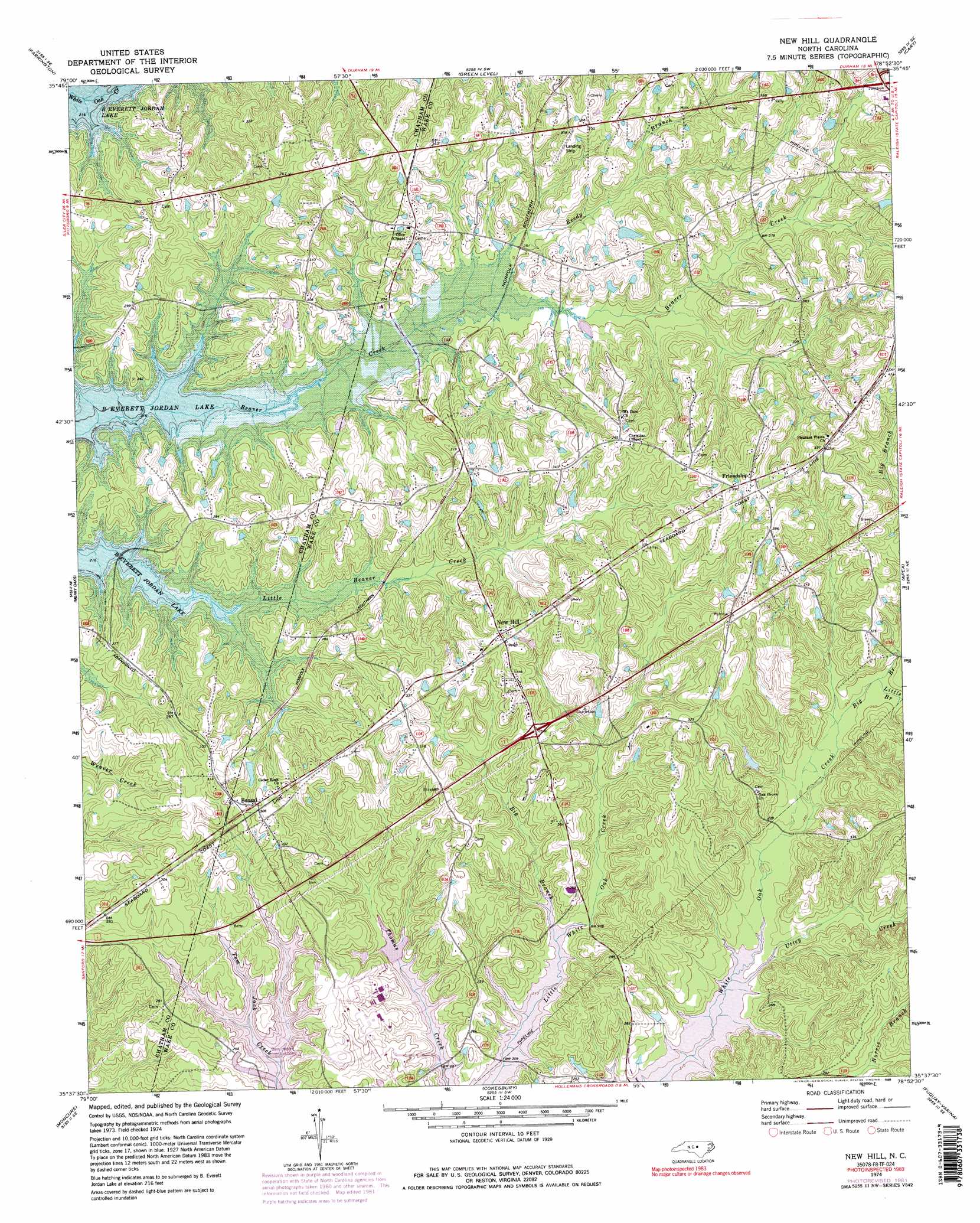
New Hill Topo Map North Carolina
To zoom in, hover over the map of New Hill
USGS Topo Quad 35078f8 - 1:24,000 scale
| Topo Map Name: | New Hill |
| USGS Topo Quad ID: | 35078f8 |
| Print Size: | ca. 21 1/4" wide x 27" high |
| Southeast Coordinates: | 35.625° N latitude / 78.875° W longitude |
| Map Center Coordinates: | 35.6875° N latitude / 78.9375° W longitude |
| U.S. State: | NC |
| Filename: | o35078f8.jpg |
| Download Map JPG Image: | New Hill topo map 1:24,000 scale |
| Map Type: | Topographic |
| Topo Series: | 7.5´ |
| Map Scale: | 1:24,000 |
| Source of Map Images: | United States Geological Survey (USGS) |
| Alternate Map Versions: |
New Hill NC 1974, updated 1977 Download PDF Buy paper map New Hill NC 1974, updated 1982 Download PDF Buy paper map New Hill NC 1974, updated 1989 Download PDF Buy paper map New Hill NC 1974, updated 1989 Download PDF Buy paper map New Hill NC 1993, updated 1999 Download PDF Buy paper map New Hill NC 2002, updated 2004 Download PDF Buy paper map New Hill NC 2010 Download PDF Buy paper map New Hill NC 2013 Download PDF Buy paper map New Hill NC 2016 Download PDF Buy paper map |
1:24,000 Topo Quads surrounding New Hill
White Cross |
Chapel Hill |
Southwest Durham |
Southeast Durham |
Bayleaf |
Bynum |
Farrington |
Green Level |
Cary |
Raleigh West |
Pittsboro |
Merry Oaks |
New Hill |
Apex |
Lake Wheeler |
Colon |
Moncure |
Cokesbury |
Fuquay-Varina |
Angier |
Sanford |
Broadway |
Mamers |
Lillington |
Coats |
> Back to 35078e1 at 1:100,000 scale
> Back to 35078a1 at 1:250,000 scale
> Back to U.S. Topo Maps home
New Hill topo map: Gazetteer
New Hill: Airports
Deck Airpark elevation 98m 321′New Hill: Dams
Gerringer-Goodman Dam elevation 103m 337′New Hill: Populated Places
Bonsal elevation 91m 298′Friendship elevation 118m 387′
New Hill elevation 104m 341′
New Hill: Reservoirs
Gerringer-Goodman Pond elevation 103m 337′New Hill: Streams
Big Branch elevation 74m 242′Big Branch elevation 67m 219′
Little Branch elevation 75m 246′
Reedy Branch elevation 71m 232′
Utley Creek elevation 67m 219′
New Hill digital topo map on disk
Buy this New Hill topo map showing relief, roads, GPS coordinates and other geographical features, as a high-resolution digital map file on DVD:
South Carolina, Western North Carolina & Northeastern Georgia
Buy digital topo maps: South Carolina, Western North Carolina & Northeastern Georgia