Southwest Durham Topo Map North Carolina
To zoom in, hover over the map of Southwest Durham
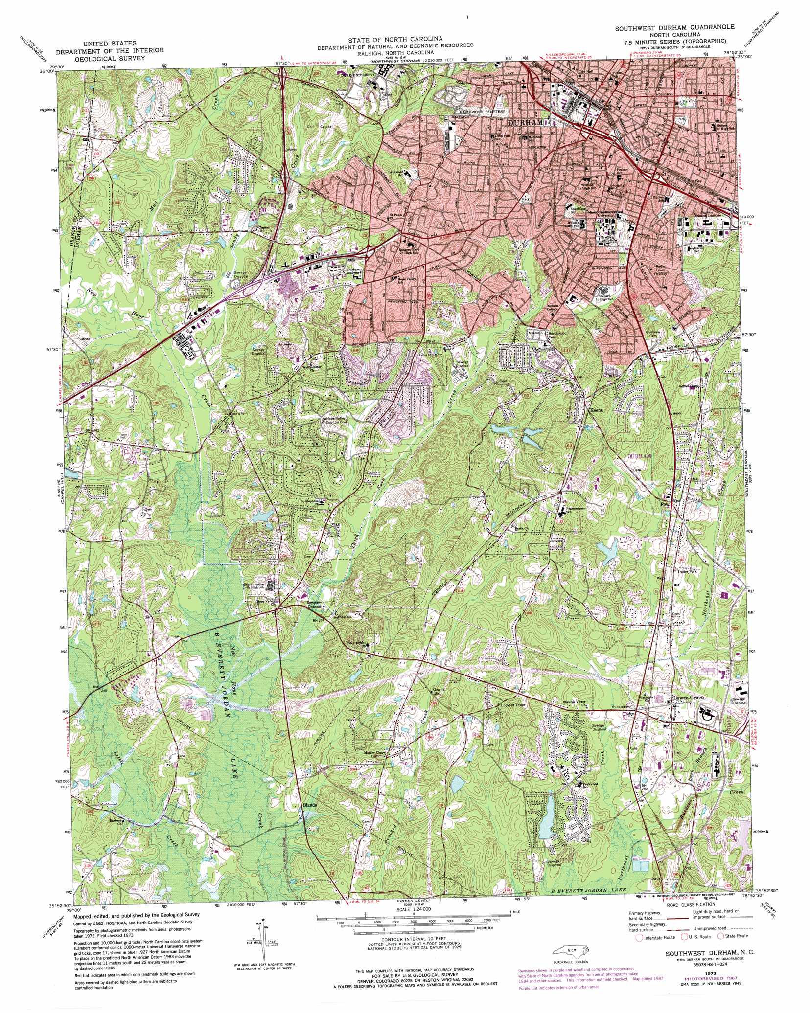
USGS Topo Quad 35078h8 - 1:24,000 scale
| Topo Map Name: | Southwest Durham |
| USGS Topo Quad ID: | 35078h8 |
| Print Size: | ca. 21 1/4" wide x 27" high |
| Southeast Coordinates: | 35.875° N latitude / 78.875° W longitude |
| Map Center Coordinates: | 35.9375° N latitude / 78.9375° W longitude |
| U.S. State: | NC |
| Filename: | o35078h8.jpg |
| Download Map JPG Image: | Southwest Durham topo map 1:24,000 scale |
| Map Type: | Topographic |
| Topo Series: | 7.5´ |
| Map Scale: | 1:24,000 |
| Source of Map Images: | United States Geological Survey (USGS) |
| Alternate Map Versions: |
Southwest Durham NC 1973, updated 1977 Download PDF Buy paper map Southwest Durham NC 1973, updated 1983 Download PDF Buy paper map Southwest Durham NC 1973, updated 1987 Download PDF Buy paper map Southwest Durham NC 1973, updated 1987 Download PDF Buy paper map Southwest Durham NC 1993, updated 1998 Download PDF Buy paper map Southwest Durham NC 2010 Download PDF Buy paper map Southwest Durham NC 2013 Download PDF Buy paper map Southwest Durham NC 2016 Download PDF Buy paper map |
1:24,000 Topo Quads surrounding Southwest Durham
Cedar Grove |
Caldwell |
Rougemont |
Lake Michie |
Stem |
Efland |
Hillsborough |
Northwest Durham |
Northeast Durham |
Creedmoor |
White Cross |
Chapel Hill |
Southwest Durham |
Southeast Durham |
Bayleaf |
Bynum |
Farrington |
Green Level |
Cary |
Raleigh West |
Pittsboro |
Merry Oaks |
New Hill |
Apex |
Lake Wheeler |
> Back to 35078e1 at 1:100,000 scale
> Back to 35078a1 at 1:250,000 scale
> Back to U.S. Topo Maps home
Southwest Durham topo map: Gazetteer
Southwest Durham: Crossings
Interchange 270 elevation 98m 321′Interchange 273A and 273B elevation 89m 291′
Interchange 274 elevation 84m 275′
Interchange 276 elevation 101m 331′
Interchange 278 elevation 93m 305′
Interchange 279A and 279B elevation 87m 285′
Southwest Durham: Dams
Clark Lake Dam elevation 86m 282′Few Lake Dam elevation 84m 275′
Frazier Lake Dam elevation 83m 272′
Lake Elton Dam elevation 91m 298′
Matthews Lake Dam elevation 83m 272′
Niehs Research Triangle Park Dam elevation 81m 265′
Parkwood Lake Dam elevation 78m 255′
Roycroft Lake Dam elevation 93m 305′
Straford Lake Number One Dam elevation 95m 311′
Straford Lake Number Two Dam elevation 93m 305′
Southwest Durham: Parks
O'Kelly-Riddick Stadium elevation 100m 328′Wallace Wade Stadium elevation 103m 337′
Southwest Durham: Populated Places
Blands elevation 72m 236′Chicopee Hills elevation 78m 255′
Colony Park elevation 99m 324′
Devonshire Manor elevation 91m 298′
Durham elevation 122m 400′
Eastwood Park elevation 78m 255′
Falconbridge elevation 86m 282′
Few elevation 96m 314′
Five Oaks elevation 92m 301′
Hickory Oaks elevation 86m 282′
Hope Valley North elevation 101m 331′
Hope Valley West elevation 105m 344′
Keene elevation 113m 370′
Lochnora elevation 100m 328′
Lowes Grove elevation 95m 311′
Marydell elevation 92m 301′
New Hope Valley elevation 84m 275′
Parkwood elevation 86m 282′
Surry Green elevation 84m 275′
The Downs elevation 89m 291′
Woodberry elevation 75m 246′
Woodcroft elevation 74m 242′
Southwest Durham: Post Offices
Durham Post Office elevation 123m 403′Southwest Durham: Reservoirs
Clark Lake elevation 86m 282′Few Lake elevation 84m 275′
Frazier Lake elevation 83m 272′
Lake Elton elevation 91m 298′
Matthews Lake elevation 83m 272′
Noname elevation 81m 265′
Parkwood Lake elevation 78m 255′
Roycroft Lake elevation 93m 305′
Straford Lake Number One elevation 95m 311′
Straford Lake Number Two elevation 93m 305′
Southwest Durham: Streams
Buck Branch elevation 77m 252′Burdens Creek elevation 74m 242′
Mud Creek elevation 76m 249′
Sandy Creek elevation 75m 246′
Third Fork Creek elevation 69m 226′
Southwest Durham digital topo map on disk
Buy this Southwest Durham topo map showing relief, roads, GPS coordinates and other geographical features, as a high-resolution digital map file on DVD:
South Carolina, Western North Carolina & Northeastern Georgia
Buy digital topo maps: South Carolina, Western North Carolina & Northeastern Georgia