Raleigh West Topo Map North Carolina
To zoom in, hover over the map of Raleigh West
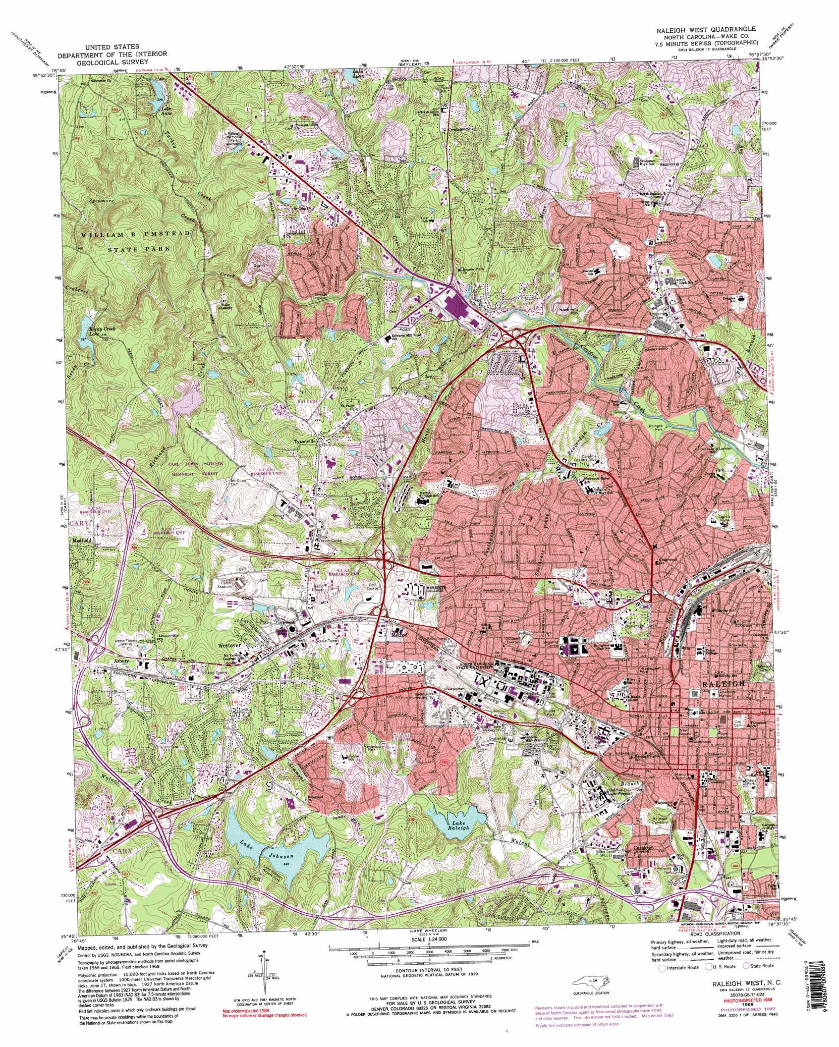
USGS Topo Quad 35078g6 - 1:24,000 scale
| Topo Map Name: | Raleigh West |
| USGS Topo Quad ID: | 35078g6 |
| Print Size: | ca. 21 1/4" wide x 27" high |
| Southeast Coordinates: | 35.75° N latitude / 78.625° W longitude |
| Map Center Coordinates: | 35.8125° N latitude / 78.6875° W longitude |
| U.S. State: | NC |
| Filename: | o35078g6.jpg |
| Download Map JPG Image: | Raleigh West topo map 1:24,000 scale |
| Map Type: | Topographic |
| Topo Series: | 7.5´ |
| Map Scale: | 1:24,000 |
| Source of Map Images: | United States Geological Survey (USGS) |
| Alternate Map Versions: |
Raleigh West NC 1968, updated 1972 Download PDF Buy paper map Raleigh West NC 1968, updated 1976 Download PDF Buy paper map Raleigh West NC 1968, updated 1982 Download PDF Buy paper map Raleigh West NC 1968, updated 1987 Download PDF Buy paper map Raleigh West NC 1968, updated 1991 Download PDF Buy paper map Raleigh West NC 1968, updated 1991 Download PDF Buy paper map Raleigh West NC 1993, updated 1999 Download PDF Buy paper map Raleigh West NC 2002, updated 2004 Download PDF Buy paper map Raleigh West NC 2010 Download PDF Buy paper map Raleigh West NC 2013 Download PDF Buy paper map Raleigh West NC 2016 Download PDF Buy paper map |
1:24,000 Topo Quads surrounding Raleigh West
Northwest Durham |
Northeast Durham |
Creedmoor |
Grissom |
Franklinton |
Southwest Durham |
Southeast Durham |
Bayleaf |
Wake Forest |
Rolesville |
Green Level |
Cary |
Raleigh West |
Raleigh East |
Knightdale |
New Hill |
Apex |
Lake Wheeler |
Garner |
Clayton |
Cokesbury |
Fuquay-Varina |
Angier |
Edmondson |
Powhatan |
> Back to 35078e1 at 1:100,000 scale
> Back to 35078a1 at 1:250,000 scale
> Back to U.S. Topo Maps home
Raleigh West topo map: Gazetteer
Raleigh West: Airports
Administration Building Helispot Airport elevation 101m 331′Raleigh West: Crossings
Interchange 1A elevation 117m 383′Interchange 1B elevation 133m 436′
Interchange 1C elevation 112m 367′
Interchange 1D elevation 127m 416′
Interchange 289 elevation 122m 400′
Interchange 290 elevation 133m 436′
Interchange 291 elevation 131m 429′
Interchange 293A elevation 131m 429′
Interchange 293B elevation 120m 393′
Interchange 295 elevation 124m 406′
Interchange 297 elevation 81m 265′
Interchange 298A and 298B elevation 79m 259′
Interchange 299 elevation 70m 229′
Interchange 2A elevation 113m 370′
Interchange 2B elevation 119m 390′
Interchange 3 elevation 139m 456′
Interchange 4A elevation 123m 403′
Interchange 4B elevation 123m 403′
Interchange 5 elevation 104m 341′
Interchange 6 elevation 88m 288′
Interchange 7 elevation 75m 246′
Interchange 8A elevation 95m 311′
Interchange 8B elevation 105m 344′
Raleigh West: Dams
Dam Number Eleven A Crabtree Creek Watershed elevation 112m 367′Dam Number Thirteen Crabtree Creek Watershed elevation 75m 246′
Dam Number Twenty-Two B Crabtree Creek Watershed elevation 117m 383′
Lake Anne Dam elevation 101m 331′
Lake Johnson Dam elevation 80m 262′
Lake Raleigh Dam elevation 80m 262′
Lakemont Dam elevation 95m 311′
Reedy Creek Lake Dam elevation 79m 259′
Raleigh West: Lakes
Lake Lynn elevation 101m 331′Lake Raleigh elevation 82m 269′
Raleigh West: Parks
Carl Alwin Schenck Memorial Forest elevation 116m 380′Carter Stadium elevation 117m 383′
Chavis Park elevation 89m 291′
Court of North Carolina elevation 116m 380′
Doak Field elevation 120m 393′
Kaplan Park elevation 127m 416′
Kentwood Park elevation 102m 334′
Lake Johnson Nature Park elevation 112m 367′
Lee Field elevation 120m 393′
McIver Amphitheater elevation 127m 416′
Miller Fields elevation 111m 364′
Moore Square elevation 100m 328′
Nash Square elevation 101m 331′
North Hills Park elevation 95m 311′
Paul Derr Track elevation 102m 334′
Powell Drive Park elevation 132m 433′
Pullen Park elevation 108m 354′
Rothgeb Park elevation 62m 203′
Spangler Garden elevation 139m 456′
University Plaza elevation 121m 396′
William B Umstead State Park elevation 85m 278′
Raleigh West: Populated Places
Anderson Heights elevation 93m 305′Asbury elevation 149m 488′
Ashley Park elevation 124m 406′
Beckana elevation 79m 259′
Bellevue Terrace elevation 99m 324′
Birchwood Hills Estates elevation 93m 305′
Boylan Heights elevation 104m 341′
Brandermill elevation 101m 331′
Briarcliff elevation 112m 367′
Brookhaven elevation 128m 419′
Budleigh elevation 102m 334′
Cameron Park elevation 110m 360′
Candero elevation 118m 387′
Caraleigh elevation 90m 295′
Cedar Hills Estates elevation 110m 360′
Chestnut Hills elevation 104m 341′
Chippenhaven Square elevation 118m 387′
Coley Forest elevation 114m 374′
Coley Lakes elevation 106m 347′
Country Club Hills elevation 80m 262′
Country Club Houses elevation 119m 390′
Country Life Estates elevation 111m 364′
Deblyn Park elevation 83m 272′
Drewry Hills elevation 80m 262′
Eden Forest elevation 128m 419′
Edencroft elevation 115m 377′
Edgewood elevation 102m 334′
Fairfax Hills elevation 107m 351′
Fairmont elevation 130m 426′
Fairview Acres elevation 133m 436′
Fairview Hills elevation 122m 400′
Farrior Hills elevation 104m 341′
Georgetown elevation 89m 291′
Glen Eden elevation 115m 377′
Glen Forest elevation 101m 331′
Glenwood Village elevation 84m 275′
Hayes Barton elevation 99m 324′
Hickory Hills elevation 87m 285′
Hinton elevation 106m 347′
Hunters Creek West elevation 125m 410′
Indian Hills elevation 126m 413′
Isle Forest elevation 100m 328′
Kenmore elevation 77m 252′
Kent Garden elevation 131m 429′
Lake Anne elevation 119m 390′
Lakemont elevation 100m 328′
Lakeside elevation 133m 436′
Lakestone elevation 71m 232′
Lambshire Downs elevation 126m 413′
Little Lake Hill elevation 107m 351′
Lynndale Estates elevation 90m 295′
Markwood elevation 67m 219′
Medfield elevation 138m 452′
Meredith Townes elevation 136m 446′
Method elevation 136m 446′
Mount Vernon elevation 132m 433′
North Haven elevation 124m 406′
North Hills elevation 98m 321′
North Hills Estates elevation 112m 367′
North Hills Terrace elevation 97m 318′
Northclift elevation 92m 301′
Northglen elevation 128m 419′
Northside elevation 69m 226′
Oberlin elevation 95m 311′
Old Farm elevation 131m 429′
Orchards elevation 102m 334′
Pickwick Village elevation 107m 351′
Pines of Brookhaven elevation 116m 380′
Pineview Hills elevation 110m 360′
Raleigh elevation 96m 314′
Ridgeloch elevation 92m 301′
Ridgewood elevation 122m 400′
Royal Hills elevation 85m 278′
Roylene Acres elevation 120m 393′
Scarsdale elevation 133m 436′
Sendero elevation 103m 337′
Six Forks elevation 104m 341′
Stoneridge elevation 118m 387′
Thompson (historical) elevation 148m 485′
Tysonville elevation 144m 472′
Valley Estates elevation 122m 400′
Village Gate elevation 129m 423′
Village on the Green elevation 108m 354′
Walnut Ridge elevation 121m 396′
Walnut Terrace elevation 89m 291′
Wayne Ridge elevation 127m 416′
West Raleigh elevation 123m 403′
Westchester elevation 95m 311′
Western Park elevation 149m 488′
Westover elevation 147m 482′
Whitaker Park elevation 89m 291′
Williamsborough elevation 78m 255′
Williamsburg Manor elevation 149m 488′
Woodbury Village elevation 99m 324′
Wynnewood elevation 108m 354′
Yorkshire Downs elevation 110m 360′
Raleigh West: Post Offices
Avent Ferry Post Office elevation 98m 321′Cameron Village Post Office elevation 127m 416′
Capitol Post Office elevation 105m 344′
Crabtree Valley Post Office elevation 69m 226′
Method Post Office elevation 140m 459′
North Carolina State University Post Office elevation 128m 419′
North Hills Post Office elevation 63m 206′
Raleigh West: Reservoirs
Lake Anne elevation 101m 331′Lake Johnson elevation 80m 262′
Lake Lynn elevation 117m 383′
Lake Raleigh elevation 80m 262′
Noname elevation 95m 311′
Reedy Creek Lake elevation 79m 259′
Shelley Lake elevation 75m 246′
Raleigh West: Streams
Beaverdam Creek elevation 61m 200′Hare Snipe Creek elevation 68m 223′
House Creek elevation 68m 223′
Mine Creek elevation 64m 209′
Reedy Creek elevation 74m 242′
Richland Creek elevation 72m 236′
Rocky Branch elevation 69m 226′
Simmons Branch elevation 88m 288′
Southeast Prong Beaverdam Creek elevation 74m 242′
Southwest Prong Beaverdam Creek elevation 74m 242′
Sycamore Creek elevation 71m 232′
Turkey Creek elevation 70m 229′
Wildcat Branch elevation 77m 252′
Raleigh West digital topo map on disk
Buy this Raleigh West topo map showing relief, roads, GPS coordinates and other geographical features, as a high-resolution digital map file on DVD:
South Carolina, Western North Carolina & Northeastern Georgia
Buy digital topo maps: South Carolina, Western North Carolina & Northeastern Georgia