Bidville Topo Map Arkansas
To zoom in, hover over the map of Bidville
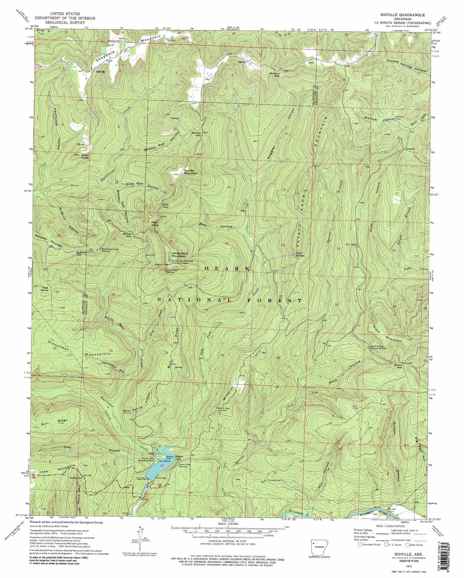
USGS Topo Quad 35093f8 - 1:24,000 scale
| Topo Map Name: | Bidville |
| USGS Topo Quad ID: | 35093f8 |
| Print Size: | ca. 21 1/4" wide x 27" high |
| Southeast Coordinates: | 35.625° N latitude / 93.875° W longitude |
| Map Center Coordinates: | 35.6875° N latitude / 93.9375° W longitude |
| U.S. State: | AR |
| Filename: | o35093f8.jpg |
| Download Map JPG Image: | Bidville topo map 1:24,000 scale |
| Map Type: | Topographic |
| Topo Series: | 7.5´ |
| Map Scale: | 1:24,000 |
| Source of Map Images: | United States Geological Survey (USGS) |
| Alternate Map Versions: |
Bidville AR 1973, updated 1976 Download PDF Buy paper map Bidville AR 1973, updated 1986 Download PDF Buy paper map Bidville AR 2011 Download PDF Buy paper map Bidville AR 2014 Download PDF Buy paper map |
| FStopo: | US Forest Service topo Bidville is available: Download FStopo PDF Download FStopo TIF |
1:24,000 Topo Quads surrounding Bidville
West Fork |
Sulphur City |
Durham |
Japton |
Witter |
Winslow |
Brentwood |
Delaney |
Saint Paul |
Pettigrew |
Mountainburg |
Fern |
Bidville |
Cass |
Yale |
Mountainburg Sw |
Mountainburg Se |
Cravens |
Watalula |
Hunt |
Alma |
Mulberry |
Cecil |
Ozark |
Coal Hill |
> Back to 35093e1 at 1:100,000 scale
> Back to 35092a1 at 1:250,000 scale
> Back to U.S. Topo Maps home
Bidville topo map: Gazetteer
Bidville: Crossings
Milton Ford elevation 182m 597′Bidville: Dams
Shores Lake Dam elevation 207m 679′Bidville: Gaps
Bowles Gap elevation 584m 1916′Bunce Gap elevation 501m 1643′
McMinn Gap elevation 574m 1883′
Mullens Gap elevation 659m 2162′
Stob Gap elevation 609m 1998′
Woods Gap elevation 561m 1840′
Bidville: Oilfields
Paradise Gas Field elevation 478m 1568′Bidville: Parks
Grays Spring Recreation Area elevation 461m 1512′White Rock Mountain Recreation Area elevation 697m 2286′
Bidville: Populated Places
Bidville elevation 681m 2234′Bidville: Reservoirs
Shores Lake elevation 207m 679′Bidville: Ridges
Bliss Ridge elevation 443m 1453′Burr Ridge elevation 456m 1496′
Bidville: Springs
Fugit Springs elevation 556m 1824′Sand Spring elevation 468m 1535′
Bidville: Streams
Dry Fork elevation 243m 797′Long Branch elevation 195m 639′
Phipps Branch elevation 339m 1112′
Salt Fork Creek elevation 189m 620′
White Rock Creek elevation 207m 679′
Bidville: Summits
Alexander Mountain elevation 477m 1564′Black Mountain elevation 629m 2063′
Bowles Mountain elevation 707m 2319′
Mineral Hill elevation 511m 1676′
Pilot Knob elevation 711m 2332′
Potato Knob Mountain elevation 687m 2253′
Sloan Knob elevation 541m 1774′
White Rock Mountain elevation 701m 2299′
Bidville: Trails
Shores Lake Water Rock Spur elevation 241m 790′Bidville: Valleys
Alexander Hollow elevation 231m 757′Bear Hollow elevation 291m 954′
Bliss Spring Hollow elevation 222m 728′
Bowles Gap Hollow elevation 414m 1358′
Deep Hollow elevation 262m 859′
Heathcock Hollow elevation 352m 1154′
Marlum Hollow elevation 555m 1820′
McMinn Hollow elevation 365m 1197′
Nix Hollow elevation 194m 636′
Pine Hollow elevation 280m 918′
Rosson Hollow elevation 180m 590′
Soda Hollow elevation 338m 1108′
Stob Gap Hollow elevation 412m 1351′
Waggley Hollow elevation 313m 1026′
Woods Gap Hollow elevation 400m 1312′
Bidville digital topo map on disk
Buy this Bidville topo map showing relief, roads, GPS coordinates and other geographical features, as a high-resolution digital map file on DVD: