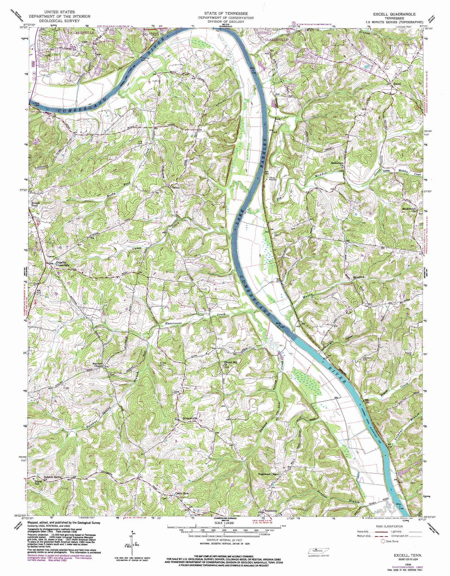
Excell Topo Map Tennessee
To zoom in, hover over the map of Excell
USGS Topo Quad 36087d3 - 1:24,000 scale
| Topo Map Name: | Excell |
| USGS Topo Quad ID: | 36087d3 |
| Print Size: | ca. 21 1/4" wide x 27" high |
| Southeast Coordinates: | 36.375° N latitude / 87.25° W longitude |
| Map Center Coordinates: | 36.4375° N latitude / 87.3125° W longitude |
| U.S. State: | TN |
| Filename: | o36087d3.jpg |
| Download Map JPG Image: | Excell topo map 1:24,000 scale |
| Map Type: | Topographic |
| Topo Series: | 7.5´ |
| Map Scale: | 1:24,000 |
| Source of Map Images: | United States Geological Survey (USGS) |
| Alternate Map Versions: |
Excell TN 1958, updated 1960 Download PDF Buy paper map Excell TN 1958, updated 1968 Download PDF Buy paper map Excell TN 1958, updated 1984 Download PDF Buy paper map Excell TN 2010 Download PDF Buy paper map Excell TN 2013 Download PDF Buy paper map Excell TN 2016 Download PDF Buy paper map |
1:24,000 Topo Quads surrounding Excell
Herndon |
Oak Grove |
Trenton |
Guthrie |
Allensville |
Woodlawn |
New Providence |
Clarksville |
Sango |
Adams |
Needmore |
Palmyra |
Excell |
Henrietta |
Pleasant View |
Ellis Mills |
Slayden |
Cumberland Furnace |
Cheatham Dam |
Ashland City |
Ruskin |
Vanleer |
Charlotte |
Harpeth Valley |
Lillamay |
> Back to 36087a1 at 1:100,000 scale
> Back to 36086a1 at 1:250,000 scale
> Back to U.S. Topo Maps home
Excell topo map: Gazetteer
Excell: Bars
Cotton Bar elevation 109m 357′Coxs Bar elevation 109m 357′
Rock Bars elevation 109m 357′
Whiskey Bar elevation 109m 357′
Excell: Crossings
Edmondsons Ferry (historical) elevation 109m 357′Seven Mile Ferry (historical) elevation 109m 357′
Excell: Dams
Lock B elevation 116m 380′Old Lock and Dam B (historical) elevation 109m 357′
Excell: Islands
Seven Mile Island elevation 110m 360′Excell: Populated Places
Cumberland Hills elevation 148m 485′Deerfield elevation 171m 561′
Excell elevation 179m 587′
Forest Acres elevation 142m 465′
Glenstone elevation 159m 521′
Grantville (historical) elevation 168m 551′
Greenland Farms elevation 123m 403′
Kingsbury elevation 135m 442′
Lakeside Estates elevation 140m 459′
Liverworth elevation 190m 623′
Medallion Acres elevation 150m 492′
Orgains Crossroads elevation 195m 639′
Rotary Hills elevation 172m 564′
Salem elevation 173m 567′
Southern View elevation 129m 423′
Woodridge Estates elevation 181m 593′
Excell: Post Offices
Southside Post Office elevation 175m 574′Excell: Rapids
Davis Ripple elevation 109m 357′Excell: Streams
Big McAdoo Creek elevation 112m 367′Brush Creek elevation 114m 374′
Camp Creek elevation 109m 357′
Dawson Creek elevation 111m 364′
Frazier Branch elevation 110m 360′
Hurricane Creek elevation 109m 357′
Little McAdoo Creek elevation 120m 393′
Muddy Branch elevation 110m 360′
Rocky Ford Creek elevation 110m 360′
Sulphur Branch elevation 110m 360′
Sulphur Spring Branch elevation 121m 396′
Wall Branch elevation 110m 360′
Excell: Valleys
Midnight Hollow elevation 114m 374′Tin Cup Hollow elevation 116m 380′
Excell digital topo map on disk
Buy this Excell topo map showing relief, roads, GPS coordinates and other geographical features, as a high-resolution digital map file on DVD: