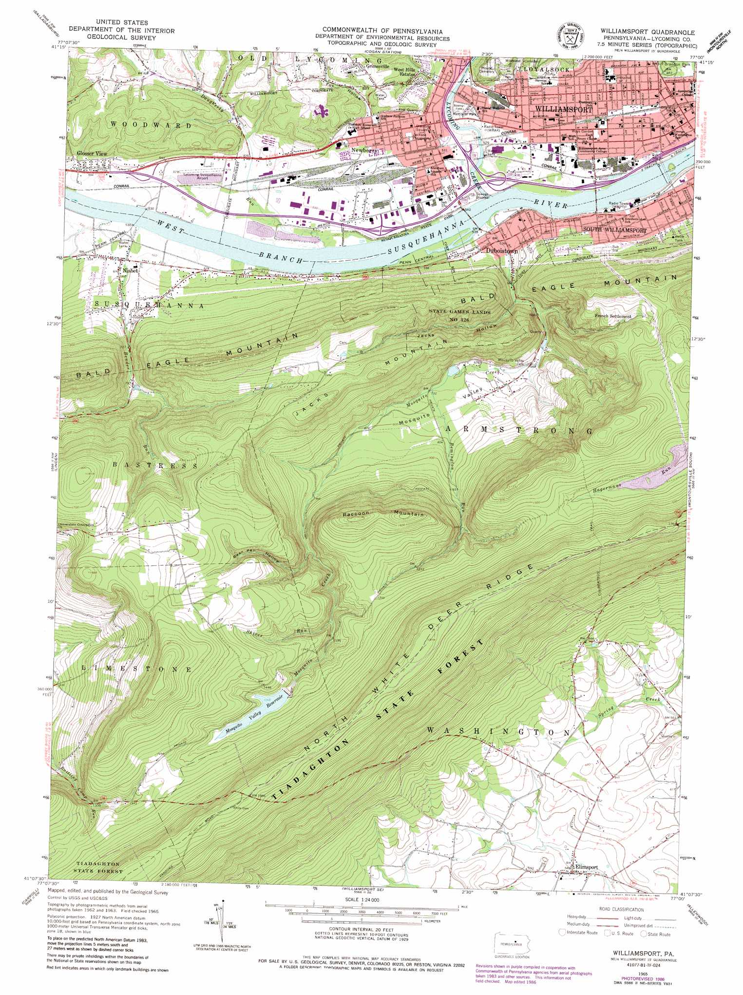
Williamsport Topo Map Pennsylvania
To zoom in, hover over the map of Williamsport
USGS Topo Quad 41077b1 - 1:24,000 scale
| Topo Map Name: | Williamsport |
| USGS Topo Quad ID: | 41077b1 |
| Print Size: | ca. 21 1/4" wide x 27" high |
| Southeast Coordinates: | 41.125° N latitude / 77° W longitude |
| Map Center Coordinates: | 41.1875° N latitude / 77.0625° W longitude |
| U.S. State: | PA |
| Filename: | o41077b1.jpg |
| Download Map JPG Image: | Williamsport topo map 1:24,000 scale |
| Map Type: | Topographic |
| Topo Series: | 7.5´ |
| Map Scale: | 1:24,000 |
| Source of Map Images: | United States Geological Survey (USGS) |
| Alternate Map Versions: |
Williamsport PA 1965, updated 1967 Download PDF Buy paper map Williamsport PA 1965, updated 1973 Download PDF Buy paper map Williamsport PA 1965, updated 1986 Download PDF Buy paper map Williamsport PA 1965, updated 1986 Download PDF Buy paper map Williamsport PA 1994, updated 1999 Download PDF Buy paper map Williamsport PA 2010 Download PDF Buy paper map Williamsport PA 2013 Download PDF Buy paper map Williamsport PA 2016 Download PDF Buy paper map |
1:24,000 Topo Quads surrounding Williamsport
English Center |
White Pine |
Trout Run |
Bodines |
Barbours |
Waterville |
Salladasburg |
Cogan Station |
Montoursville North |
Huntersville |
Jersey Shore |
Linden |
Williamsport |
Montoursville South |
Muncy |
Loganton |
Carroll |
Williamsport Se |
Allenwood |
Milton |
Woodward |
Hartleton |
Mifflinburg |
Lewisburg |
Northumberland |
> Back to 41077a1 at 1:100,000 scale
> Back to 41076a1 at 1:250,000 scale
> Back to U.S. Topo Maps home
Williamsport topo map: Gazetteer
Williamsport: Airports
Williamsport Hospital Heliport elevation 165m 541′Williamsport: Dams
Mosquito Run Dam elevation 213m 698′Williamsport: Forests
Tiadaghton State Forest elevation 455m 1492′Williamsport: Parks
Bowman Field elevation 158m 518′Brandon Park elevation 170m 557′
David Person Field elevation 170m 557′
Jackson Playground elevation 161m 528′
Robert L Shangraw Athletic Complex elevation 170m 557′
State Game Lands Number 126 elevation 311m 1020′
Susquehanna State Park elevation 158m 518′
Ways Garden Park elevation 160m 524′
Williamsport: Populated Places
Duboistown elevation 162m 531′Elimsport elevation 170m 557′
French Settlement elevation 372m 1220′
Glosser View elevation 181m 593′
Grimesville elevation 231m 757′
Newberry elevation 161m 528′
Nisbet elevation 173m 567′
West Hills Estates elevation 193m 633′
Williamsport elevation 158m 518′
Williamsport: Reservoirs
Mosquito Run Reservoir elevation 213m 698′Mosquito Valley Reservoir elevation 411m 1348′
Williamsport: Streams
Bender Run elevation 158m 518′Daugherty Run elevation 154m 505′
Lycoming Creek elevation 158m 518′
Mosquito Creek elevation 154m 505′
Remington Run elevation 220m 721′
Shires Run elevation 359m 1177′
Williamsport: Summits
Jacks Mountain elevation 469m 1538′Raccoon Mountain elevation 525m 1722′
Williamsport: Trails
Culbertson Trail elevation 441m 1446′Williamsport: Valleys
Bear Pen Hollow elevation 359m 1177′Fox Hollow elevation 176m 577′
Jacks Hollow elevation 165m 541′
Mosquito Valley elevation 195m 639′
Williamsport digital topo map on disk
Buy this Williamsport topo map showing relief, roads, GPS coordinates and other geographical features, as a high-resolution digital map file on DVD:
New York, Vermont, Connecticut & Western Massachusetts
Buy digital topo maps: New York, Vermont, Connecticut & Western Massachusetts