Corsica Topo Map Pennsylvania
To zoom in, hover over the map of Corsica
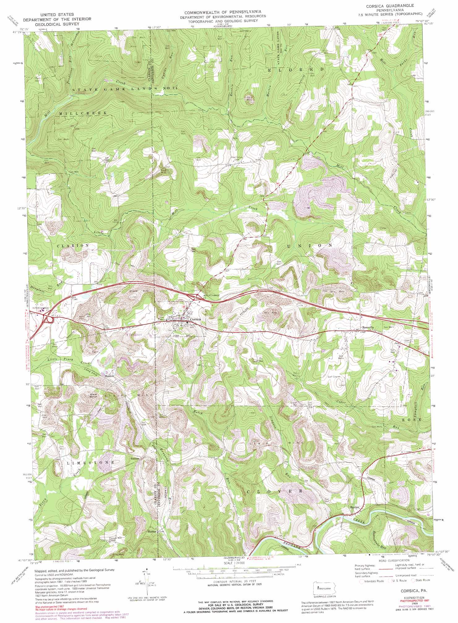
USGS Topo Quad 41079b2 - 1:24,000 scale
| Topo Map Name: | Corsica |
| USGS Topo Quad ID: | 41079b2 |
| Print Size: | ca. 21 1/4" wide x 27" high |
| Southeast Coordinates: | 41.125° N latitude / 79.125° W longitude |
| Map Center Coordinates: | 41.1875° N latitude / 79.1875° W longitude |
| U.S. State: | PA |
| Filename: | o41079b2.jpg |
| Download Map JPG Image: | Corsica topo map 1:24,000 scale |
| Map Type: | Topographic |
| Topo Series: | 7.5´ |
| Map Scale: | 1:24,000 |
| Source of Map Images: | United States Geological Survey (USGS) |
| Alternate Map Versions: |
Corsica PA 1969, updated 1972 Download PDF Buy paper map Corsica PA 1969, updated 1982 Download PDF Buy paper map Corsica PA 1969, updated 1991 Download PDF Buy paper map Corsica PA 1969, updated 1991 Download PDF Buy paper map Corsica PA 2010 Download PDF Buy paper map Corsica PA 2013 Download PDF Buy paper map Corsica PA 2016 Download PDF Buy paper map |
1:24,000 Topo Quads surrounding Corsica
Tionesta |
Tylersburg |
Marienville West |
Marienville East |
Hallton |
Fryburg |
Lucinda |
Cooksburg |
Sigel |
Munderf |
Clarion |
Strattanville |
Corsica |
Brookville |
Hazen |
Sligo |
New Bethlehem |
Summerville |
Coolspring |
Reynoldsville |
Templeton |
Distant |
Dayton |
Valier |
Punxsutawney |
> Back to 41079a1 at 1:100,000 scale
> Back to 41078a1 at 1:250,000 scale
> Back to U.S. Topo Maps home
Corsica topo map: Gazetteer
Corsica: Airports
Shirley Field elevation 478m 1568′Corsica: Populated Places
Baxter elevation 364m 1194′Corsica elevation 488m 1601′
Harlan elevation 386m 1266′
Holden elevation 486m 1594′
Roseville elevation 502m 1646′
Sutton elevation 463m 1519′
Corsica: Post Offices
Corsica Post Office (historical) elevation 488m 1601′Corsica: Streams
Campbell Run elevation 394m 1292′Crooks Run elevation 401m 1315′
Hugh Run elevation 423m 1387′
Kyle Run elevation 426m 1397′
Long Run elevation 429m 1407′
Martin Run elevation 417m 1368′
McCanna Run elevation 428m 1404′
Parks Run elevation 450m 1476′
Pendleton Run elevation 389m 1276′
Rankin Run elevation 413m 1354′
Rattlesnake Run elevation 357m 1171′
Simpson Run elevation 357m 1171′
Spangler Run elevation 428m 1404′
Thompson Run elevation 356m 1167′
Updike Run elevation 405m 1328′
Corsica digital topo map on disk
Buy this Corsica topo map showing relief, roads, GPS coordinates and other geographical features, as a high-resolution digital map file on DVD:
 map DVD")