Pegram Topo Map Idaho
To zoom in, hover over the map of Pegram
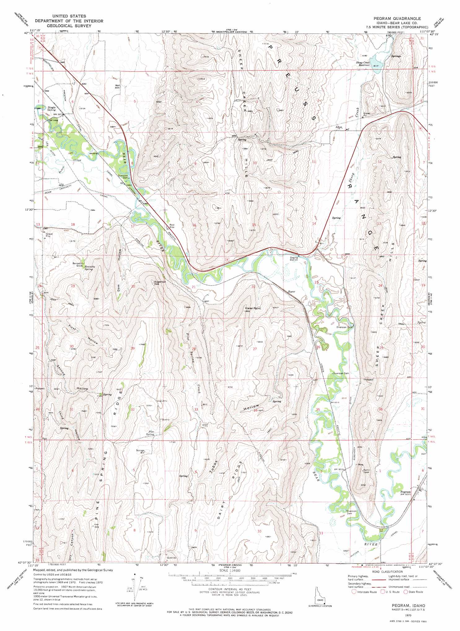
USGS Topo Quad 42111b2 - 1:24,000 scale
| Topo Map Name: | Pegram |
| USGS Topo Quad ID: | 42111b2 |
| Print Size: | ca. 21 1/4" wide x 27" high |
| Southeast Coordinates: | 42.125° N latitude / 111.125° W longitude |
| Map Center Coordinates: | 42.1875° N latitude / 111.1875° W longitude |
| U.S. State: | ID |
| Filename: | o42111b2.jpg |
| Download Map JPG Image: | Pegram topo map 1:24,000 scale |
| Map Type: | Topographic |
| Topo Series: | 7.5´ |
| Map Scale: | 1:24,000 |
| Source of Map Images: | United States Geological Survey (USGS) |
| Alternate Map Versions: |
Pegram ID 1970, updated 1973 Download PDF Buy paper map Pegram ID 2010 Download PDF Buy paper map Pegram ID 2013 Download PDF Buy paper map |
1:24,000 Topo Quads surrounding Pegram
Nounan |
Georgetown |
Meade Peak |
Giraffe Creek |
Salt Flat |
Ovid |
Montpelier |
Montpelier Canyon |
Geneva |
Huff Lake |
Paris |
Dingle |
Pegram |
Border |
Marse |
Saint Charles |
Bear Lake North |
Pegram Creek |
Boundary Ridge |
Cokeville |
Garden City |
Bear Lake South |
Sheeppen Creek |
South Lake |
Beckwith |
> Back to 42111a1 at 1:100,000 scale
> Back to 42110a1 at 1:250,000 scale
> Back to U.S. Topo Maps home
Pegram topo map: Gazetteer
Pegram: Areas
Bennetts Grove elevation 1889m 6197′Pegram: Canals
Nuffer Canal elevation 1840m 6036′Peg Leg Ditch elevation 1819m 5967′
Pegram: Capes
Harer Point elevation 2030m 6660′Pegram: Dams
Sheep Creek Dam elevation 1867m 6125′Pegram: Populated Places
Alton elevation 1850m 6069′Harer elevation 1830m 6003′
Pegram elevation 1839m 6033′
Pegram: Reservoirs
Sheep Creek Reservoir elevation 1867m 6125′Pegram: Ridges
Dairy Ridge elevation 2139m 7017′Pine Spring Ridge elevation 2394m 7854′
Pegram: Springs
Bennetts Spring elevation 1903m 6243′Pine Spring elevation 2160m 7086′
Pegram: Streams
Pegram Creek elevation 1839m 6033′Pine Spring Creek elevation 1832m 6010′
Sheep Creek elevation 1827m 5994′
West Fork Sheep Creek elevation 1874m 6148′
Pegram: Valleys
Dam Hollow elevation 1829m 6000′First Hollow elevation 1919m 6295′
Second Hollow elevation 1959m 6427′
Third Hollow elevation 1958m 6423′
Tubbs Hollow elevation 1838m 6030′
Pegram digital topo map on disk
Buy this Pegram topo map showing relief, roads, GPS coordinates and other geographical features, as a high-resolution digital map file on DVD: