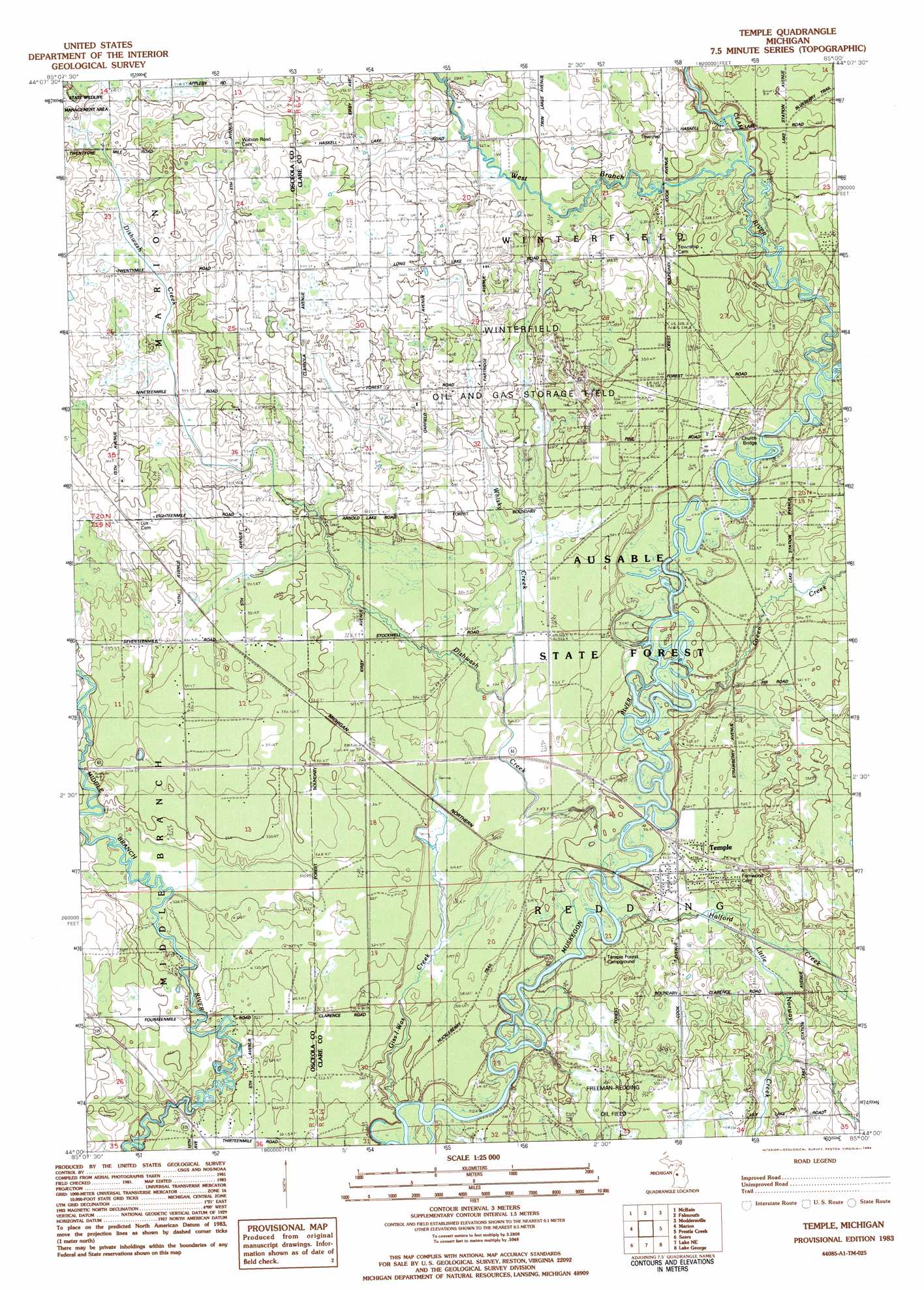
Temple Topo Map Michigan
To zoom in, hover over the map of Temple
USGS Topo Quad 44085a1 - 1:25,000 scale
| Topo Map Name: | Temple |
| USGS Topo Quad ID: | 44085a1 |
| Print Size: | ca. 21 1/4" wide x 27" high |
| Southeast Coordinates: | 44° N latitude / 85° W longitude |
| Map Center Coordinates: | 44.0625° N latitude / 85.0625° W longitude |
| U.S. State: | MI |
| Filename: | l44085a1.jpg |
| Download Map JPG Image: | Temple topo map 1:25,000 scale |
| Map Type: | Topographic |
| Topo Series: | 7.5´ |
| Map Scale: | 1:25,000 |
| Source of Map Images: | United States Geological Survey (USGS) |
| Alternate Map Versions: |
Temple MI 1983, updated 1984 Download PDF Buy paper map |
1:24,000 Topo Quads surrounding Temple
Jennings |
Lake City |
Dinca |
Merritt |
Houghton Lake |
Lucas |
Mcbain |
Falmouth |
Moddersville |
Cooperton |
Dighton |
Marion |
Temple |
Prestle Creek |
Harrison |
Evart |
Sears |
Lake Ne |
Lake George |
Hatton |
Chippewa Lake North |
Merrill Lake |
Lake |
Woods |
Clare |
> Back to 44085a1 at 1:100,000 scale
> Back to 44084a1 at 1:250,000 scale
> Back to U.S. Topo Maps home
Temple topo map: Gazetteer
Temple: Bridges
Church Bridge elevation 318m 1043′Temple: Oilfields
Freeman-Redding Oil Field elevation 327m 1072′Winterfield Oil and Gas Storage Field elevation 334m 1095′
Temple: Populated Places
Temple elevation 321m 1053′Temple: Post Offices
Grandon Post Office (historical) elevation 328m 1076′Pennock Post Office (historical) elevation 327m 1072′
Temple Post Office (historical) elevation 321m 1053′
Winterfield Post Office (historical) elevation 328m 1076′
Temple: Streams
Clam River elevation 318m 1043′Dishwash Creek elevation 321m 1053′
Giss-I-Was Creek elevation 312m 1023′
Green Creek elevation 315m 1033′
Halford Creek elevation 314m 1030′
Little Norway Creek elevation 315m 1033′
West Branch Clam River elevation 322m 1056′
West Branch Middle Branch River elevation 324m 1062′
Whisky Creek elevation 313m 1026′
Temple digital topo map on disk
Buy this Temple topo map showing relief, roads, GPS coordinates and other geographical features, as a high-resolution digital map file on DVD: