Bear Mountain Topo Map Idaho
To zoom in, hover over the map of Bear Mountain
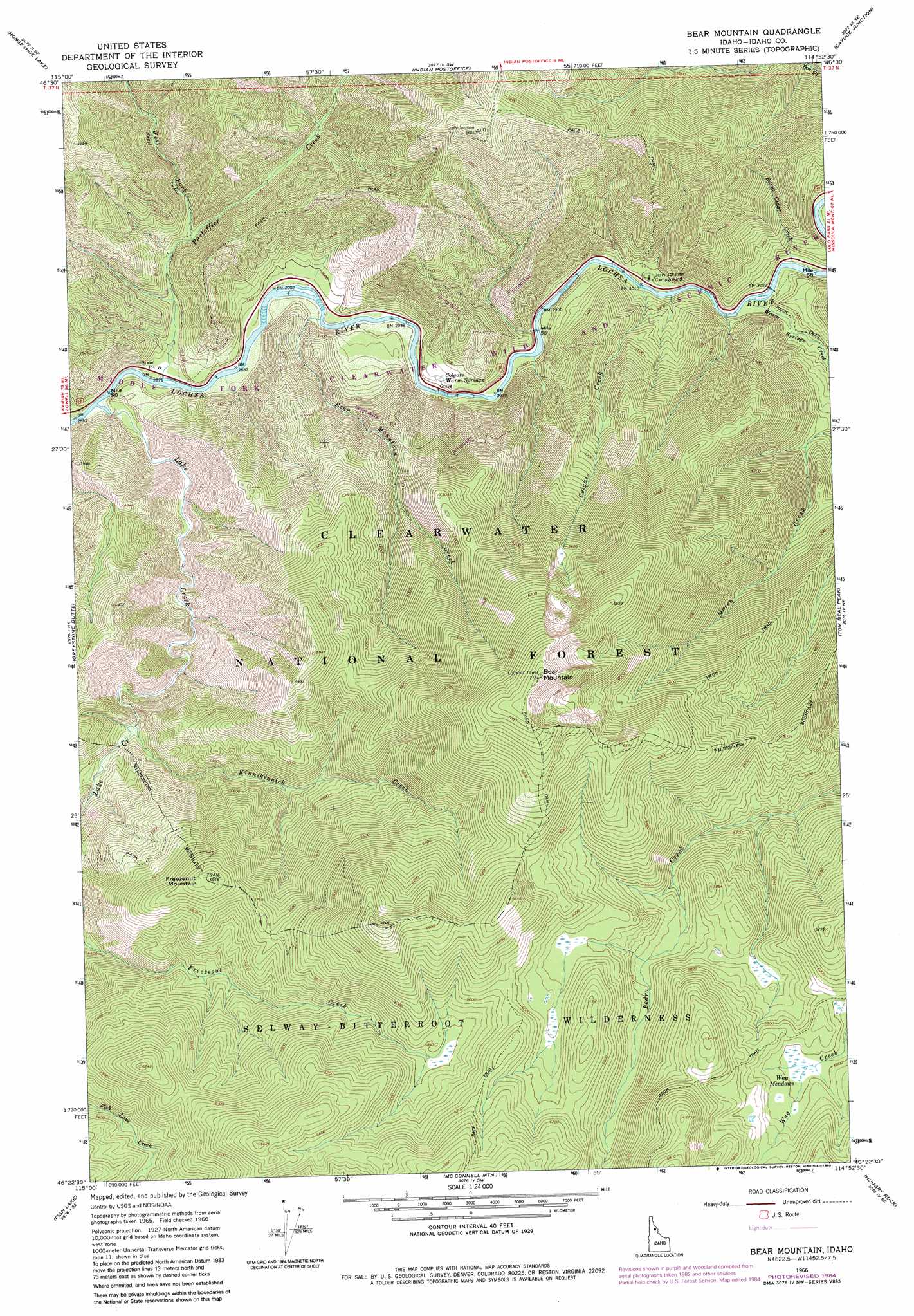
USGS Topo Quad 46114d8 - 1:24,000 scale
| Topo Map Name: | Bear Mountain |
| USGS Topo Quad ID: | 46114d8 |
| Print Size: | ca. 21 1/4" wide x 27" high |
| Southeast Coordinates: | 46.375° N latitude / 114.875° W longitude |
| Map Center Coordinates: | 46.4375° N latitude / 114.9375° W longitude |
| U.S. State: | ID |
| Filename: | o46114d8.jpg |
| Download Map JPG Image: | Bear Mountain topo map 1:24,000 scale |
| Map Type: | Topographic |
| Topo Series: | 7.5´ |
| Map Scale: | 1:24,000 |
| Source of Map Images: | United States Geological Survey (USGS) |
| Alternate Map Versions: |
Bear Mountain ID 1966, updated 1969 Download PDF Buy paper map Bear Mountain ID 1966, updated 1984 Download PDF Buy paper map Bear Mountain ID 1994, updated 1997 Download PDF Buy paper map Bear Mountain ID 2011 Download PDF Buy paper map Bear Mountain ID 2013 Download PDF Buy paper map |
| FStopo: | US Forest Service topo Bear Mountain is available: Download FStopo PDF Download FStopo TIF |
1:24,000 Topo Quads surrounding Bear Mountain
Scurvy Mountain |
Gorman Hill |
Toboggan Ridge |
Rhodes Peak |
Granite Pass |
Lookout Peak |
Horseshoe Lake |
Indian Postoffice |
Cayuse Junction |
Rocky Point |
Holly Creek |
Greystone Butte |
Bear Mountain |
Tom Beal Peak |
Grave Peak |
Greenside Butte |
Fish Lake |
Mcconnell Mountain |
Hungry Rock |
Cedar Ridge |
Fenn Mountain |
Big Rock Mountain |
Shissler Peak |
Freeman Peak |
Wahoo Peak |
> Back to 46114a1 at 1:100,000 scale
> Back to 46114a1 at 1:250,000 scale
> Back to U.S. Topo Maps home
Bear Mountain topo map: Gazetteer
Bear Mountain: Flats
Wag Meadows elevation 1766m 5793′Bear Mountain: Springs
Colgate Warm Springs elevation 938m 3077′Bear Mountain: Streams
Bear Mountain Creek elevation 892m 2926′Burnt Cedar Creek elevation 1012m 3320′
Colgate Creek elevation 970m 3182′
Gypsy Creek elevation 1640m 5380′
Kinnikinnick Creek elevation 1162m 3812′
Lake Creek elevation 875m 2870′
Postoffice Creek elevation 879m 2883′
Warm Springs Creek elevation 933m 3061′
West Fork Postoffice Creek elevation 940m 3083′
Bear Mountain: Summits
Bear Mountain elevation 2172m 7125′Freezeout Mountain elevation 1814m 5951′
Bear Mountain: Trails
Colgate Licks Nature National Recreation Trail elevation 939m 3080′Bear Mountain digital topo map on disk
Buy this Bear Mountain topo map showing relief, roads, GPS coordinates and other geographical features, as a high-resolution digital map file on DVD: