Shulerville Topo Map South Carolina
To zoom in, hover over the map of Shulerville
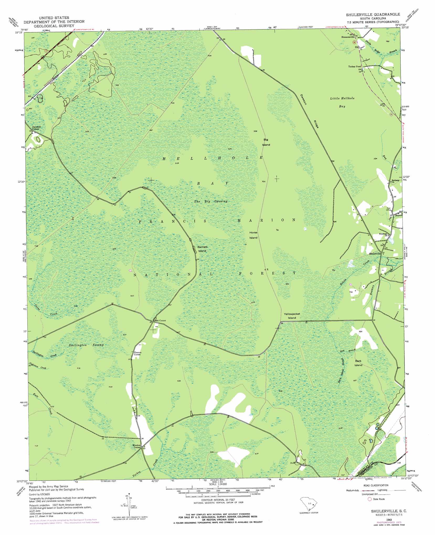
USGS Topo Quad 33079b6 - 1:24,000 scale
| Topo Map Name: | Shulerville |
| USGS Topo Quad ID: | 33079b6 |
| Print Size: | ca. 21 1/4" wide x 27" high |
| Southeast Coordinates: | 33.125° N latitude / 79.625° W longitude |
| Map Center Coordinates: | 33.1875° N latitude / 79.6875° W longitude |
| U.S. State: | SC |
| Filename: | o33079b6.jpg |
| Download Map JPG Image: | Shulerville topo map 1:24,000 scale |
| Map Type: | Topographic |
| Topo Series: | 7.5´ |
| Map Scale: | 1:24,000 |
| Source of Map Images: | United States Geological Survey (USGS) |
| Alternate Map Versions: |
Shulerville SC 1943, updated 1962 Download PDF Buy paper map Shulerville SC 1943, updated 1976 Download PDF Buy paper map Shulerville SC 2011 Download PDF Buy paper map Shulerville SC 2014 Download PDF Buy paper map |
| FStopo: | US Forest Service topo Shulerville is available: Download FStopo PDF Download FStopo TIF |
1:24,000 Topo Quads surrounding Shulerville
Saint Stephens |
Blakely |
Trio |
Andrews |
Olin |
Bonneau |
Wedboo Creek |
Jamestown |
Cedar Creek |
Kilsock Bay |
Cordesville |
Bethera |
Shulerville |
Honey Hill |
Santee |
Kittredge |
Huger |
Ocean Bay |
Awendaw |
Mcclellanville |
North Charleston |
Cainhoy |
Sewee Bay |
Bull Island |
> Back to 33079a1 at 1:100,000 scale
> Back to 33078a1 at 1:250,000 scale
> Back to U.S. Topo Maps home
Shulerville topo map: Gazetteer
Shulerville: Bays
Little Hellhole Bay elevation 9m 29′Shulerville: Forests
Francis Marion National Forest elevation 9m 29′Shulerville: Islands
Bark Island elevation 9m 29′Barnett Island elevation 12m 39′
Big Island elevation 9m 29′
Dawson Ridge elevation 9m 29′
Horse Island elevation 9m 29′
Peterstand Island elevation 9m 29′
Yellowjacket Island elevation 9m 29′
Shulerville: Populated Places
Farewell Corner elevation 15m 49′Oak Corner elevation 12m 39′
Shulerville elevation 8m 26′
Simmonsville elevation 9m 29′
Thomas Corner elevation 9m 29′
Turkey Pond elevation 9m 29′
Windom Corner elevation 9m 29′
Shulerville: Post Offices
Shulerville Post Office elevation 9m 29′Shulerville: Streams
Bark Island Slough elevation 9m 29′Beaman Branch elevation 5m 16′
Gum Branch elevation 9m 29′
Shulerville: Swamps
Darlington Swamp elevation 9m 29′Hellhole Bay elevation 9m 29′
The Big Opening elevation 9m 29′
Shulerville digital topo map on disk
Buy this Shulerville topo map showing relief, roads, GPS coordinates and other geographical features, as a high-resolution digital map file on DVD:
South Carolina, Western North Carolina & Northeastern Georgia
Buy digital topo maps: South Carolina, Western North Carolina & Northeastern Georgia