Uniontown Topo Map Arkansas
To zoom in, hover over the map of Uniontown
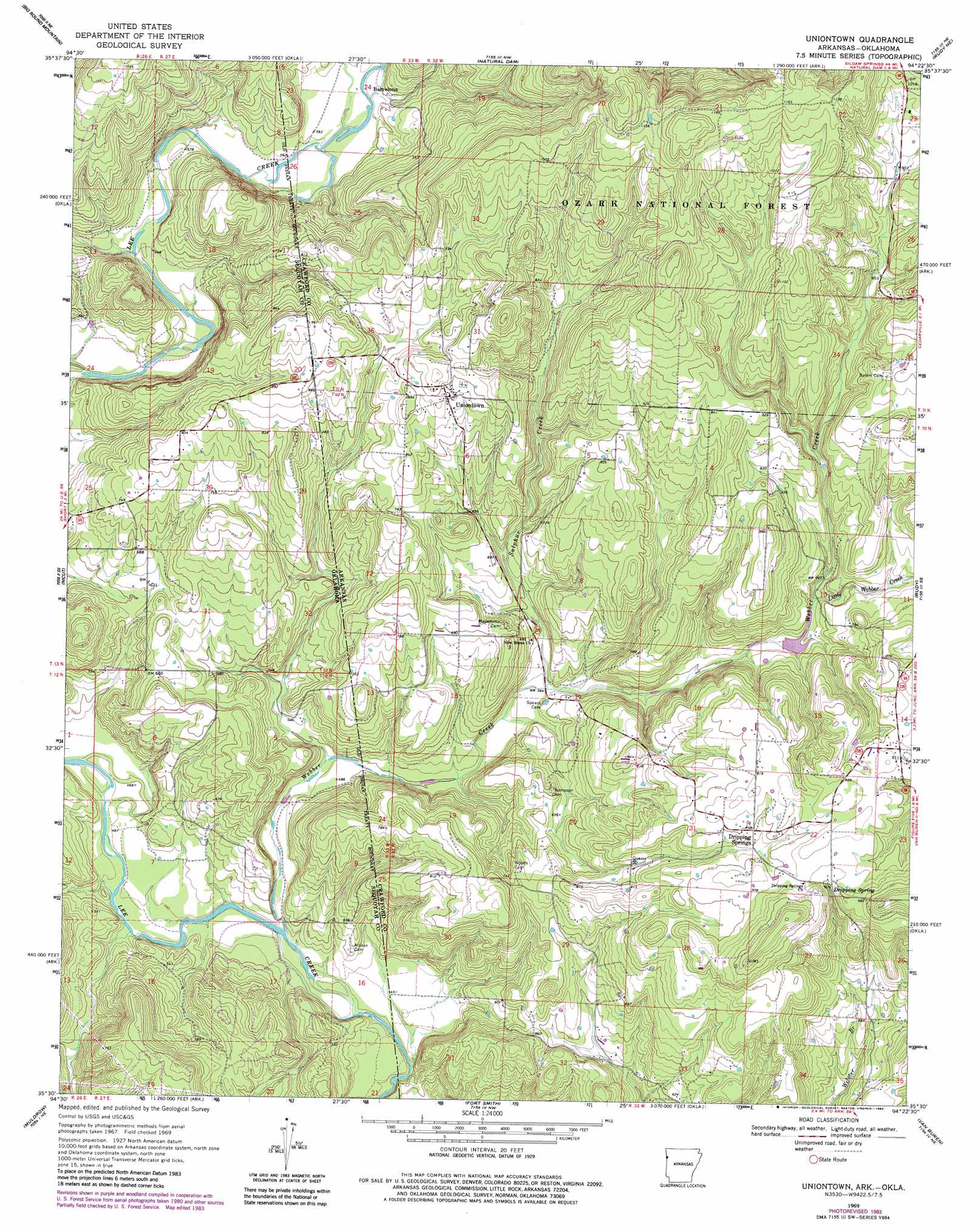
USGS Topo Quad 35094e4 - 1:24,000 scale
| Topo Map Name: | Uniontown |
| USGS Topo Quad ID: | 35094e4 |
| Print Size: | ca. 21 1/4" wide x 27" high |
| Southeast Coordinates: | 35.5° N latitude / 94.375° W longitude |
| Map Center Coordinates: | 35.5625° N latitude / 94.4375° W longitude |
| U.S. States: | AR, OK |
| Filename: | o35094e4.jpg |
| Download Map JPG Image: | Uniontown topo map 1:24,000 scale |
| Map Type: | Topographic |
| Topo Series: | 7.5´ |
| Map Scale: | 1:24,000 |
| Source of Map Images: | United States Geological Survey (USGS) |
| Alternate Map Versions: |
Uniontown AR 1969, updated 1971 Download PDF Buy paper map Uniontown AR 1969, updated 1982 Download PDF Buy paper map Uniontown AR 1969, updated 1983 Download PDF Buy paper map Uniontown AR 2011 Download PDF Buy paper map Uniontown AR 2014 Download PDF Buy paper map |
| FStopo: | US Forest Service topo Uniontown is available: Download FStopo PDF Download FStopo TIF |
1:24,000 Topo Quads surrounding Uniontown
Stilwell West |
Stilwell East |
Evansville |
Strickler |
Winslow |
Greasy |
Big Round Mountain |
Natural Dam |
Rudy Ne |
Mountainburg |
Brushy |
Nicut |
Uniontown |
Rudy |
Mountainburg Sw |
Gans |
Muldrow |
Fort Smith |
Van Buren |
Alma |
Muldrow Sw |
Fort Coffee |
South Fort Smith |
Barling |
Lavaca |
> Back to 35094e1 at 1:100,000 scale
> Back to 35094a1 at 1:250,000 scale
> Back to U.S. Topo Maps home
Uniontown topo map: Gazetteer
Uniontown: Airports
Strang Airpark elevation 208m 682′Uniontown: Populated Places
Barcelona elevation 167m 547′Dripping Springs elevation 270m 885′
Short elevation 229m 751′
Uniontown elevation 264m 866′
Uniontown: Post Offices
Uniontown Post Office elevation 265m 869′Uniontown: Springs
Dripping Spring elevation 268m 879′Uniontown: Streams
Little Webber Creek elevation 201m 659′Sulphur Creek elevation 164m 538′
Webber Creek elevation 133m 436′
Webber Creek elevation 130m 426′
Uniontown digital topo map on disk
Buy this Uniontown topo map showing relief, roads, GPS coordinates and other geographical features, as a high-resolution digital map file on DVD: