Interior Topo Map Virginia
To zoom in, hover over the map of Interior
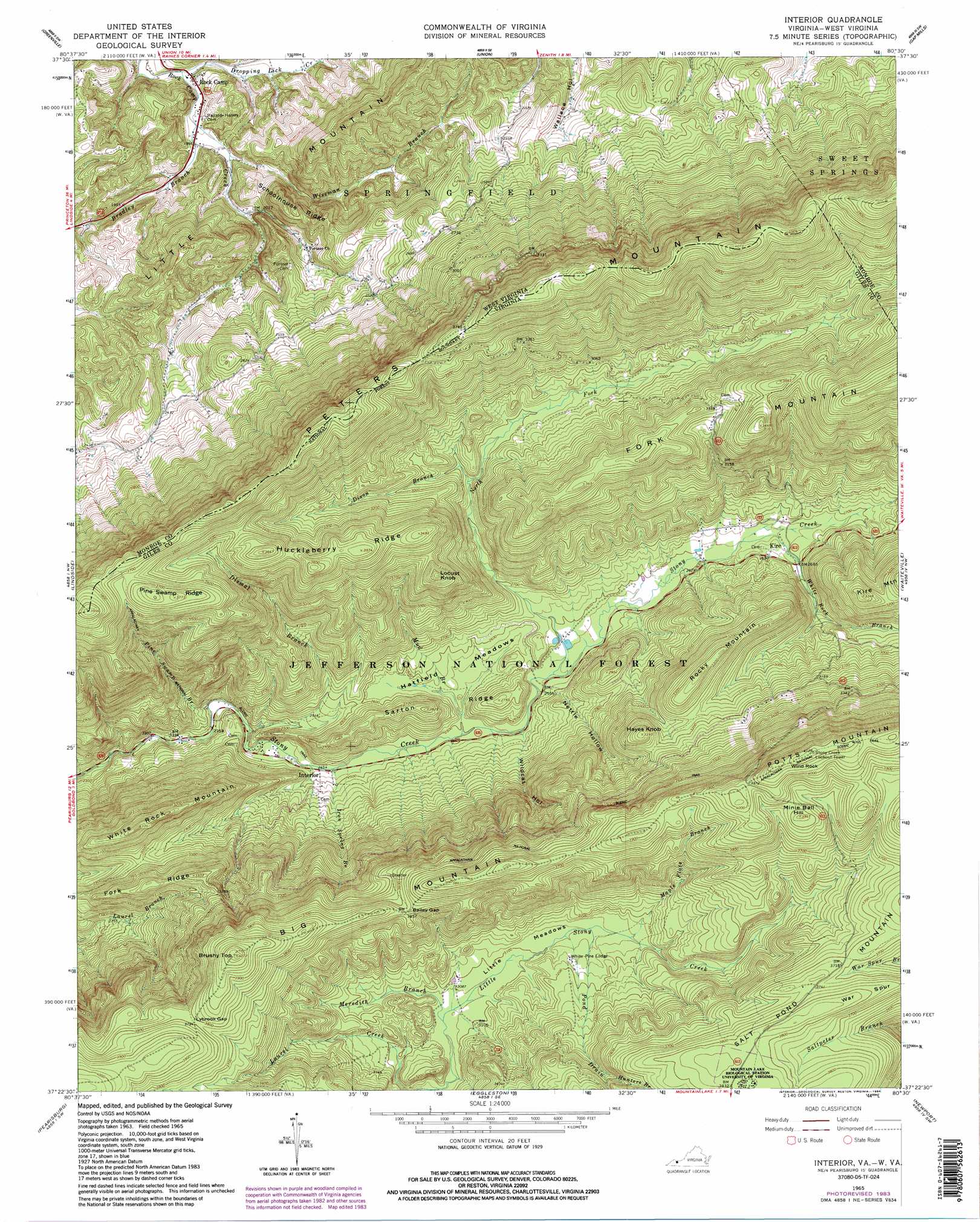
USGS Topo Quad 37080d5 - 1:24,000 scale
| Topo Map Name: | Interior |
| USGS Topo Quad ID: | 37080d5 |
| Print Size: | ca. 21 1/4" wide x 27" high |
| Southeast Coordinates: | 37.375° N latitude / 80.5° W longitude |
| Map Center Coordinates: | 37.4375° N latitude / 80.5625° W longitude |
| U.S. States: | VA, WV |
| Filename: | o37080d5.jpg |
| Download Map JPG Image: | Interior topo map 1:24,000 scale |
| Map Type: | Topographic |
| Topo Series: | 7.5´ |
| Map Scale: | 1:24,000 |
| Source of Map Images: | United States Geological Survey (USGS) |
| Alternate Map Versions: |
Interior VA 1965, updated 1966 Download PDF Buy paper map Interior VA 1965, updated 1975 Download PDF Buy paper map Interior VA 1965, updated 1983 Download PDF Buy paper map Interior VA 1965, updated 1984 Download PDF Buy paper map Interior VA 1965, updated 1984 Download PDF Buy paper map Interior VA 2011 Download PDF Buy paper map Interior VA 2013 Download PDF Buy paper map Interior VA 2016 Download PDF Buy paper map |
| FStopo: | US Forest Service topo Interior is available: Download FStopo PDF Download FStopo TIF |
1:24,000 Topo Quads surrounding Interior
Talcott |
Alderson |
Fort Spring |
Ronceverte |
Glace |
Forest Hill |
Greenville |
Union |
Gap Mills |
Paint Bank |
Peterstown |
Lindside |
Interior |
Waiteville |
Craig Springs |
Narrows |
Pearisburg |
Eggleston |
Newport |
Mcdonalds Mill |
White Gate |
Staffordsville |
Radford North |
Blacksburg |
Ironto |
> Back to 37080a1 at 1:100,000 scale
> Back to 37080a1 at 1:250,000 scale
> Back to U.S. Topo Maps home
Interior topo map: Gazetteer
Interior: Basins
Little Meadows elevation 944m 3097′Interior: Flats
Hatfield Meadows elevation 782m 2565′Interior: Gaps
Bailey Gap elevation 1106m 3628′Lybrook Gap elevation 1157m 3795′
Interior: Pillars
Stony Creek Lookout Tower elevation 1258m 4127′Interior: Populated Places
Kire elevation 817m 2680′Rock Camp elevation 554m 1817′
White Pine Lodge elevation 969m 3179′
Interior: Ridges
Big Mountain elevation 1127m 3697′Huckleberry Ridge elevation 1086m 3562′
Little Mountain elevation 794m 2604′
Pine Swamp Ridge elevation 1148m 3766′
Sarton Ridge elevation 857m 2811′
Schoolhouse Ridge elevation 704m 2309′
Interior: Springs
Rock Camp Spring elevation 660m 2165′Interior: Streams
Bradley Branch elevation 561m 1840′Dismal Branch elevation 733m 2404′
Dixon Branch elevation 870m 2854′
Dropping Lick Creek elevation 550m 1804′
Hemlock Branch elevation 932m 3057′
Hunters Branch elevation 1049m 3441′
Iron Spring Branch elevation 748m 2454′
Maple Flats Branch elevation 962m 3156′
Meredith Branch elevation 934m 3064′
Mud Branch elevation 761m 2496′
North Fork Stony Creek elevation 780m 2559′
Pine Swamp Branch elevation 720m 2362′
Pond Drain elevation 953m 3126′
White Rock Branch elevation 804m 2637′
White Rock Branch elevation 804m 2637′
Wiseman Branch elevation 573m 1879′
Interior: Summits
Brushy Top elevation 1236m 4055′Hayes Knob elevation 1032m 3385′
Locust Knob elevation 1049m 3441′
Minie Ball Hill elevation 1197m 3927′
Rocky Mountain elevation 1020m 3346′
White Rock Mountain elevation 1013m 3323′
Wind Rock elevation 1246m 4087′
Wrights Peak elevation 1238m 4061′
Interior: Trails
Allegheny Trail elevation 1129m 3704′Alleheny Trail elevation 1129m 3704′
Falt Peter Trail elevation 1046m 3431′
Interior: Valleys
Epling Draft elevation 815m 2673′Epling Draft elevation 815m 2673′
Nettle Hollow elevation 784m 2572′
Wildcat Hollow elevation 774m 2539′
Interior digital topo map on disk
Buy this Interior topo map showing relief, roads, GPS coordinates and other geographical features, as a high-resolution digital map file on DVD:
Western Virginia & Southern West Virginia
Buy digital topo maps: Western Virginia & Southern West Virginia