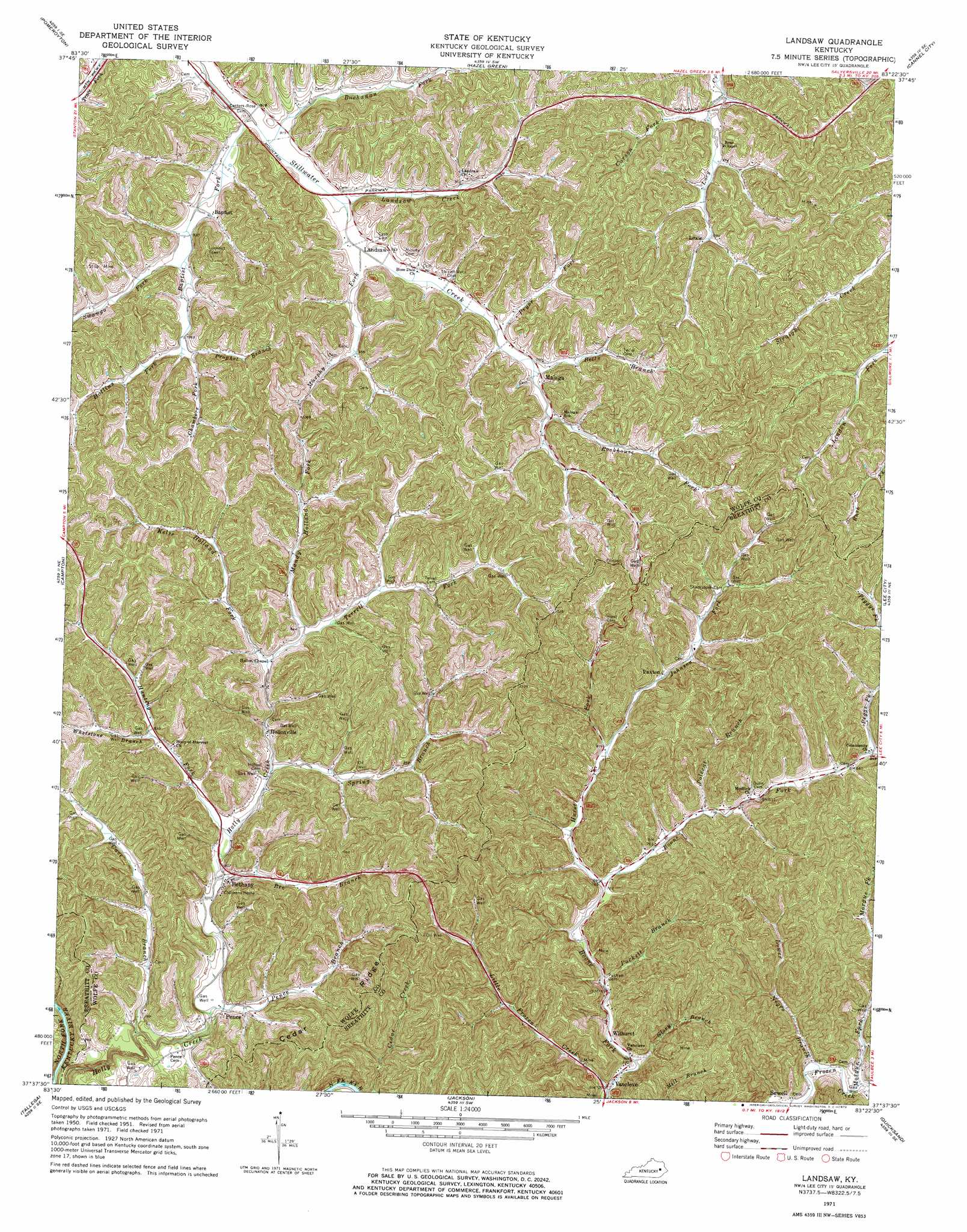
Landsaw Topo Map Kentucky
To zoom in, hover over the map of Landsaw
USGS Topo Quad 37083f4 - 1:24,000 scale
| Topo Map Name: | Landsaw |
| USGS Topo Quad ID: | 37083f4 |
| Print Size: | ca. 21 1/4" wide x 27" high |
| Southeast Coordinates: | 37.625° N latitude / 83.375° W longitude |
| Map Center Coordinates: | 37.6875° N latitude / 83.4375° W longitude |
| U.S. State: | KY |
| Filename: | o37083f4.jpg |
| Download Map JPG Image: | Landsaw topo map 1:24,000 scale |
| Map Type: | Topographic |
| Topo Series: | 7.5´ |
| Map Scale: | 1:24,000 |
| Source of Map Images: | United States Geological Survey (USGS) |
| Alternate Map Versions: |
Landsaw KY 1951, updated 1953 Download PDF Buy paper map Landsaw KY 1961, updated 1963 Download PDF Buy paper map Landsaw KY 1971, updated 1973 Download PDF Buy paper map Landsaw KY 2010 Download PDF Buy paper map Landsaw KY 2013 Download PDF Buy paper map Landsaw KY 2016 Download PDF Buy paper map |
1:24,000 Topo Quads surrounding Landsaw
Frenchburg |
Scranton |
Ezel |
West Liberty |
Lenox |
Slade |
Pomeroyton |
Hazel Green |
Cannel City |
White Oak |
Zachariah |
Campton |
Landsaw |
Lee City |
Seitz |
Beattyville |
Tallega |
Jackson |
Quicksand |
Guage |
Booneville |
Cowcreek |
Canoe |
Haddix |
Noble |
> Back to 37083e1 at 1:100,000 scale
> Back to 37082a1 at 1:250,000 scale
> Back to U.S. Topo Maps home
Landsaw topo map: Gazetteer
Landsaw: Populated Places
Baileyfield elevation 255m 836′Baptist elevation 285m 935′
Bethany elevation 253m 830′
Chamber Fork elevation 299m 980′
Hollonville elevation 248m 813′
Landsaw elevation 291m 954′
Lexie elevation 325m 1066′
Malaga elevation 312m 1023′
Paxton elevation 254m 833′
Pence elevation 245m 803′
Rose Chapel elevation 293m 961′
Rosedale elevation 286m 938′
Sewell elevation 224m 734′
Vancleve elevation 219m 718′
Wilhurst elevation 224m 734′
Landsaw: Post Offices
Baptist Post Office (historical) elevation 284m 931′Bethany Post Office elevation 247m 810′
Lacey Post Office (historical) elevation 299m 980′
Landsaw Post Office (historical) elevation 287m 941′
Lane Post Office (historical) elevation 248m 813′
Lexie Post Office (historical) elevation 297m 974′
Pence Post Office (historical) elevation 230m 754′
Landsaw: Ridges
Cedar Ridge elevation 274m 898′Landsaw: Streams
Baptist Fork elevation 275m 902′Bee Branch elevation 238m 780′
Betts Branch elevation 290m 951′
Buchanan Fork elevation 276m 905′
Carson Fork elevation 292m 958′
Cave Branch elevation 244m 800′
Chambers Fork elevation 290m 951′
Glory Branch elevation 219m 718′
Hollins Fork elevation 291m 954′
Hunting Fork elevation 245m 803′
Hurst Fork elevation 231m 757′
Johnson Fork elevation 247m 810′
Kelse Holland Fork elevation 247m 810′
Landsaw Creek elevation 280m 918′
Little Frozen Creek elevation 219m 718′
Mandy Holland Fork elevation 249m 816′
Mill Branch elevation 258m 846′
Morgue Fork elevation 223m 731′
Murphy Fork elevation 280m 918′
Negro Branch elevation 223m 731′
Peggs Fork elevation 257m 843′
Pence Branch elevation 230m 754′
Polecat Branch elevation 256m 839′
Prophet Branch elevation 290m 951′
Pryce Fork elevation 259m 849′
Pryor Fork elevation 286m 938′
Puckett Branch elevation 225m 738′
Rockhouse Fork elevation 292m 958′
Spring Branch elevation 242m 793′
Swango Fork elevation 285m 935′
Terrell Fork elevation 254m 833′
Tom Rose Branch elevation 250m 820′
Turnip Fork elevation 241m 790′
Upper Crooked Shoal Branch elevation 218m 715′
Whetstone Branch elevation 249m 816′
Landsaw: Valleys
Leslie Hollow elevation 298m 977′Landsaw digital topo map on disk
Buy this Landsaw topo map showing relief, roads, GPS coordinates and other geographical features, as a high-resolution digital map file on DVD:
Western Virginia & Southern West Virginia
Buy digital topo maps: Western Virginia & Southern West Virginia