Live Oak Mountain Topo Map Oregon
To zoom in, hover over the map of Live Oak Mountain
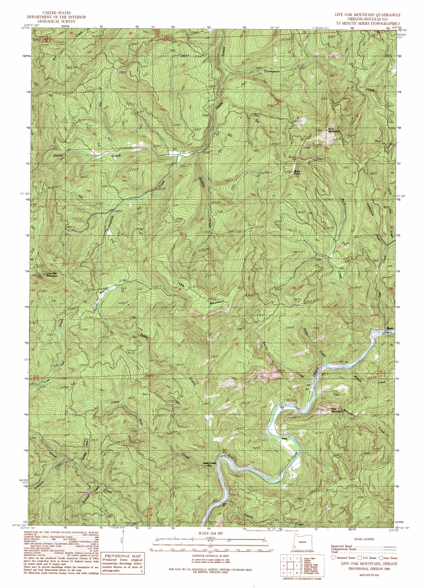
USGS Topo Quad 42123h5 - 1:24,000 scale
| Topo Map Name: | Live Oak Mountain |
| USGS Topo Quad ID: | 42123h5 |
| Print Size: | ca. 21 1/4" wide x 27" high |
| Southeast Coordinates: | 42.875° N latitude / 123.5° W longitude |
| Map Center Coordinates: | 42.9375° N latitude / 123.5625° W longitude |
| U.S. State: | OR |
| Filename: | o42123h5.jpg |
| Download Map JPG Image: | Live Oak Mountain topo map 1:24,000 scale |
| Map Type: | Topographic |
| Topo Series: | 7.5´ |
| Map Scale: | 1:24,000 |
| Source of Map Images: | United States Geological Survey (USGS) |
| Alternate Map Versions: |
Live Oak Mountain OR 1990, updated 1990 Download PDF Buy paper map Live Oak Mountain OR 2011 Download PDF Buy paper map Live Oak Mountain OR 2014 Download PDF Buy paper map |
1:24,000 Topo Quads surrounding Live Oak Mountain
Sitkum |
Mount Gurney |
Reston |
Roseburg West |
Roseburg East |
Kenyon Mountain |
Camas Valley |
Tenmile |
Winston |
Myrtle Creek |
Bone Mountain |
Chipmunk Ridge |
Live Oak Mountain |
Nickel Mountain |
Canyonville |
Mount Bolivar |
Dutchman Butte |
Rabbit Mountain |
Mccullough Creek |
Quines Creek |
Kelsey Peak |
Bunker Creek |
Mount Reuben |
Glendale |
Golden |
> Back to 42123e1 at 1:100,000 scale
> Back to 42122a1 at 1:250,000 scale
> Back to U.S. Topo Maps home
Live Oak Mountain topo map: Gazetteer
Live Oak Mountain: Flats
Horse Prairie elevation 755m 2477′Live Oak Mountain: Pillars
Buck Rock elevation 839m 2752′Live Oak Mountain: Populated Places
Dads Creek elevation 267m 875′Live Oak Mountain: Post Offices
Azalea Post Office (historical) elevation 254m 833′Nichols Post Office (historical) elevation 254m 833′
Peck Post Office (historical) elevation 251m 823′
Live Oak Mountain: Streams
Buck Creek elevation 238m 780′Cattle Creek elevation 279m 915′
Cookhouse Creek elevation 398m 1305′
Doe Creek elevation 232m 761′
Dribble Creek elevation 391m 1282′
Iron Mountain Creek elevation 246m 807′
Little Dads Creek elevation 267m 875′
Minnie Creek elevation 245m 803′
Polan Creek elevation 245m 803′
Smith Creek elevation 238m 780′
Staircase Creek elevation 389m 1276′
Table Creek elevation 268m 879′
Thompson Creek elevation 290m 951′
Wildcat Creek elevation 376m 1233′
Willingham Creek elevation 383m 1256′
Live Oak Mountain: Summits
Buck Mountain elevation 843m 2765′Iron Mountain elevation 501m 1643′
Live Oak Mountain elevation 1040m 3412′
Table Mountain elevation 1019m 3343′
Live Oak Mountain digital topo map on disk
Buy this Live Oak Mountain topo map showing relief, roads, GPS coordinates and other geographical features, as a high-resolution digital map file on DVD: