Williams Prairie Topo Map Oregon
To zoom in, hover over the map of Williams Prairie
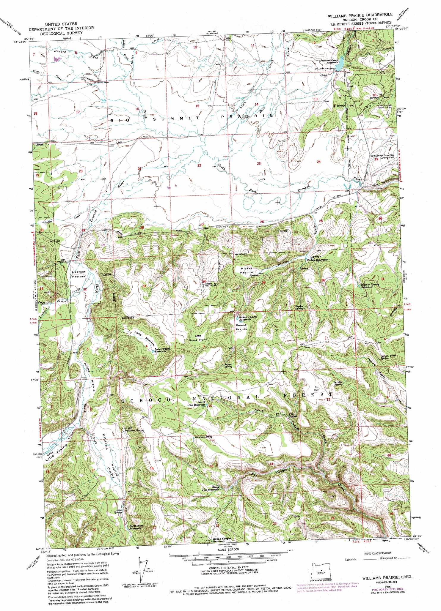
USGS Topo Quad 44120c2 - 1:24,000 scale
| Topo Map Name: | Williams Prairie |
| USGS Topo Quad ID: | 44120c2 |
| Print Size: | ca. 21 1/4" wide x 27" high |
| Southeast Coordinates: | 44.25° N latitude / 120.125° W longitude |
| Map Center Coordinates: | 44.3125° N latitude / 120.1875° W longitude |
| U.S. State: | OR |
| Filename: | o44120c2.jpg |
| Download Map JPG Image: | Williams Prairie topo map 1:24,000 scale |
| Map Type: | Topographic |
| Topo Series: | 7.5´ |
| Map Scale: | 1:24,000 |
| Source of Map Images: | United States Geological Survey (USGS) |
| Alternate Map Versions: |
Williams Prairie OR 1965, updated 1967 Download PDF Buy paper map Williams Prairie OR 1965, updated 1985 Download PDF Buy paper map Williams Prairie OR 1992, updated 1997 Download PDF Buy paper map Williams Prairie OR 2011 Download PDF Buy paper map Williams Prairie OR 2014 Download PDF Buy paper map |
| FStopo: | US Forest Service topo Williams Prairie is available: Download FStopo PDF Download FStopo TIF |
1:24,000 Topo Quads surrounding Williams Prairie
Stephenson Mountain |
Lawson Mountain |
Mitchell |
Keyes Mountain |
Frog Hollow |
Whistler Point |
Ochoco Butte |
Mount Pisgah |
Peterson Point |
Derr Meadows |
Gerow Butte |
Lookout Mountain |
Williams Prairie |
Keys Creek |
Little Summit Prairie |
Post |
Prairie Hill |
Committee Creek |
Rabbit Valley |
Paulina |
Mule Deer Ridge |
Drake Butte |
Arrowwood Point |
Liggett Table |
Maupin Butte |
> Back to 44120a1 at 1:100,000 scale
> Back to 44120a1 at 1:250,000 scale
> Back to U.S. Topo Maps home
Williams Prairie topo map: Gazetteer
Williams Prairie: Airports
Cold Spring Guard Station Landing Field elevation 1405m 4609′Williams Prairie: Canals
Gill Ditch elevation 1388m 4553′Williams Prairie: Dams
Peterson Creek Dam elevation 1411m 4629′Williams Prairie: Flats
Antler Prairie elevation 1416m 4645′Big Summit Prairie elevation 1371m 4498′
Hickey Meadow elevation 1427m 4681′
Little Round Prairie elevation 1505m 4937′
Long Prairie elevation 1468m 4816′
Lookout Pasture elevation 1399m 4589′
Lytle Prairie elevation 1440m 4724′
Round Prairie elevation 1468m 4816′
Williams Prairie elevation 1441m 4727′
Williams Prairie: Post Offices
Crescent Post Office (historical) elevation 1364m 4475′Meadow Post Office (historical) elevation 1409m 4622′
Williams Prairie: Reservoirs
Bruner Spring Reservoir elevation 1451m 4760′Faith Reservoir elevation 1416m 4645′
Fox Reservoir elevation 1530m 5019′
Gill Reservoir elevation 1376m 4514′
Hickey Reservoir elevation 1394m 4573′
Hope Reservoir elevation 1470m 4822′
Long Prairie Reservoir elevation 1471m 4826′
Lucky Reservoir elevation 1449m 4753′
North Fork Reservoir elevation 1467m 4812′
Peterson Creek Reservoir elevation 1411m 4629′
Rough Canyon Reservoir elevation 1531m 5022′
Round Prairie Reservoir elevation 1467m 4812′
Shovel Reservoir elevation 1515m 4970′
South Fox Reservoir elevation 1472m 4829′
Williams Prairie: Springs
Aspen Spring elevation 1495m 4904′Berkley Spring elevation 1483m 4865′
Bruner Spring elevation 1455m 4773′
Cold Springs elevation 1430m 4691′
Cold Springs elevation 1432m 4698′
Dingus Spring elevation 1537m 5042′
Fox Spring elevation 1463m 4799′
Hellebore Spring elevation 1538m 5045′
Indian Trail Spring elevation 1492m 4895′
Sera Spring elevation 1460m 4790′
Snyder Spring elevation 1481m 4858′
Williams Spring elevation 1458m 4783′
Williams Prairie: Streams
Allen Creek elevation 1369m 4491′Brush Creek elevation 1370m 4494′
Cram Creek elevation 1375m 4511′
Dudley Creek elevation 1379m 4524′
Elliot Creek elevation 1372m 4501′
Gray Creek elevation 1429m 4688′
Hickey Creek elevation 1363m 4471′
Howard Creek elevation 1372m 4501′
Indian Creek elevation 1373m 4504′
Johnson Creek elevation 1368m 4488′
Jungle Creek elevation 1428m 4685′
Lookout Creek elevation 1394m 4573′
North Fox Canyon Creek elevation 1383m 4537′
Peterson Creek elevation 1369m 4491′
Ross Creek elevation 1367m 4484′
Williams Prairie digital topo map on disk
Buy this Williams Prairie topo map showing relief, roads, GPS coordinates and other geographical features, as a high-resolution digital map file on DVD: