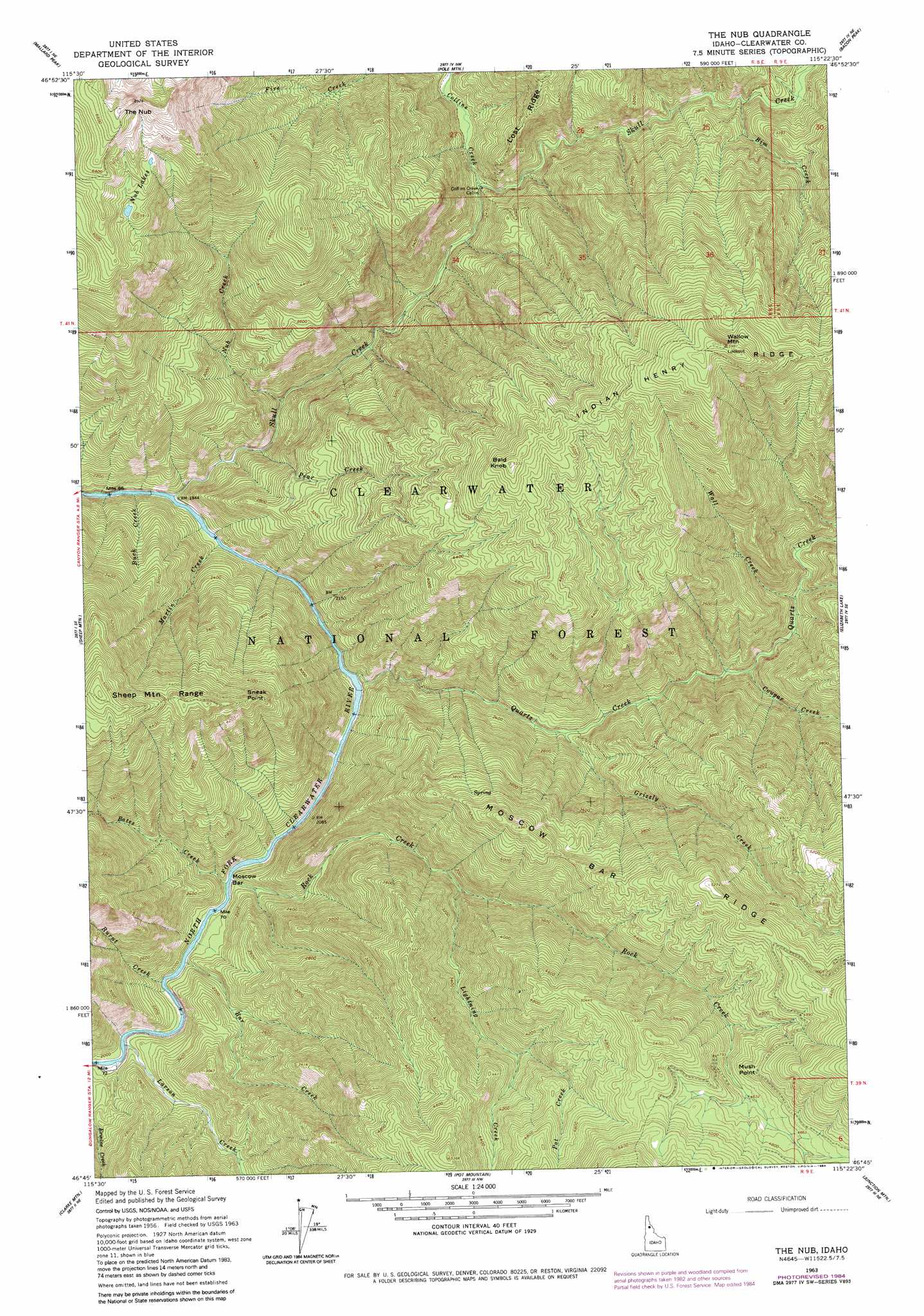
The Nub Topo Map Idaho
To zoom in, hover over the map of The Nub
USGS Topo Quad 46115g4 - 1:24,000 scale
| Topo Map Name: | The Nub |
| USGS Topo Quad ID: | 46115g4 |
| Print Size: | ca. 21 1/4" wide x 27" high |
| Southeast Coordinates: | 46.75° N latitude / 115.375° W longitude |
| Map Center Coordinates: | 46.8125° N latitude / 115.4375° W longitude |
| U.S. State: | ID |
| Filename: | o46115g4.jpg |
| Download Map JPG Image: | The Nub topo map 1:24,000 scale |
| Map Type: | Topographic |
| Topo Series: | 7.5´ |
| Map Scale: | 1:24,000 |
| Source of Map Images: | United States Geological Survey (USGS) |
| Alternate Map Versions: |
The Nub ID 1963, updated 1964 Download PDF Buy paper map The Nub ID 1963, updated 1984 Download PDF Buy paper map The Nub ID 1994, updated 1997 Download PDF Buy paper map The Nub ID 2011 Download PDF Buy paper map The Nub ID 2013 Download PDF Buy paper map |
| FStopo: | US Forest Service topo The Nub is available: Download FStopo PDF Download FStopo TIF |
1:24,000 Topo Quads surrounding The Nub
Montana Peak |
Bathtub Mountain |
Peggy Peak |
Red Ives Peak |
Sherlock Peak |
Buzzard Roost |
Mallard Peak |
Pole Mountain |
Bacon Peak |
Chamberlain Mountain |
Thompson Point |
Sheep Mountain |
The Nub |
Elizabeth Lake |
Moose Mountain |
Browns Rock |
Clarke Mountain |
Pot Mountain |
Junction Mountain |
Scurvy Mountain |
French Mountain |
Larch Butte |
Lean-To Point |
Cook Mountain |
Lookout Peak |
> Back to 46115e1 at 1:100,000 scale
> Back to 46114a1 at 1:250,000 scale
> Back to U.S. Topo Maps home
The Nub topo map: Gazetteer
The Nub: Bars
Moscow Bar elevation 606m 1988′The Nub: Capes
Mush Point elevation 1516m 4973′The Nub: Lakes
Nub Lakes elevation 1763m 5784′The Nub: Pillars
Sneak Point elevation 1289m 4229′The Nub: Ridges
Moscow Bar Ridge elevation 1565m 5134′The Nub: Streams
Bar Creek elevation 583m 1912′Bates Creek elevation 609m 1998′
Bim Creek elevation 824m 2703′
Buck Creek elevation 570m 1870′
Burnt Creek elevation 627m 2057′
Collins Creek elevation 734m 2408′
Cougar Creek elevation 791m 2595′
Grizzly Creek elevation 703m 2306′
Larson Creek elevation 595m 1952′
Lightning Creek elevation 838m 2749′
Martin Creek elevation 554m 1817′
Nub Creek elevation 618m 2027′
Pear Creek elevation 604m 1981′
Pot Creek elevation 1147m 3763′
Quartz Creek elevation 619m 2030′
Rock Creek elevation 580m 1902′
Skull Creek elevation 591m 1938′
Wall Creek elevation 764m 2506′
The Nub: Summits
Bald Knob elevation 1591m 5219′The Nub elevation 1995m 6545′
Wallow Mountain elevation 1740m 5708′
The Nub digital topo map on disk
Buy this The Nub topo map showing relief, roads, GPS coordinates and other geographical features, as a high-resolution digital map file on DVD: