Rolesville Topo Map North Carolina
To zoom in, hover over the map of Rolesville
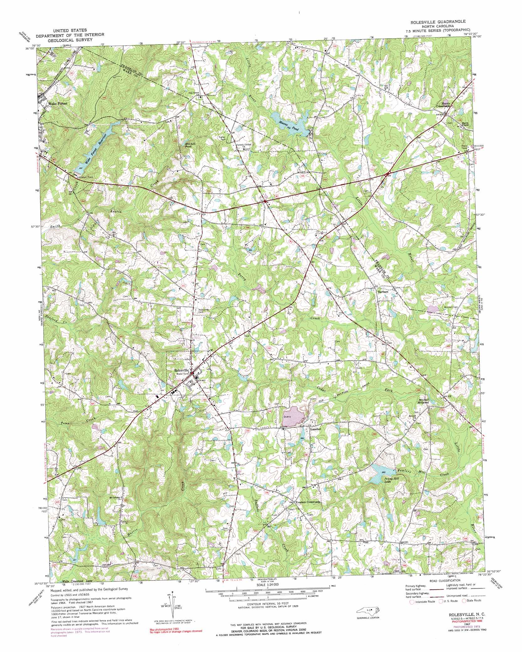
USGS Topo Quad 35078h4 - 1:24,000 scale
| Topo Map Name: | Rolesville |
| USGS Topo Quad ID: | 35078h4 |
| Print Size: | ca. 21 1/4" wide x 27" high |
| Southeast Coordinates: | 35.875° N latitude / 78.375° W longitude |
| Map Center Coordinates: | 35.9375° N latitude / 78.4375° W longitude |
| U.S. State: | NC |
| Filename: | o35078h4.jpg |
| Download Map JPG Image: | Rolesville topo map 1:24,000 scale |
| Map Type: | Topographic |
| Topo Series: | 7.5´ |
| Map Scale: | 1:24,000 |
| Source of Map Images: | United States Geological Survey (USGS) |
| Alternate Map Versions: |
Rolesville NC 1967, updated 1972 Download PDF Buy paper map Rolesville NC 1967, updated 1975 Download PDF Buy paper map Rolesville NC 1967, updated 1990 Download PDF Buy paper map Rolesville NC 1993, updated 1999 Download PDF Buy paper map Rolesville NC 2010 Download PDF Buy paper map Rolesville NC 2013 Download PDF Buy paper map Rolesville NC 2016 Download PDF Buy paper map |
1:24,000 Topo Quads surrounding Rolesville
Stem |
Wilton |
Kittrell |
Ingleside |
Gold Sand |
Creedmoor |
Grissom |
Franklinton |
Louisburg |
Justice |
Bayleaf |
Wake Forest |
Rolesville |
Bunn West |
Bunn East |
Raleigh West |
Raleigh East |
Knightdale |
Zebulon |
Middlesex |
Lake Wheeler |
Garner |
Clayton |
Flowers |
Stancils Chapel |
> Back to 35078e1 at 1:100,000 scale
> Back to 35078a1 at 1:250,000 scale
> Back to U.S. Topo Maps home
Rolesville topo map: Gazetteer
Rolesville: Dams
Blackley Pond Dam elevation 73m 239′Mitchell Pond Dam elevation 91m 298′
Moores Pond Dam elevation 106m 347′
Penny Hill Lake Dam elevation 85m 278′
Shearon Lake Dam elevation 108m 354′
Wake Forest Municipal Dam elevation 90m 295′
Watkins Pond Dam elevation 67m 219′
Rolesville: Populated Places
Barham elevation 112m 367′Fowlers Crossroads elevation 123m 403′
Harris Crossroads elevation 123m 403′
Lassiter elevation 114m 374′
Rolesville elevation 135m 442′
Rolesville: Post Offices
Rolesville Post Office elevation 135m 442′Rolesville: Reservoirs
Blackley Pond elevation 73m 239′Mitchell Millpond elevation 83m 272′
Mitchell Pond elevation 91m 298′
Mitchell Pond elevation 101m 331′
Moores Pond elevation 107m 351′
Penny Hill Lake elevation 85m 278′
Shearon Lake elevation 108m 354′
Wake Forest Reservoir elevation 90m 295′
Watkins Pond elevation 67m 219′
Rolesville: Streams
Austin Creek elevation 74m 242′Cedar Fork elevation 85m 278′
Fowlers Mill Creek elevation 78m 255′
Perry Creek elevation 95m 311′
Rolesville digital topo map on disk
Buy this Rolesville topo map showing relief, roads, GPS coordinates and other geographical features, as a high-resolution digital map file on DVD:
South Carolina, Western North Carolina & Northeastern Georgia
Buy digital topo maps: South Carolina, Western North Carolina & Northeastern Georgia