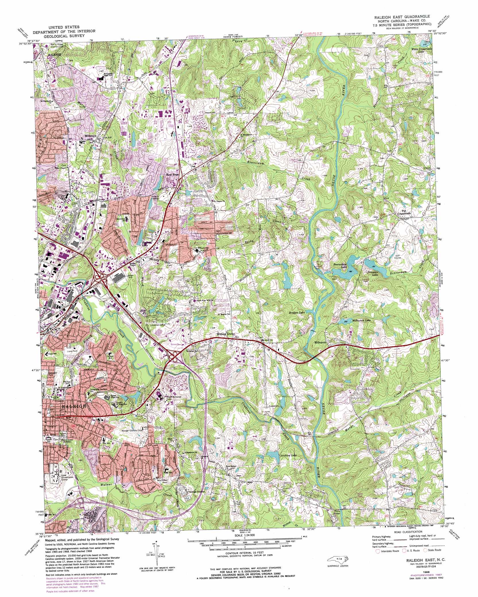
Raleigh East Topo Map North Carolina
To zoom in, hover over the map of Raleigh East
USGS Topo Quad 35078g5 - 1:24,000 scale
| Topo Map Name: | Raleigh East |
| USGS Topo Quad ID: | 35078g5 |
| Print Size: | ca. 21 1/4" wide x 27" high |
| Southeast Coordinates: | 35.75° N latitude / 78.5° W longitude |
| Map Center Coordinates: | 35.8125° N latitude / 78.5625° W longitude |
| U.S. State: | NC |
| Filename: | o35078g5.jpg |
| Download Map JPG Image: | Raleigh East topo map 1:24,000 scale |
| Map Type: | Topographic |
| Topo Series: | 7.5´ |
| Map Scale: | 1:24,000 |
| Source of Map Images: | United States Geological Survey (USGS) |
| Alternate Map Versions: |
Raleigh East NC 1968, updated 1972 Download PDF Buy paper map Raleigh East NC 1968, updated 1976 Download PDF Buy paper map Raleigh East NC 1968, updated 1982 Download PDF Buy paper map Raleigh East NC 1968, updated 1987 Download PDF Buy paper map Raleigh East NC 1993, updated 1998 Download PDF Buy paper map Raleigh East NC 2010 Download PDF Buy paper map Raleigh East NC 2013 Download PDF Buy paper map Raleigh East NC 2016 Download PDF Buy paper map |
1:24,000 Topo Quads surrounding Raleigh East
Northeast Durham |
Creedmoor |
Grissom |
Franklinton |
Louisburg |
Southeast Durham |
Bayleaf |
Wake Forest |
Rolesville |
Bunn West |
Cary |
Raleigh West |
Raleigh East |
Knightdale |
Zebulon |
Apex |
Lake Wheeler |
Garner |
Clayton |
Flowers |
Fuquay-Varina |
Angier |
Edmondson |
Powhatan |
Selma |
> Back to 35078e1 at 1:100,000 scale
> Back to 35078a1 at 1:250,000 scale
> Back to U.S. Topo Maps home
Raleigh East topo map: Gazetteer
Raleigh East: Bays
Bridges Lake elevation 53m 173′Raleigh East: Bridges
Poole Bridge elevation 47m 154′Raleigh East: Crossings
Interchange 10 elevation 83m 272′Interchange 300 elevation 73m 239′
Interchange 301 elevation 65m 213′
Raleigh East: Dams
Beaverdam Lake Dam elevation 53m 173′Carolina Lake Dam elevation 55m 180′
Emily Babcock Dam elevation 62m 203′
Foxcroft Lake Dam elevation 64m 209′
Jones Lake Dam elevation 64m 209′
Longview Dam elevation 59m 193′
Milburnie Fish Club Lake Dam elevation 56m 183′
Neuseoca Lake Dam elevation 57m 187′
Northshore Lake Dam elevation 83m 272′
Rothgeb Pond Dam elevation 65m 213′
Timberlake Lower Dam elevation 66m 216′
Turfgrass Lake Number One Dam elevation 50m 164′
Turfgrass Lake Number Three Dam elevation 59m 193′
Turfgrass Lake Number Two Dam elevation 56m 183′
Wake Crossroads Lake Dam elevation 64m 209′
Woodland Pond Dam elevation 65m 213′
Raleigh East: Parks
Anderson Point Park elevation 64m 209′Lions Park elevation 82m 269′
Marsh Creek Park elevation 101m 331′
Oakwood Park elevation 82m 269′
Roberts Park elevation 96m 314′
Worthdale Park elevation 73m 239′
Raleigh East: Populated Places
Arrowood elevation 89m 291′Barclay Downs elevation 78m 255′
Beacon Lake elevation 83m 272′
Biltmore Hills elevation 81m 265′
Boushell (historical) elevation 70m 229′
Brentwood elevation 89m 291′
Brentwood Village elevation 77m 252′
Castlebrook Estates elevation 84m 275′
Cedar Hill elevation 109m 357′
Colewood Acres elevation 84m 275′
Country Club View elevation 94m 308′
Eagle Chase elevation 61m 200′
Eastgate elevation 90m 295′
Eastwood elevation 78m 255′
El Camino Estates elevation 86m 282′
Falls Church elevation 107m 351′
Fox Run elevation 102m 334′
Foxcroft elevation 86m 282′
Golden Forest elevation 71m 232′
Greenwood Farms elevation 99m 324′
Hearthstone elevation 103m 337′
Heatherbrook elevation 87m 285′
Hickory Hollow elevation 94m 308′
Hickory Meadows elevation 72m 236′
Litchford Forest elevation 109m 357′
Lockwood elevation 73m 239′
Longview elevation 91m 298′
Lynwood Estates elevation 77m 252′
Maplewood Forest elevation 79m 259′
Milburnie elevation 80m 262′
Millbrook elevation 100m 328′
Millbrook Estates elevation 101m 331′
New Hope elevation 97m 318′
New Hope Acres elevation 102m 334′
North Shore elevation 93m 305′
Oak Forest Estates elevation 105m 344′
Oakmount elevation 103m 337′
Oakview elevation 92m 301′
Pecan Acres elevation 92m 301′
Pepperdyne elevation 91m 298′
Pet Crossroads elevation 80m 262′
Pinecrest Park elevation 88m 288′
Quail Hollow elevation 103m 337′
Quail Meadow elevation 107m 351′
Quail Ridge elevation 106m 347′
Queen Pines elevation 92m 301′
Riverview North elevation 59m 193′
Rochester Heights elevation 65m 213′
Rollingwood elevation 65m 213′
Rosemont Gardens elevation 76m 249′
Sherwood Forest elevation 92m 301′
Skycrest Village elevation 65m 213′
Southgate elevation 74m 242′
Starmount elevation 97m 318′
Stony Brook North elevation 70m 229′
Stratford Park elevation 72m 236′
Summit Ridge elevation 102m 334′
Timberlake elevation 65m 213′
Waco Heights elevation 100m 328′
Wakeview elevation 133m 436′
Walden Woods elevation 88m 288′
Washington Square elevation 99m 324′
Wilders Grove elevation 93m 305′
Will-O-Dean Acres elevation 90m 295′
Willow Creek elevation 65m 213′
Winter Park elevation 88m 288′
Woodcrest elevation 69m 226′
Woods Creek elevation 67m 219′
Raleigh East: Post Offices
Brentwood Post Office elevation 72m 236′Creekside Post Office elevation 81m 265′
Millbrook Post Office elevation 88m 288′
Neuse Post Office elevation 95m 311′
Sunnybrook Post Office elevation 76m 249′
Raleigh East: Reservoirs
Beaman Lake elevation 65m 213′Beaverdam Lake elevation 53m 173′
Carolina Lake elevation 55m 180′
Emily Babcock Lake elevation 62m 203′
Foxcroft Lake elevation 64m 209′
Jones Lake elevation 64m 209′
Milburnie Lake elevation 56m 183′
Neuseoco Lake elevation 57m 187′
Northshore Lake elevation 83m 272′
Peus Pond elevation 59m 193′
Rothgeb Pond elevation 65m 213′
Timberlake Lower Lake elevation 66m 216′
Turfgrass Lake Number One elevation 50m 164′
Turfgrass Lake Number Three elevation 59m 193′
Turfgrass Lake Number Two elevation 56m 183′
Wake Crossroads Lake elevation 64m 209′
Woodland Pond elevation 65m 213′
Raleigh East: Streams
Beaverdam Creek elevation 54m 177′Beaverdam Creek elevation 53m 173′
Big Branch elevation 82m 269′
Bridges Branch elevation 60m 196′
Cemetery Branch elevation 65m 213′
Crabtree Creek elevation 48m 157′
Harris Creek elevation 53m 173′
Hodges Mill Creek elevation 56m 183′
Mango Creek elevation 50m 164′
Marsh Creek elevation 53m 173′
Pigeon House Branch elevation 58m 190′
Rocky Creek elevation 55m 180′
Walnut Creek elevation 46m 150′
Raleigh East digital topo map on disk
Buy this Raleigh East topo map showing relief, roads, GPS coordinates and other geographical features, as a high-resolution digital map file on DVD:
South Carolina, Western North Carolina & Northeastern Georgia
Buy digital topo maps: South Carolina, Western North Carolina & Northeastern Georgia