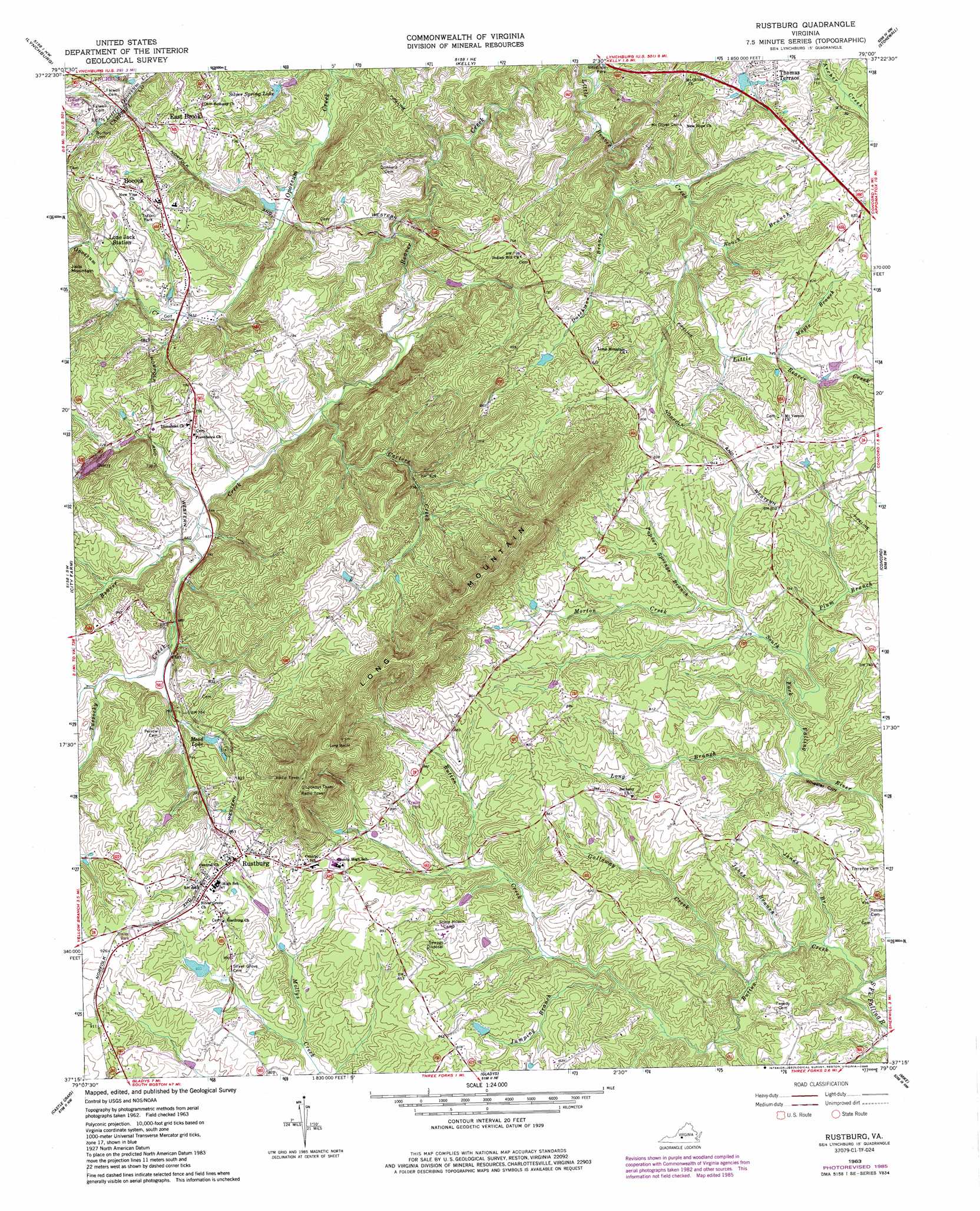
Rustburg Topo Map Virginia
To zoom in, hover over the map of Rustburg
USGS Topo Quad 37079c1 - 1:24,000 scale
| Topo Map Name: | Rustburg |
| USGS Topo Quad ID: | 37079c1 |
| Print Size: | ca. 21 1/4" wide x 27" high |
| Southeast Coordinates: | 37.25° N latitude / 79° W longitude |
| Map Center Coordinates: | 37.3125° N latitude / 79.0625° W longitude |
| U.S. State: | VA |
| Filename: | o37079c1.jpg |
| Download Map JPG Image: | Rustburg topo map 1:24,000 scale |
| Map Type: | Topographic |
| Topo Series: | 7.5´ |
| Map Scale: | 1:24,000 |
| Source of Map Images: | United States Geological Survey (USGS) |
| Alternate Map Versions: |
Rustburg VA 1963, updated 1965 Download PDF Buy paper map Rustburg VA 1963, updated 1979 Download PDF Buy paper map Rustburg VA 1963, updated 1986 Download PDF Buy paper map Rustburg VA 1963, updated 1986 Download PDF Buy paper map Rustburg VA 2010 Download PDF Buy paper map Rustburg VA 2013 Download PDF Buy paper map Rustburg VA 2016 Download PDF Buy paper map |
1:24,000 Topo Quads surrounding Rustburg
Big Island |
Tobacco Row Mountain |
Amherst |
Buffalo Ridge |
Gladstone |
Boonsboro |
Lynchburg |
Kelly |
Stonewall |
Vera |
Forest |
City Farm |
Rustburg |
Concord |
Appomattox |
Lynch Station |
Castle Craig |
Gladys |
Mike |
Red House |
Altavista |
Straightstone |
Long Island |
Brookneal |
Aspen |
> Back to 37079a1 at 1:100,000 scale
> Back to 37078a1 at 1:250,000 scale
> Back to U.S. Topo Maps home
Rustburg topo map: Gazetteer
Rustburg: Airports
Breezy Knoll Airport elevation 237m 777′Rustburg: Cliffs
Wheeler Cliff elevation 187m 613′Rustburg: Dams
Hall Dam elevation 195m 639′Lynch Dam elevation 225m 738′
Patrick Lower Dam elevation 239m 784′
Patrick Upper Dam elevation 255m 836′
Silver Spring Lake Dam elevation 180m 590′
Thomas Dam elevation 203m 666′
Rustburg: Populated Places
Bocock elevation 239m 784′East Brook elevation 233m 764′
Long Mountain Estates elevation 276m 905′
Rustburg elevation 269m 882′
Thomas Terrace elevation 224m 734′
Rustburg: Reservoirs
Lynch Lake elevation 225m 738′Mead Lake elevation 226m 741′
Silver Spring Lake elevation 180m 590′
Rustburg: Streams
Buttom Creek elevation 170m 557′Carters Creek elevation 188m 616′
Dutchman Branch elevation 184m 603′
Galloway Creek elevation 179m 587′
Jobes Branch elevation 175m 574′
Jones Branch elevation 174m 570′
Jumping Branch elevation 199m 652′
Long Branch elevation 188m 616′
Maple Branch elevation 218m 715′
Morton Creek elevation 207m 679′
Plum Branch elevation 198m 649′
Poplar Springs Branch elevation 211m 692′
Roach Branch elevation 201m 659′
Tussocky Creek elevation 194m 636′
Rustburg: Summits
Long Mountain elevation 430m 1410′Rustburg digital topo map on disk
Buy this Rustburg topo map showing relief, roads, GPS coordinates and other geographical features, as a high-resolution digital map file on DVD:
Western Virginia & Southern West Virginia
Buy digital topo maps: Western Virginia & Southern West Virginia