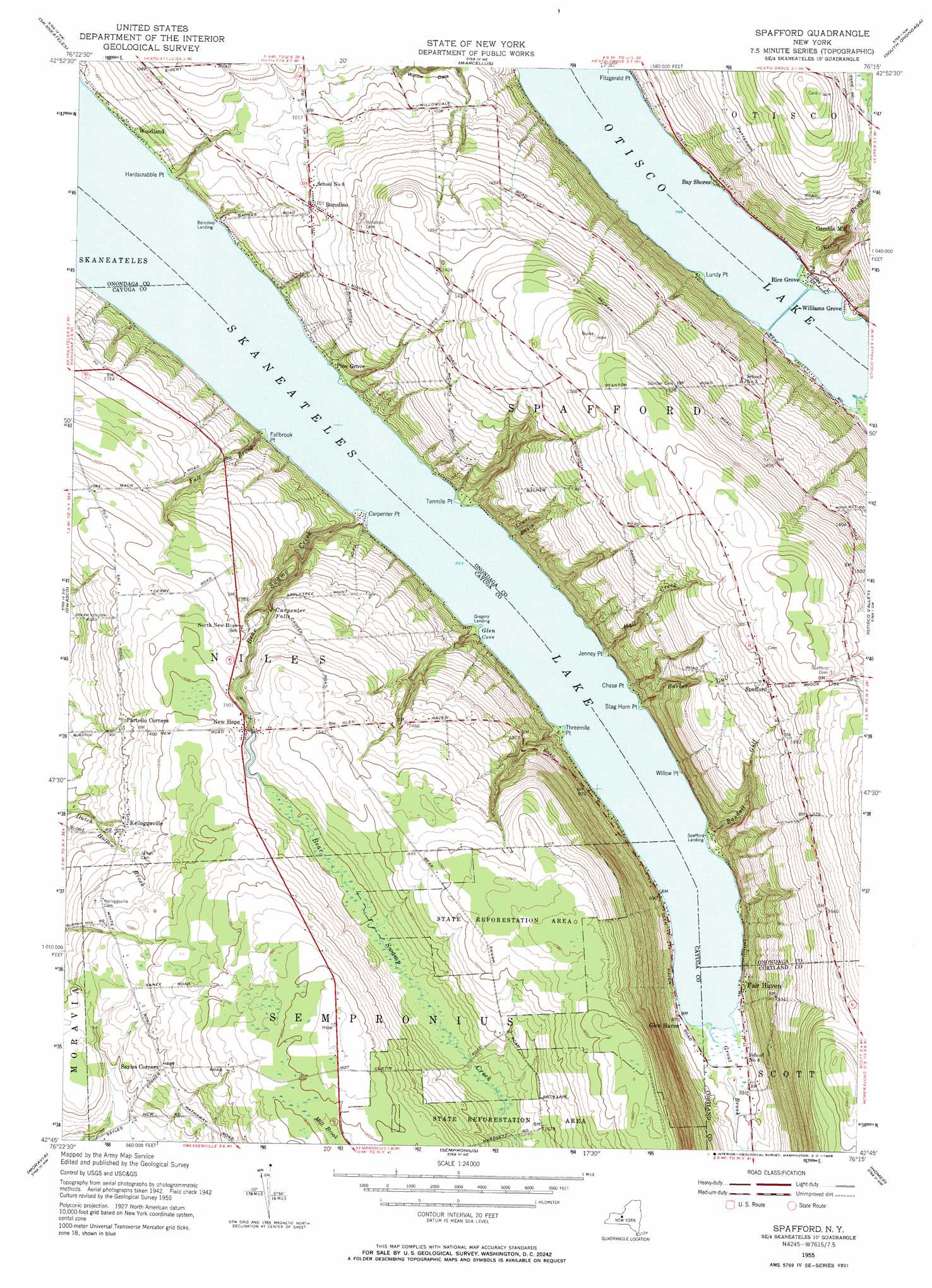
Spafford Topo Map New York
To zoom in, hover over the map of Spafford
USGS Topo Quad 42076g3 - 1:24,000 scale
| Topo Map Name: | Spafford |
| USGS Topo Quad ID: | 42076g3 |
| Print Size: | ca. 21 1/4" wide x 27" high |
| Southeast Coordinates: | 42.75° N latitude / 76.25° W longitude |
| Map Center Coordinates: | 42.8125° N latitude / 76.3125° W longitude |
| U.S. State: | NY |
| Filename: | o42076g3.jpg |
| Download Map JPG Image: | Spafford topo map 1:24,000 scale |
| Map Type: | Topographic |
| Topo Series: | 7.5´ |
| Map Scale: | 1:24,000 |
| Source of Map Images: | United States Geological Survey (USGS) |
| Alternate Map Versions: |
Spafford NY 1955, updated 1957 Download PDF Buy paper map Spafford NY 1955, updated 1968 Download PDF Buy paper map Spafford NY 2010 Download PDF Buy paper map Spafford NY 2013 Download PDF Buy paper map Spafford NY 2016 Download PDF Buy paper map |
1:24,000 Topo Quads surrounding Spafford
Weedsport |
Jordan |
Camillus |
Syracuse West |
Syracuse East |
Auburn |
Skaneateles |
Marcellus |
South Onondaga |
Jamesville |
Scipio Center |
Owasco |
Spafford |
Otisco Valley |
Tully |
Genoa |
Moravia |
Sempronius |
Homer |
Truxton |
Ludlowville |
West Groton |
Groton |
Cortland |
Mcgraw |
> Back to 42076e1 at 1:100,000 scale
> Back to 42076a1 at 1:250,000 scale
> Back to U.S. Topo Maps home
Spafford topo map: Gazetteer
Spafford: Airports
Maus Marineland Seaplane Base elevation 263m 862′Spafford: Bays
Glen Cove elevation 263m 862′Spafford: Capes
Chase Point elevation 272m 892′Fallbrook Point elevation 271m 889′
Hardscrabble Point elevation 266m 872′
Jenney Point elevation 268m 879′
Stag Horn Point elevation 266m 872′
Tenmile Point elevation 265m 869′
Threemile Point elevation 268m 879′
Willow Point elevation 265m 869′
Spafford: Falls
Carpenter Falls elevation 388m 1272′Spafford: Populated Places
Bay Shores elevation 244m 800′Borodino elevation 336m 1102′
Borodino Landing elevation 264m 866′
Fair Haven elevation 269m 882′
Gamble Mill elevation 315m 1033′
Glen Haven elevation 269m 882′
Gregory Landing elevation 270m 885′
Kelloggsville elevation 429m 1407′
New Hope elevation 464m 1522′
Partello Corners elevation 420m 1377′
Pine Grove elevation 264m 866′
Rice Grove elevation 248m 813′
Spafford elevation 514m 1686′
Spafford Landing elevation 263m 862′
Williams Grove elevation 242m 793′
Woodland elevation 269m 882′
Spafford: Streams
Barber Gulf elevation 263m 862′Bear Swamp Creek elevation 263m 862′
Fall Brook elevation 264m 866′
Grout Brook elevation 263m 862′
Hall Creek elevation 263m 862′
Lower Basin elevation 263m 862′
Randall Gulf elevation 264m 866′
Rice Brook elevation 241m 790′
Spafford digital topo map on disk
Buy this Spafford topo map showing relief, roads, GPS coordinates and other geographical features, as a high-resolution digital map file on DVD:
New York, Vermont, Connecticut & Western Massachusetts
Buy digital topo maps: New York, Vermont, Connecticut & Western Massachusetts