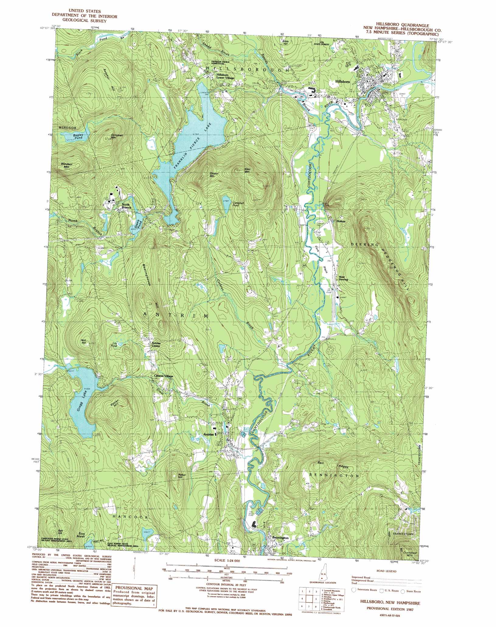
Hillsboro Topo Map New Hampshire
To zoom in, hover over the map of Hillsboro
USGS Topo Quad 43071a8 - 1:24,000 scale
| Topo Map Name: | Hillsboro |
| USGS Topo Quad ID: | 43071a8 |
| Print Size: | ca. 21 1/4" wide x 27" high |
| Southeast Coordinates: | 43° N latitude / 71.875° W longitude |
| Map Center Coordinates: | 43.0625° N latitude / 71.9375° W longitude |
| U.S. State: | NH |
| Filename: | o43071a8.jpg |
| Download Map JPG Image: | Hillsboro topo map 1:24,000 scale |
| Map Type: | Topographic |
| Topo Series: | 7.5´ |
| Map Scale: | 1:24,000 |
| Source of Map Images: | United States Geological Survey (USGS) |
| Alternate Map Versions: |
Hillsboro NH 1987, updated 1987 Download PDF Buy paper map Hillsboro NH 1995, updated 1999 Download PDF Buy paper map Hillsboro NH 2012 Download PDF Buy paper map Hillsboro NH 2015 Download PDF Buy paper map |
1:24,000 Topo Quads surrounding Hillsboro
Sunapee Lakes |
Bradford |
Warner |
Webster |
|
Washington |
Hillsboro Upper Village |
Henniker |
Hopkinton |
|
Stoddard |
Hillsboro |
Deering |
Weare |
|
Dublin |
Peterborough North |
Greenfield |
New Boston |
|
Monadnock Mountain |
Peterborough South |
Greenville |
Milford |
> Back to 43071a1 at 1:100,000 scale
> Back to 43070a1 at 1:250,000 scale
> Back to U.S. Topo Maps home
Hillsboro topo map: Gazetteer
Hillsboro: Airports
Hawthore-Feather Airpark elevation 182m 597′Hawthorne-Feather Airpark elevation 219m 718′
Hillsboro: Bridges
Great Bridge elevation 170m 557′Hillsboro-Deering Railroad Covered Bridge elevation 170m 557′
Hillsboro: Dams
Campbell Pond Dam elevation 278m 912′Gregg Lake Dam elevation 342m 1122′
Monadnock Power Station Dam elevation 201m 659′
Paper Mill Dam elevation 197m 646′
Pierce Power Dam elevation 197m 646′
Steel Pond Dam elevation 267m 875′
Hillsboro: Flats
Corkplain elevation 180m 590′Hillsboro: Lakes
Bagley Pond elevation 352m 1154′Lily Pond elevation 334m 1095′
Hillsboro: Populated Places
Antrim elevation 214m 702′Antrim Center elevation 313m 1026′
Bennington elevation 200m 656′
Clinton Village elevation 272m 892′
Hillsboro elevation 191m 626′
Hillsboro Lower Village elevation 217m 711′
Holton elevation 181m 593′
North Branch elevation 287m 941′
West Deering elevation 183m 600′
Hillsboro: Post Offices
Antrim Post Office elevation 191m 626′Bennington Post Office elevation 208m 682′
Hillsboro Post Office elevation 198m 649′
Hillsboro: Reservoirs
Campbell Pond elevation 278m 912′Contoocook River Reservoir elevation 201m 659′
Contoocook River Reservoir elevation 197m 646′
Franklin Pierce Lake elevation 236m 774′
Gregg Lake elevation 342m 1122′
Steels Pond elevation 267m 875′
Hillsboro: Ridges
Hedgehog Hill elevation 378m 1240′Hillsboro: Streams
Beard Brook elevation 183m 600′Cochran Brook elevation 182m 597′
Great Brook elevation 183m 600′
North Branch River elevation 179m 587′
Shedd Brook elevation 193m 633′
Hillsboro: Summits
Ball Hill elevation 420m 1377′Bell Ledges elevation 373m 1223′
Bible Hill elevation 260m 853′
Campbell Mountain elevation 424m 1391′
Gibson Mountain elevation 400m 1312′
Holt Hill elevation 421m 1381′
Meetinghouse Hill elevation 410m 1345′
Nahor Hill elevation 345m 1131′
Patten Hill elevation 414m 1358′
Riley Mountain elevation 442m 1450′
Sulphur Hill elevation 383m 1256′
Hillsboro: Swamps
Evas Marsh elevation 278m 912′Hillsboro digital topo map on disk
Buy this Hillsboro topo map showing relief, roads, GPS coordinates and other geographical features, as a high-resolution digital map file on DVD:
Maine, New Hampshire, Rhode Island & Eastern Massachusetts
Buy digital topo maps: Maine, New Hampshire, Rhode Island & Eastern Massachusetts