Sylvan Peak Topo Map Montana
To zoom in, hover over the map of Sylvan Peak
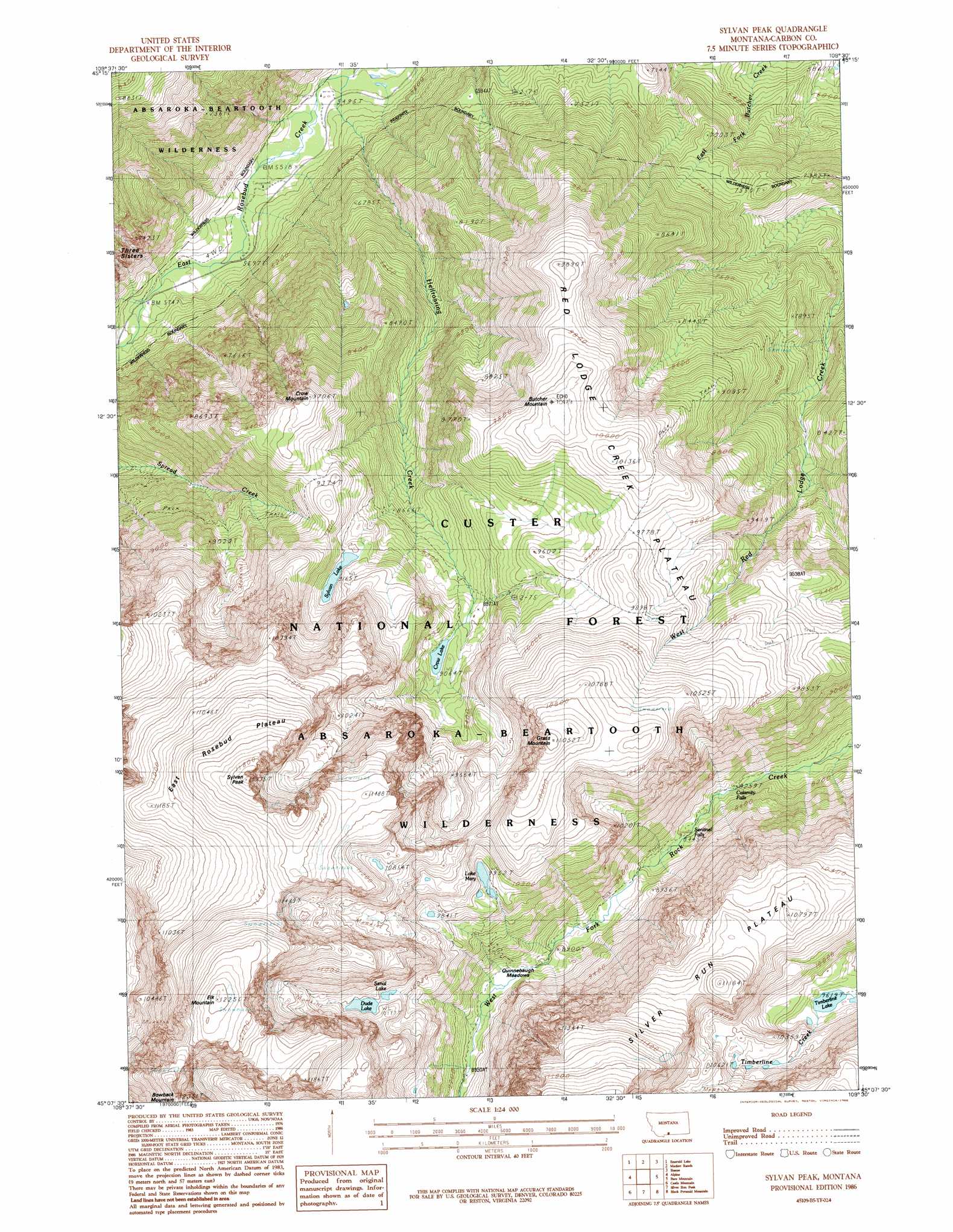
USGS Topo Quad 45109b5 - 1:24,000 scale
| Topo Map Name: | Sylvan Peak |
| USGS Topo Quad ID: | 45109b5 |
| Print Size: | ca. 21 1/4" wide x 27" high |
| Southeast Coordinates: | 45.125° N latitude / 109.5° W longitude |
| Map Center Coordinates: | 45.1875° N latitude / 109.5625° W longitude |
| U.S. State: | MT |
| Filename: | o45109b5.jpg |
| Download Map JPG Image: | Sylvan Peak topo map 1:24,000 scale |
| Map Type: | Topographic |
| Topo Series: | 7.5´ |
| Map Scale: | 1:24,000 |
| Source of Map Images: | United States Geological Survey (USGS) |
| Alternate Map Versions: |
Sylvan Peak MT 1986, updated 1986 Download PDF Buy paper map Sylvan Peak MT 1996, updated 1999 Download PDF Buy paper map Sylvan Peak MT 2011 Download PDF Buy paper map Sylvan Peak MT 2014 Download PDF Buy paper map |
| FStopo: | US Forest Service topo Sylvan Peak is available: Download FStopo PDF Download FStopo TIF |
1:24,000 Topo Quads surrounding Sylvan Peak
Nye |
Beehive |
Fishtail |
Roscoe Nw |
Roscoe Ne |
Mount Wood |
Emerald Lake |
Mackay Ranch |
Roscoe |
Castagne |
Granite Peak |
Alpine |
Sylvan Peak |
Bare Mountain |
Red Lodge West |
Fossil Lake |
Castle Mountain |
Silver Run Peak |
Black Pyramid Mountain |
Mount Maurice |
Jim Smith Peak |
Muddy Creek |
Beartooth Butte |
Deep Lake |
North Bennett Creek |
> Back to 45109a1 at 1:100,000 scale
> Back to 45108a1 at 1:250,000 scale
> Back to U.S. Topo Maps home
Sylvan Peak topo map: Gazetteer
Sylvan Peak: Falls
Calamity Falls elevation 2494m 8182′Sentinel Falls elevation 2550m 8366′
Sylvan Peak: Flats
Quinnebaugh Meadows elevation 2769m 9084′Sylvan Peak: Lakes
Crow Lake elevation 2764m 9068′Dude Lake elevation 3103m 10180′
Lake Mary elevation 3035m 9957′
Lake Sylvan elevation 2795m 9169′
Senal Lake elevation 3093m 10147′
Timberline Lake elevation 2933m 9622′
Sylvan Peak: Plains
East Rosebud Plateau elevation 3524m 11561′Red Lodge Creek Plateau elevation 3088m 10131′
Sylvan Peak: Streams
Hellroaring Creek elevation 1664m 5459′Sylvan Peak: Summits
Bowback Mountain elevation 3746m 12290′Butcher Mountain elevation 3098m 10164′
Crow Mountain elevation 2955m 9694′
Elk Mountain elevation 3727m 12227′
Grass Mountain elevation 3366m 11043′
Sylvan Peak elevation 3638m 11935′
Sylvan Peak digital topo map on disk
Buy this Sylvan Peak topo map showing relief, roads, GPS coordinates and other geographical features, as a high-resolution digital map file on DVD: