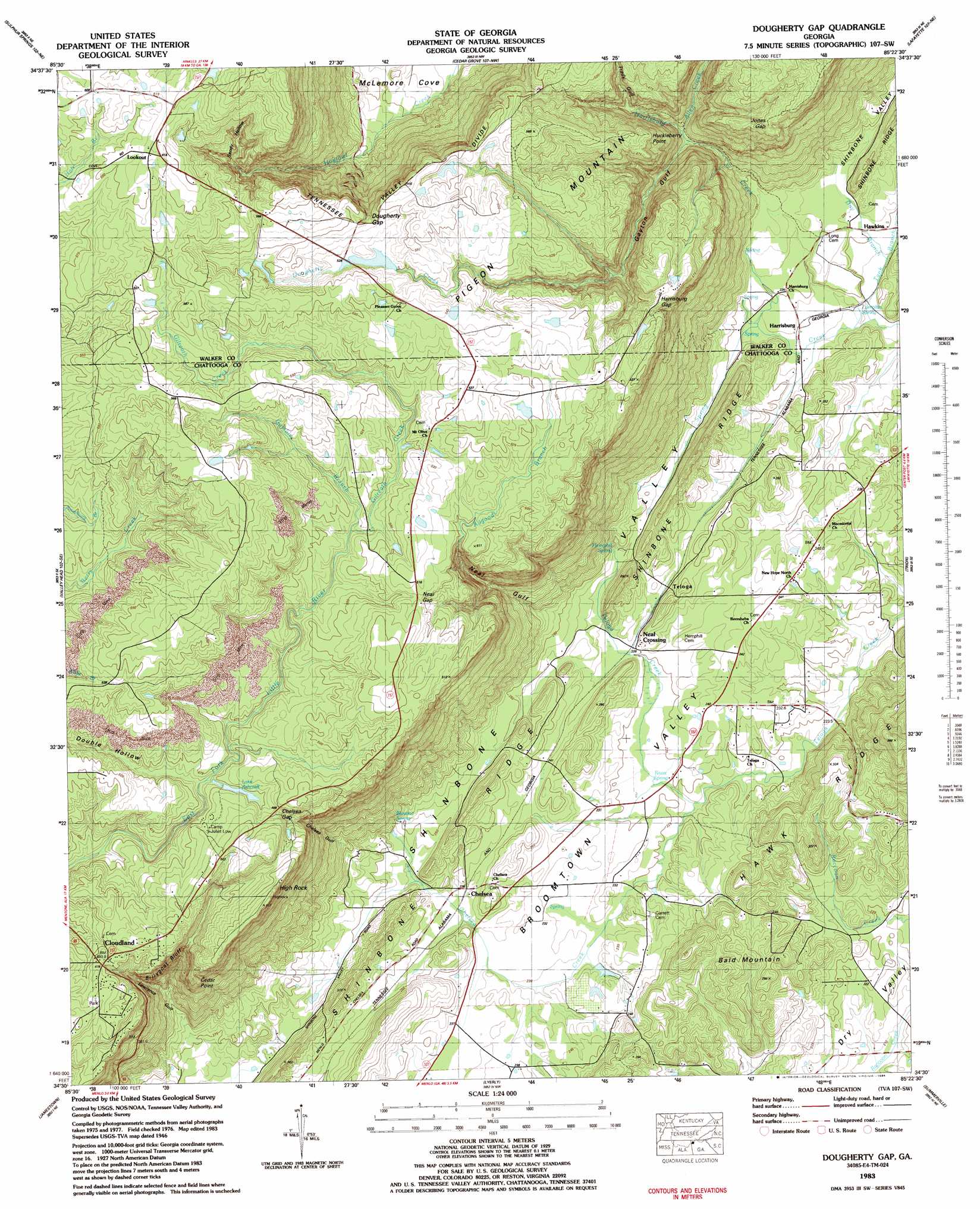
Dougherty Gap Topo Map Georgia
To zoom in, hover over the map of Dougherty Gap
USGS Topo Quad 34085e4 - 1:24,000 scale
| Topo Map Name: | Dougherty Gap |
| USGS Topo Quad ID: | 34085e4 |
| Print Size: | ca. 21 1/4" wide x 27" high |
| Southeast Coordinates: | 34.5° N latitude / 85.375° W longitude |
| Map Center Coordinates: | 34.5625° N latitude / 85.4375° W longitude |
| U.S. State: | GA |
| Filename: | o34085e4.jpg |
| Download Map JPG Image: | Dougherty Gap topo map 1:24,000 scale |
| Map Type: | Topographic |
| Topo Series: | 7.5´ |
| Map Scale: | 1:24,000 |
| Source of Map Images: | United States Geological Survey (USGS) |
| Alternate Map Versions: |
Dougherty Gap GA 1936 Download PDF Buy paper map Dougherty Gap GA 1946, updated 1964 Download PDF Buy paper map Dougherty Gap GA 1946, updated 1967 Download PDF Buy paper map Dougherty Gap GA 1947, updated 1947 Download PDF Buy paper map Dougherty Gap GA 1983, updated 1984 Download PDF Buy paper map Dougherty Gap GA 2011 Download PDF Buy paper map Dougherty Gap GA 2014 Download PDF Buy paper map |
1:24,000 Topo Quads surrounding Dougherty Gap
Flat Rock |
Trenton |
Durham |
Kensington |
Nickajack Gap |
Ider |
Sulphur Springs |
Cedar Grove |
Estelle |
Catlett |
Dugout Valley |
Valley Head |
Dougherty Gap |
Trion |
Subligna |
Fort Payne |
Jamestown |
Lyerly |
Summerville |
Armuchee |
Little River |
Gaylesville |
Chattoogaville |
Rock Mountain |
Rome North |
> Back to 34085e1 at 1:100,000 scale
> Back to 34084a1 at 1:250,000 scale
> Back to U.S. Topo Maps home
Dougherty Gap topo map: Gazetteer
Dougherty Gap: Airports
Valley View Ranch Airport elevation 541m 1774′Dougherty Gap: Bridges
McConels Bridge elevation 218m 715′Dougherty Gap: Cliffs
Huckleberry Point elevation 404m 1325′Dougherty Gap: Dams
Mountain Cove Lake Dam elevation 526m 1725′Dougherty Gap: Gaps
Dougherty Gap elevation 539m 1768′Harrisburg Gap elevation 488m 1601′
Jones Gap elevation 449m 1473′
Neal Gap elevation 506m 1660′
Dougherty Gap: Lakes
Duck Pond elevation 216m 708′Dougherty Gap: Pillars
High Rock elevation 515m 1689′Dougherty Gap: Populated Places
Broomtown (historical) elevation 224m 734′Chelsea elevation 239m 784′
Cloudland elevation 480m 1574′
Harrisburg elevation 219m 718′
Neal Crossing elevation 227m 744′
Teloga elevation 239m 784′
Dougherty Gap: Reservoirs
Mountain Cove Lake elevation 526m 1725′Dougherty Gap: Ridges
Hawk Ridge elevation 307m 1007′Dougherty Gap: Springs
Blowing Spring elevation 249m 816′Hemphill Spring elevation 240m 787′
Knox Spring elevation 222m 728′
Lumpkin Spring elevation 215m 705′
Dougherty Gap: Streams
Allen Creek elevation 331m 1085′Allgood Branch elevation 220m 721′
Chelsea Creek elevation 218m 715′
Gamble Branch elevation 484m 1587′
Gilreath Creek elevation 484m 1587′
Harrisburg Creek elevation 214m 702′
Dougherty Gap: Summits
Bald Mountain elevation 299m 980′Cedar Point elevation 471m 1545′
Gulf Mountain elevation 659m 2162′
Dougherty Gap: Valleys
Chelsea Gulf elevation 262m 859′Dougherty Gulf elevation 428m 1404′
Frady Gulf elevation 370m 1213′
Gayton Gulf elevation 307m 1007′
Harrisburg Gulf elevation 244m 800′
Lawrence Gulf elevation 281m 921′
Neal Gulf elevation 255m 836′
Sandy Hollow elevation 487m 1597′
Dougherty Gap digital topo map on disk
Buy this Dougherty Gap topo map showing relief, roads, GPS coordinates and other geographical features, as a high-resolution digital map file on DVD: