Rutland Topo Map Vermont
To zoom in, hover over the map of Rutland
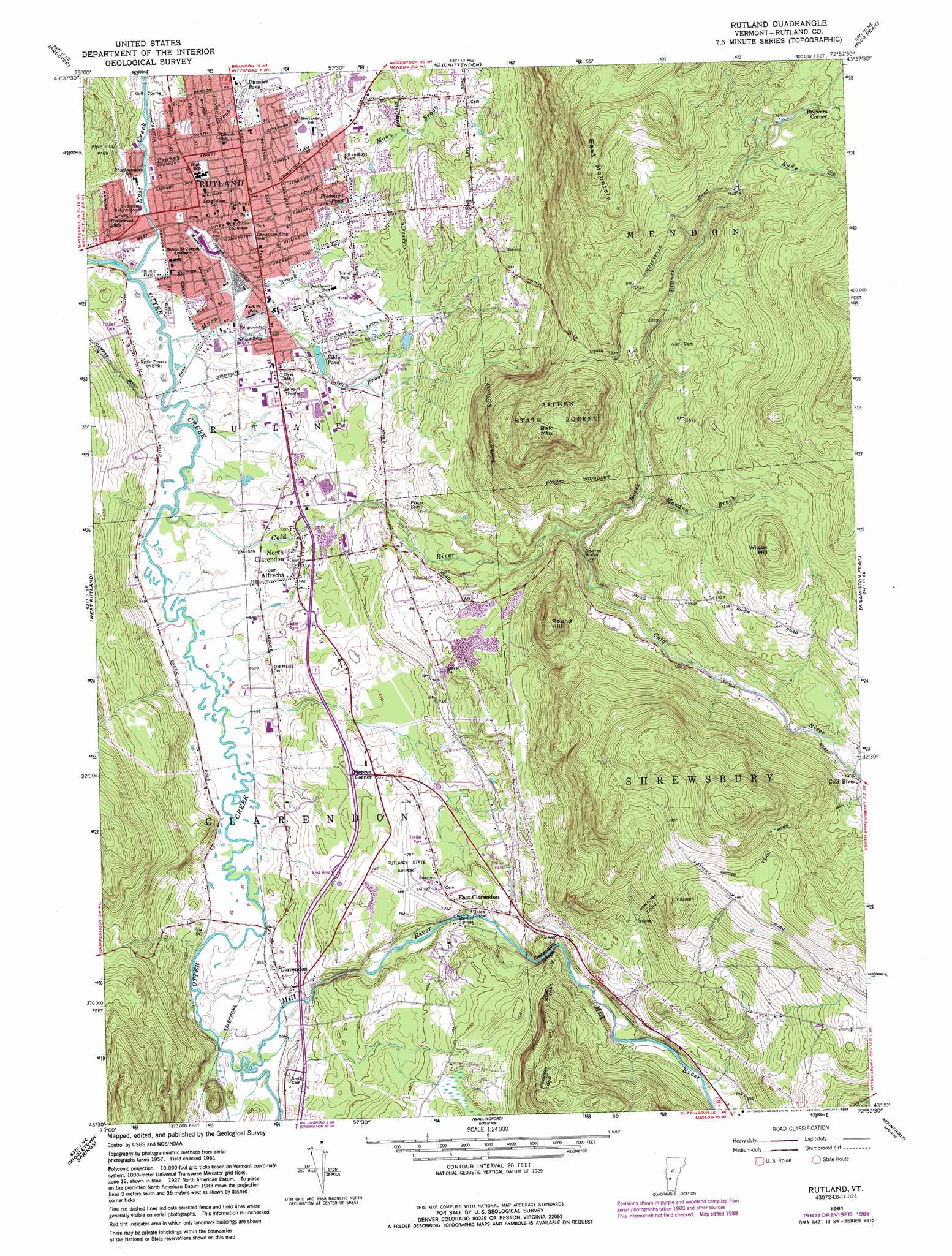
USGS Topo Quad 43072e8 - 1:24,000 scale
| Topo Map Name: | Rutland |
| USGS Topo Quad ID: | 43072e8 |
| Print Size: | ca. 21 1/4" wide x 27" high |
| Southeast Coordinates: | 43.5° N latitude / 72.875° W longitude |
| Map Center Coordinates: | 43.5625° N latitude / 72.9375° W longitude |
| U.S. State: | VT |
| Filename: | o43072e8.jpg |
| Download Map JPG Image: | Rutland topo map 1:24,000 scale |
| Map Type: | Topographic |
| Topo Series: | 7.5´ |
| Map Scale: | 1:24,000 |
| Source of Map Images: | United States Geological Survey (USGS) |
| Alternate Map Versions: |
Rutland VT 1961, updated 1964 Download PDF Buy paper map Rutland VT 1961, updated 1973 Download PDF Buy paper map Rutland VT 1961, updated 1981 Download PDF Buy paper map Rutland VT 1961, updated 1988 Download PDF Buy paper map Rutland VT 1961, updated 1988 Download PDF Buy paper map Rutland VT 1996, updated 2000 Download PDF Buy paper map Rutland VT 2012 Download PDF Buy paper map Rutland VT 2015 Download PDF Buy paper map |
| FStopo: | US Forest Service topo Rutland is available: Download FStopo PDF Download FStopo TIF |
1:24,000 Topo Quads surrounding Rutland
Sudbury |
Brandon |
Mount Carmel |
Rochester |
Bethel |
Bomoseen |
Proctor |
Chittenden |
Pico Peak |
Delectable Mountain |
Poultney |
West Rutland |
Rutland |
Killington Peak |
Plymouth |
Wells |
Middletown Springs |
Wallingford |
Mount Holly |
Ludlow |
Pawlet |
Dorset |
Danby |
Weston |
Andover |
> Back to 43072e1 at 1:100,000 scale
> Back to 43072a1 at 1:250,000 scale
> Back to U.S. Topo Maps home
Rutland topo map: Gazetteer
Rutland: Airports
Rutland State Airport elevation 239m 784′Rutland: Bridges
Brown Covered Bridge elevation 309m 1013′Kingsley Covered Bridge elevation 212m 695′
Rutland: Dams
Eddy Pond Lower Dam elevation 179m 587′Upper Eddy Pond Dam elevation 196m 643′
Rutland: Forests
Aitken State Forest elevation 600m 1968′Rutland: Lakes
Dunklee Pond elevation 182m 597′Eddy Pond elevation 178m 583′
Piedmont Pond elevation 184m 603′
Rutland: Parks
Main Street Park elevation 192m 629′Pine Hill Park elevation 243m 797′
Rutland Courthouse Historic District elevation 185m 606′
Rutland Downtown Historic District elevation 180m 590′
Whites Playground elevation 171m 561′
Rutland: Populated Places
Alfrecha elevation 170m 557′Bassett Development elevation 227m 744′
Billings Mobile Manor elevation 193m 633′
Brewers Corner elevation 544m 1784′
Brookside Trailer Park elevation 171m 561′
Brookwood Estates elevation 282m 925′
Clarendon elevation 180m 590′
Cold River elevation 416m 1364′
East Clarendon elevation 227m 744′
Eastridge Acres elevation 282m 925′
Grandview Acres elevation 258m 846′
Green Acres elevation 248m 813′
Heritage Hill Development elevation 231m 757′
Killington Heights elevation 239m 784′
Marolin Acres elevation 211m 692′
North Clarendon elevation 180m 590′
Pierces Corner elevation 217m 711′
Rutland elevation 197m 646′
Rutland: Post Offices
North Clarendeon Post Office elevation 175m 574′Rutland Post Office elevation 170m 557′
Rutland: Reservoirs
Combination Pond elevation 197m 646′Lower Eddy Pond elevation 179m 587′
Upper Eddy Pond elevation 196m 643′
Rutland: Streams
Cold River elevation 158m 518′East Creek elevation 157m 515′
Eddy Brook elevation 493m 1617′
Mendon Brook elevation 344m 1128′
Mill River elevation 163m 534′
Moon Brook elevation 158m 518′
Mussey Brook elevation 159m 521′
North Branch Cold River elevation 294m 964′
Tenney Brook elevation 164m 538′
Rutland: Summits
Bald Mountain elevation 632m 2073′East Mountain elevation 720m 2362′
Round Hill elevation 510m 1673′
Wilcox Hill elevation 630m 2066′
Rutland: Valleys
Clarendon Gorge elevation 228m 748′Rutland digital topo map on disk
Buy this Rutland topo map showing relief, roads, GPS coordinates and other geographical features, as a high-resolution digital map file on DVD:
New York, Vermont, Connecticut & Western Massachusetts
Buy digital topo maps: New York, Vermont, Connecticut & Western Massachusetts