Packwood Topo Map Washington
To zoom in, hover over the map of Packwood
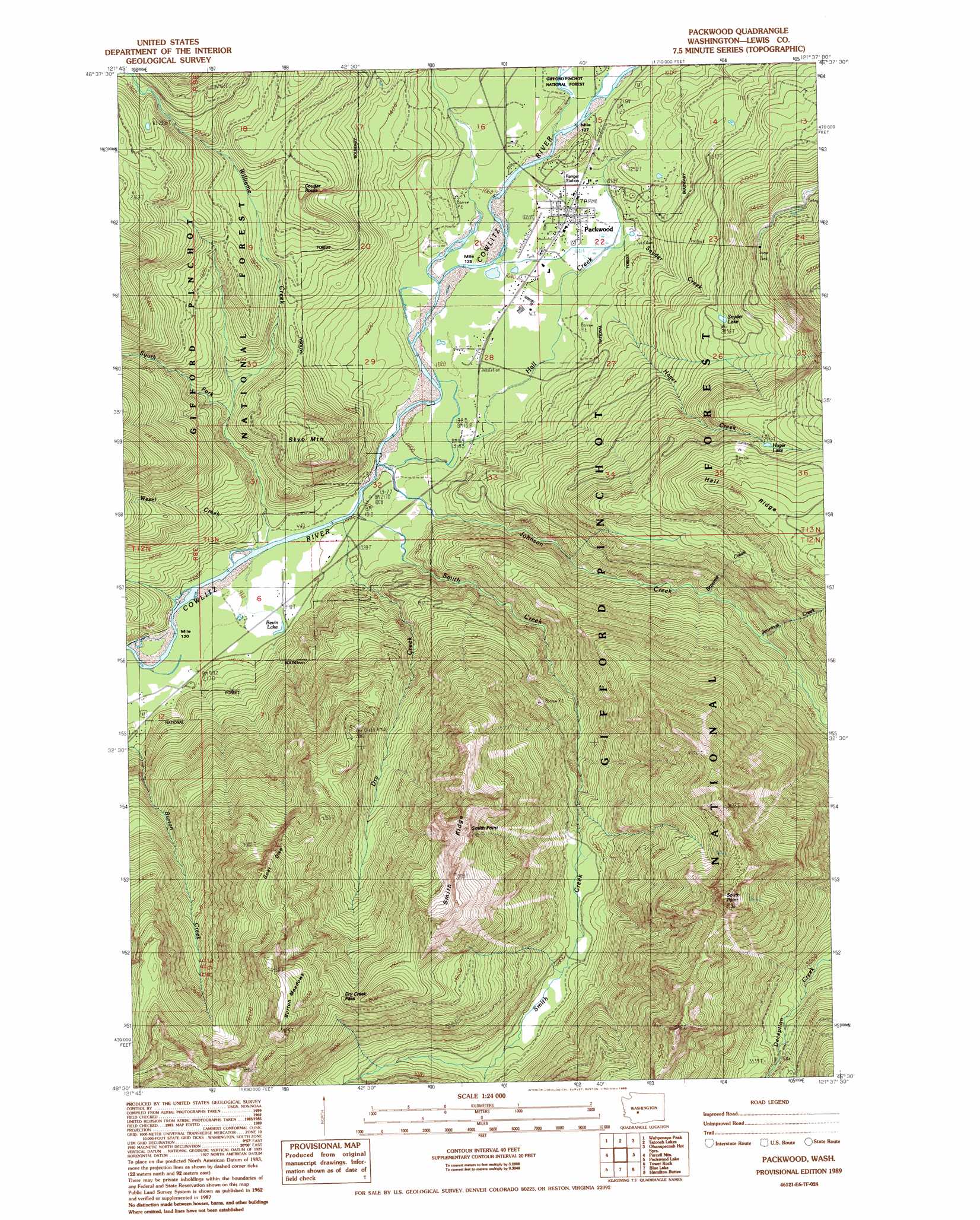
USGS Topo Quad 46121e6 - 1:24,000 scale
| Topo Map Name: | Packwood |
| USGS Topo Quad ID: | 46121e6 |
| Print Size: | ca. 21 1/4" wide x 27" high |
| Southeast Coordinates: | 46.5° N latitude / 121.625° W longitude |
| Map Center Coordinates: | 46.5625° N latitude / 121.6875° W longitude |
| U.S. State: | WA |
| Filename: | o46121e6.jpg |
| Download Map JPG Image: | Packwood topo map 1:24,000 scale |
| Map Type: | Topographic |
| Topo Series: | 7.5´ |
| Map Scale: | 1:24,000 |
| Source of Map Images: | United States Geological Survey (USGS) |
| Alternate Map Versions: |
Packwood WA 1989, updated 1989 Download PDF Buy paper map Packwood WA 1994, updated 1996 Download PDF Buy paper map Packwood WA 2011 Download PDF Buy paper map Packwood WA 2014 Download PDF Buy paper map |
| FStopo: | US Forest Service topo Packwood is available: Download FStopo PDF Download FStopo TIF |
1:24,000 Topo Quads surrounding Packwood
Mount Wow |
Mount Rainier West |
Mt Rainier East |
Chinook Pass |
Cougar Lake |
Sawtooth Ridge |
Wahpenayo Peak |
Tatoosh Lakes |
Ohanapecosh Hot Springs |
White Pass |
Randle |
Purcell Mountain |
Packwood |
Packwood Lake |
Old Snowy Mountain |
Greenhorn Buttes |
Tower Rock |
Blue Lake |
Hamilton Buttes |
Walupt Lake |
French Butte |
Mccoy Peak |
East Canyon Ridge |
Green Mountain |
Glaciate Butte |
> Back to 46121e1 at 1:100,000 scale
> Back to 46120a1 at 1:250,000 scale
> Back to U.S. Topo Maps home
Packwood topo map: Gazetteer
Packwood: Airports
Packwood Airport elevation 320m 1049′Packwood: Cliffs
Goat Dike elevation 1405m 4609′South Point elevation 1786m 5859′
Packwood: Falls
Jennings Falls elevation 676m 2217′Packwood: Flats
Burton Meadows elevation 1632m 5354′Packwood: Gaps
Dry Creek Pass elevation 1387m 4550′Packwood: Lakes
Bivin Lake elevation 305m 1000′Hager Lake elevation 898m 2946′
Snyder Lake elevation 617m 2024′
Packwood: Populated Places
Packwood elevation 321m 1053′Packwood: Ridges
Hall Ridge elevation 1102m 3615′Smith Ridge elevation 1635m 5364′
Packwood: Streams
Brownie Creek elevation 402m 1318′Dry Creek elevation 306m 1003′
Hager Creek elevation 364m 1194′
Hall Creek elevation 311m 1020′
Johnson Creek elevation 305m 1000′
Jonathan Creek elevation 324m 1062′
Skate Creek elevation 317m 1040′
Smith Creek elevation 306m 1003′
Snyder Creek elevation 320m 1049′
South Fork Willame Creek elevation 374m 1227′
Tail Race elevation 315m 1033′
Wesel Creek elevation 305m 1000′
Willame Creek elevation 299m 980′
Packwood: Summits
Cougar Rocks elevation 628m 2060′Skyo Mountain elevation 738m 2421′
Packwood: Trails
Dry Creek Trail elevation 1194m 3917′Pompey Peak Trail elevation 1581m 5187′
South Point Trail elevation 1580m 5183′
Packwood digital topo map on disk
Buy this Packwood topo map showing relief, roads, GPS coordinates and other geographical features, as a high-resolution digital map file on DVD: