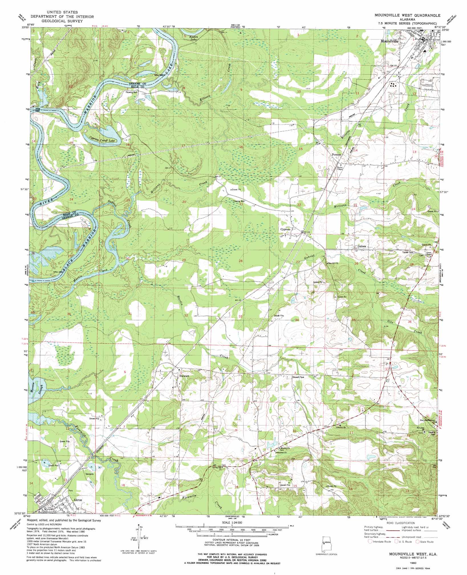
Moundville West Topo Map Alabama
To zoom in, hover over the map of Moundville West
USGS Topo Quad 32087h6 - 1:24,000 scale
| Topo Map Name: | Moundville West |
| USGS Topo Quad ID: | 32087h6 |
| Print Size: | ca. 21 1/4" wide x 27" high |
| Southeast Coordinates: | 32.875° N latitude / 87.625° W longitude |
| Map Center Coordinates: | 32.9375° N latitude / 87.6875° W longitude |
| U.S. State: | AL |
| Filename: | o32087h6.jpg |
| Download Map JPG Image: | Moundville West topo map 1:24,000 scale |
| Map Type: | Topographic |
| Topo Series: | 7.5´ |
| Map Scale: | 1:24,000 |
| Source of Map Images: | United States Geological Survey (USGS) |
| Alternate Map Versions: |
Moundville West AL 1980, updated 1980 Download PDF Buy paper map Moundville West AL 2011 Download PDF Buy paper map Moundville West AL 2014 Download PDF Buy paper map |
1:24,000 Topo Quads surrounding Moundville West
Kirk |
Romulus |
Coker |
Tuscaloosa |
Cottondale |
Mantua |
Ralph |
Fosters |
Englewood |
Duncanville |
Union |
Knoxville |
Moundville West |
Moundville East |
Payne Lake |
Eutaw |
Warrior Dam |
Sawyerville |
Ingram |
Hogglesville |
Forkland |
Mason Bend |
Melton |
Greensboro |
Morgan Springs |
> Back to 32087e1 at 1:100,000 scale
> Back to 32086a1 at 1:250,000 scale
> Back to U.S. Topo Maps home
Moundville West topo map: Gazetteer
Moundville West: Bars
Battlegin Bar elevation 29m 95′Bohannons Bar elevation 29m 95′
Cleveland Shoals elevation 29m 95′
Dropout Rock elevation 31m 101′
Hazzards Bar elevation 34m 111′
Mays Bar elevation 29m 95′
Mikes Bar (historical) elevation 29m 95′
Washington Bar elevation 29m 95′
Whites Bar elevation 29m 95′
Moundville West: Capes
Mays Point elevation 31m 101′Moundville West: Cliffs
Sims Bluff elevation 31m 101′Whites Bluff elevation 49m 160′
Moundville West: Crossings
Buck Creek Ferry (historical) elevation 29m 95′Moundville West: Islands
Whites Island elevation 33m 108′Moundville West: Lakes
Cypress Cutoff Lake elevation 30m 98′Little Keaton Lake elevation 34m 111′
Moundville West: Parks
Lock Number Nine Left Bank Public Use Area elevation 34m 111′Stewart Park elevation 55m 180′
Moundville West: Populated Places
Akron elevation 40m 131′Cypress elevation 38m 124′
Guinea elevation 46m 150′
Moundville elevation 50m 164′
Powers elevation 46m 150′
Stewart elevation 41m 134′
Moundville West: Post Offices
Akron Post Office elevation 40m 131′Moundville Post Office elevation 50m 164′
Moundville West: Streams
Allen Branch elevation 29m 95′Buck Creek elevation 29m 95′
Elliotts Creek elevation 29m 95′
Friersons Branch elevation 39m 127′
Gabriel Creek elevation 30m 98′
Gile Creek elevation 43m 141′
Martin Creek elevation 29m 95′
Martin Creek elevation 30m 98′
Millians Creek elevation 29m 95′
Moundville West digital topo map on disk
Buy this Moundville West topo map showing relief, roads, GPS coordinates and other geographical features, as a high-resolution digital map file on DVD:
Gulf Coast (LA, MS, AL, FL) & Southwestern Georgia
Buy digital topo maps: Gulf Coast (LA, MS, AL, FL) & Southwestern Georgia
 & Southwestern Georgia map DVD")