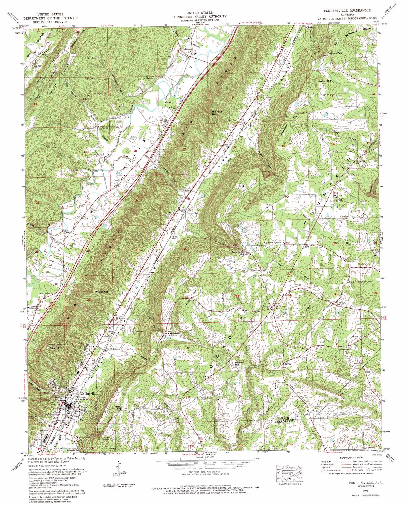
Portersville Topo Map Alabama
To zoom in, hover over the map of Portersville
USGS Topo Quad 34085c7 - 1:24,000 scale
| Topo Map Name: | Portersville |
| USGS Topo Quad ID: | 34085c7 |
| Print Size: | ca. 21 1/4" wide x 27" high |
| Southeast Coordinates: | 34.25° N latitude / 85.75° W longitude |
| Map Center Coordinates: | 34.3125° N latitude / 85.8125° W longitude |
| U.S. State: | AL |
| Filename: | o34085c7.jpg |
| Download Map JPG Image: | Portersville topo map 1:24,000 scale |
| Map Type: | Topographic |
| Topo Series: | 7.5´ |
| Map Scale: | 1:24,000 |
| Source of Map Images: | United States Geological Survey (USGS) |
| Alternate Map Versions: |
Portersville AL 1946, updated 1958 Download PDF Buy paper map Portersville AL 1946, updated 1974 Download PDF Buy paper map Portersville AL 1947, updated 1947 Download PDF Buy paper map Portersville AL 1975, updated 1977 Download PDF Buy paper map Portersville AL 1975, updated 1989 Download PDF Buy paper map Portersville AL 2011 Download PDF Buy paper map Portersville AL 2014 Download PDF Buy paper map |
1:24,000 Topo Quads surrounding Portersville
Langston |
Dutton |
Sylvania |
Dugout Valley |
Valley Head |
Grove Oak |
Fyffe |
Chavies |
Fort Payne |
Jamestown |
Painter |
Crossville |
Portersville |
Little River |
Gaylesville |
Rodentown |
Keener |
Leesburg |
Centre |
Cedar Bluff |
Gadsden West |
Gadsden East |
Ballplay |
Weisner Mountain |
Ellisville |
> Back to 34085a1 at 1:100,000 scale
> Back to 34084a1 at 1:250,000 scale
> Back to U.S. Topo Maps home
Portersville topo map: Gazetteer
Portersville: Basins
The Funnel elevation 293m 961′Portersville: Gaps
Collbran Gap elevation 433m 1420′Dawson Gap elevation 255m 836′
Halls Gap elevation 411m 1348′
Lackey Gap elevation 368m 1207′
Mill Road Gap elevation 301m 987′
Morgan Gap elevation 345m 1131′
Portersville Gap elevation 262m 859′
Portersville Gap elevation 387m 1269′
Wesson Gap elevation 336m 1102′
Portersville: Lakes
Dry Pond elevation 278m 912′Portersville: Pillars
Big Rock elevation 366m 1200′Portersville: Populated Places
Clyde (historical) elevation 378m 1240′Collinsville elevation 218m 715′
Larimore (historical) elevation 215m 705′
Lebanon elevation 224m 734′
Loveless elevation 400m 1312′
Mount Vernon elevation 397m 1302′
Pine Grove (historical) elevation 394m 1292′
Portersville elevation 234m 767′
Willstown (historical) elevation 227m 744′
Portersville: Post Offices
Collinsville Post Office elevation 216m 708′Portersville: Ridges
Drake Hill elevation 435m 1427′Thompson Hill elevation 453m 1486′
Portersville: Springs
Kerley Spring elevation 245m 803′Reed Spring elevation 219m 718′
Portersville: Streams
Dry Creek elevation 324m 1062′Horton Branch elevation 223m 731′
Indian Creek elevation 321m 1053′
Mush Creek elevation 213m 698′
Parrish Branch elevation 213m 698′
Shady Grove Branch elevation 334m 1095′
Stapp Creek elevation 369m 1210′
Portersville: Summits
Mitchell Hill elevation 372m 1220′Paley Hill elevation 354m 1161′
Wooten Hill elevation 477m 1564′
Portersville: Valleys
Campground Hollow elevation 217m 711′Clayton Cove elevation 257m 843′
Ginbelt Hollow elevation 218m 715′
Lackey Cove elevation 240m 787′
Lykes Cove elevation 229m 751′
Straight Hollow elevation 365m 1197′
Portersville digital topo map on disk
Buy this Portersville topo map showing relief, roads, GPS coordinates and other geographical features, as a high-resolution digital map file on DVD: