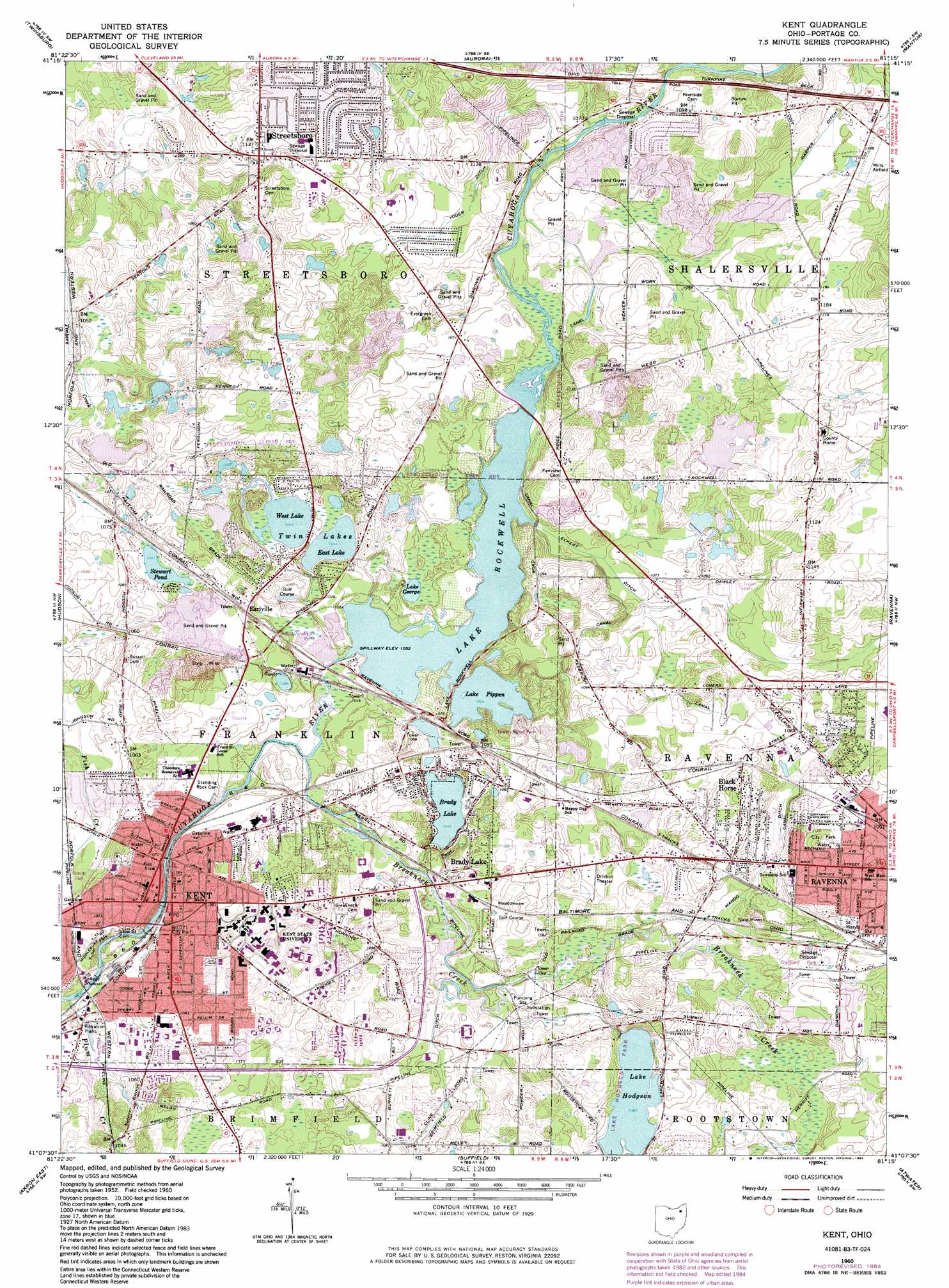
Kent Topo Map Ohio
To zoom in, hover over the map of Kent
USGS Topo Quad 41081b3 - 1:24,000 scale
| Topo Map Name: | Kent |
| USGS Topo Quad ID: | 41081b3 |
| Print Size: | ca. 21 1/4" wide x 27" high |
| Southeast Coordinates: | 41.125° N latitude / 81.25° W longitude |
| Map Center Coordinates: | 41.1875° N latitude / 81.3125° W longitude |
| U.S. State: | OH |
| Filename: | o41081b3.jpg |
| Download Map JPG Image: | Kent topo map 1:24,000 scale |
| Map Type: | Topographic |
| Topo Series: | 7.5´ |
| Map Scale: | 1:24,000 |
| Source of Map Images: | United States Geological Survey (USGS) |
| Alternate Map Versions: |
Kent OH 1960, updated 1961 Download PDF Buy paper map Kent OH 1960, updated 1964 Download PDF Buy paper map Kent OH 1960, updated 1971 Download PDF Buy paper map Kent OH 1960, updated 1980 Download PDF Buy paper map Kent OH 1960, updated 1984 Download PDF Buy paper map Kent OH 1994, updated 1997 Download PDF Buy paper map Kent OH 2010 Download PDF Buy paper map Kent OH 2013 Download PDF Buy paper map Kent OH 2016 Download PDF Buy paper map |
1:24,000 Topo Quads surrounding Kent
Shaker Heights |
Chagrin Falls |
South Russell |
Burton |
Middlefield |
Northfield |
Twinsburg |
Aurora |
Mantua |
Garrettsville |
Peninsula |
Hudson |
Kent |
Ravenna |
Windham |
Akron West |
Akron East |
Suffield |
Atwater |
Deerfield |
Canal Fulton |
North Canton |
Hartville |
Limaville |
Alliance |
> Back to 41081a1 at 1:100,000 scale
> Back to 41080a1 at 1:250,000 scale
> Back to U.S. Topo Maps home
Kent topo map: Gazetteer
Kent: Airports
Mills Airport elevation 337m 1105′ODOT District 4 Office Heliport elevation 330m 1082′
Portage County Airport elevation 366m 1200′
Stoneys Airport elevation 332m 1089′
Kent: Canals
Brimfield Ditch elevation 322m 1056′Eckert Ditch elevation 326m 1069′
Harper Ditch elevation 334m 1095′
Wahoo Ditch elevation 326m 1069′
Yoder Ditch elevation 338m 1108′
Kent: Dams
Gressard Lake Dam elevation 315m 1033′Lake Rockwell Dam elevation 324m 1062′
Muddy Lake Dam elevation 331m 1085′
Pittman Lake Dam elevation 331m 1085′
Kent: Lakes
Brady Lake elevation 321m 1053′East Lake elevation 318m 1043′
Lake George elevation 317m 1040′
Lake Hodgson elevation 331m 1085′
Lake Pippen elevation 320m 1049′
Stewart Pond elevation 320m 1049′
Twin Lakes elevation 319m 1046′
West Lake elevation 317m 1040′
Kent: Parks
Diamond Park elevation 331m 1085′Frame Bog-J Arthur Herrick Nature Preserve elevation 312m 1023′
Fuller Park elevation 308m 1010′
Lake Hodgson Park elevation 338m 1108′
May 4 Memorial elevation 353m 1158′
Plum Creek Park elevation 314m 1030′
Ravenna City Park of Dreams elevation 346m 1135′
Smith Park elevation 315m 1033′
Tom S Cooperrider-Kent Bog State Nature Preserve elevation 341m 1118′
Towers Wood Park elevation 329m 1079′
West Main Street Historic District elevation 334m 1095′
Kent: Populated Places
Birchwood Manor elevation 330m 1082′Black Horse elevation 329m 1079′
Brady Lake elevation 328m 1076′
Doolittles Corners elevation 327m 1072′
Earlville elevation 329m 1079′
Freedom Dam elevation 334m 1095′
Kent elevation 325m 1066′
Kent Mobile Home Park elevation 343m 1125′
Lakeside Terrace elevation 313m 1026′
M And M Mobile Home Park elevation 326m 1069′
Pine Gate Village elevation 326m 1069′
Pine Manor elevation 335m 1099′
Sprotts Corners elevation 331m 1085′
Streetsboro elevation 345m 1131′
Sugar Bush Knolls elevation 334m 1095′
Summit Mobile Home Park elevation 328m 1076′
Twin Lakes elevation 324m 1062′
Village Estate Mobile Home Park elevation 325m 1066′
West Park Homes elevation 326m 1069′
Kent: Post Offices
Earlville Post Office (historical) elevation 329m 1079′Kent Post Office elevation 322m 1056′
Kent Post Office elevation 324m 1062′
Streetsboro Post Office (historical) elevation 344m 1128′
Kent: Reservoirs
Frame Lake elevation 312m 1023′Gressard Lake elevation 315m 1033′
Lake Rockwell elevation 324m 1062′
Muddy Lake elevation 331m 1085′
Pittman Lake elevation 331m 1085′
Kent: Streams
Breakneck Creek elevation 313m 1026′Plum Creek elevation 308m 1010′
Kent: Summits
Nash Hill elevation 353m 1158′Kent digital topo map on disk
Buy this Kent topo map showing relief, roads, GPS coordinates and other geographical features, as a high-resolution digital map file on DVD:
 map DVD")