Carlton Lake Topo Map Montana
To zoom in, hover over the map of Carlton Lake
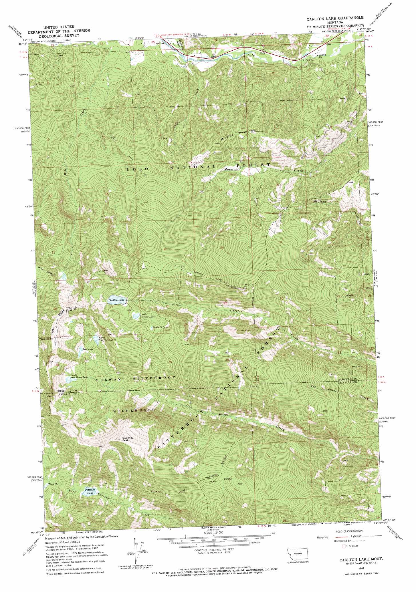
USGS Topo Quad 46114f2 - 1:24,000 scale
| Topo Map Name: | Carlton Lake |
| USGS Topo Quad ID: | 46114f2 |
| Print Size: | ca. 21 1/4" wide x 27" high |
| Southeast Coordinates: | 46.625° N latitude / 114.125° W longitude |
| Map Center Coordinates: | 46.6875° N latitude / 114.1875° W longitude |
| U.S. State: | MT |
| Filename: | o46114f2.jpg |
| Download Map JPG Image: | Carlton Lake topo map 1:24,000 scale |
| Map Type: | Topographic |
| Topo Series: | 7.5´ |
| Map Scale: | 1:24,000 |
| Source of Map Images: | United States Geological Survey (USGS) |
| Alternate Map Versions: |
Carlton Lake MT 1967, updated 1972 Download PDF Buy paper map Carlton Lake MT 1998, updated 2002 Download PDF Buy paper map Carlton Lake MT 2011 Download PDF Buy paper map Carlton Lake MT 2014 Download PDF Buy paper map |
| FStopo: | US Forest Service topo Carlton Lake is available: Download FStopo PDF Download FStopo TIF |
1:24,000 Topo Quads surrounding Carlton Lake
Petty Mountain |
Diamond Point |
Primrose |
Northwest Missoula |
Northeast Missoula |
Garden Point |
Camp Creek |
Blue Mountain |
Southwest Missoula |
Southeast Missoula |
West Fork Butte |
Dick Creek |
Carlton Lake |
Florence |
Davis Point |
Ranger Peak |
Saint Joseph Peak |
Saint Mary Peak |
Stevensville |
Grayhorse Creek |
White Sand Lake |
Gash Point |
Victor |
Bing |
Corley Gulch |
> Back to 46114e1 at 1:100,000 scale
> Back to 46114a1 at 1:250,000 scale
> Back to U.S. Topo Maps home
Carlton Lake topo map: Gazetteer
Carlton Lake: Dams
Carlton Lake Number 1 Dam elevation 2379m 7805′Carlton Lake: Lakes
Carlton Lake elevation 2379m 7805′Little Carlton Lake elevation 2362m 7749′
McClain Lake elevation 2364m 7755′
North One Horse Lake elevation 2396m 7860′
Peterson Lake elevation 1982m 6502′
Reed Lake elevation 2408m 7900′
South One Horse Lake elevation 2266m 7434′
Carlton Lake: Mines
Mill Creek Mine elevation 1502m 4927′Carlton Lake: Streams
John Creek elevation 1033m 3389′Carlton Lake: Summits
Lolo Peak elevation 2786m 9140′Mormon Peak elevation 1843m 6046′
Sweeney Peak elevation 2795m 9169′
Carlton Lake: Trails
Carlton Lake Trail elevation 2488m 8162′Mill Creek Trail elevation 1761m 5777′
Sweeney Ridge Trail elevation 2201m 7221′
Carlton Lake: Valleys
Chickaman Gulch elevation 1031m 3382′Hollensteiner Gulch elevation 1034m 3392′
Carlton Lake digital topo map on disk
Buy this Carlton Lake topo map showing relief, roads, GPS coordinates and other geographical features, as a high-resolution digital map file on DVD: