Hopewell Junction Topo Map New York
To zoom in, hover over the map of Hopewell Junction
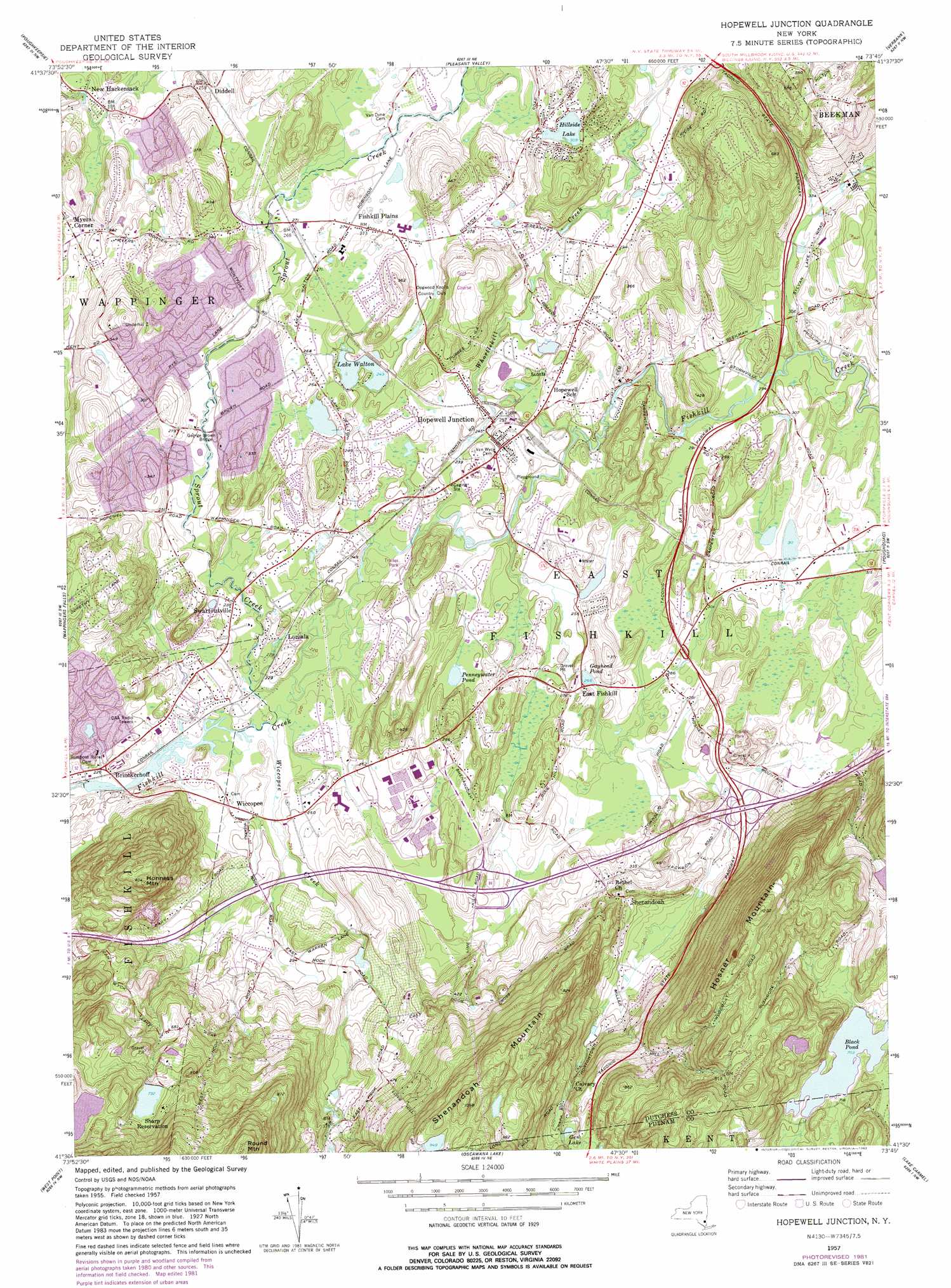
USGS Topo Quad 41073e7 - 1:24,000 scale
| Topo Map Name: | Hopewell Junction |
| USGS Topo Quad ID: | 41073e7 |
| Print Size: | ca. 21 1/4" wide x 27" high |
| Southeast Coordinates: | 41.5° N latitude / 73.75° W longitude |
| Map Center Coordinates: | 41.5625° N latitude / 73.8125° W longitude |
| U.S. State: | NY |
| Filename: | o41073e7.jpg |
| Download Map JPG Image: | Hopewell Junction topo map 1:24,000 scale |
| Map Type: | Topographic |
| Topo Series: | 7.5´ |
| Map Scale: | 1:24,000 |
| Source of Map Images: | United States Geological Survey (USGS) |
| Alternate Map Versions: |
Hopewell Junction NY 1957, updated 1959 Download PDF Buy paper map Hopewell Junction NY 1957, updated 1963 Download PDF Buy paper map Hopewell Junction NY 1957, updated 1973 Download PDF Buy paper map Hopewell Junction NY 1981, updated 1982 Download PDF Buy paper map Hopewell Junction NY 2010 Download PDF Buy paper map Hopewell Junction NY 2013 Download PDF Buy paper map Hopewell Junction NY 2016 Download PDF Buy paper map |
1:24,000 Topo Quads surrounding Hopewell Junction
Rosendale |
Hyde Park |
Salt Point |
Millbrook |
Amenia |
Clintondale |
Poughkeepsie |
Pleasant Valley |
Verbank |
Dover Plains |
Newburgh |
Wappingers Falls |
Hopewell Junction |
Poughquag |
Pawling |
Cornwall |
West Point |
Oscawana Lake |
Lake Carmel |
Brewster |
Popolopen Lake |
Peekskill |
Mohegan Lake |
Croton Falls |
Peach Lake |
> Back to 41073e1 at 1:100,000 scale
> Back to 41072a1 at 1:250,000 scale
> Back to U.S. Topo Maps home
Hopewell Junction topo map: Gazetteer
Hopewell Junction: Airports
IBM East Fishkill Heliport elevation 101m 331′IBM Fishkill Plant Number 2 Heliport elevation 76m 249′
Mid-Hudson Helicopter Service Heliport elevation 82m 269′
Hopewell Junction: Bridges
George Brown Bridge elevation 70m 229′Hopewell Junction: Lakes
Black Pond elevation 214m 702′Gayhead Pond elevation 81m 265′
Gem Lake elevation 104m 341′
Hillside Lake elevation 94m 308′
Lake Walton elevation 74m 242′
Penneywater Pond elevation 74m 242′
Hopewell Junction: Parks
Douglas Phillips Park elevation 66m 216′Hopewell Junction: Populated Places
Brinckerhoff elevation 67m 219′Charlotte Grove Mobile Court elevation 77m 252′
Diddell elevation 76m 249′
East Fishkill elevation 84m 275′
Fishkill Plains elevation 83m 272′
Hillside Lake elevation 114m 374′
Hopewell Junction elevation 75m 246′
Lomala elevation 68m 223′
Moorgate Mobile Home Park elevation 77m 252′
Myers Corner elevation 66m 216′
New Hackensack elevation 53m 173′
Roberts Mobile Home Park elevation 78m 255′
Shenandoah elevation 114m 374′
Swartoutville elevation 70m 229′
Wiccopee elevation 72m 236′
Hopewell Junction: Reservoirs
Sharp Reservation elevation 223m 731′Hopewell Junction: Streams
Sprout Creek elevation 66m 216′Whortlekill Creek elevation 67m 219′
Wiccopee Creek elevation 65m 213′
Hopewell Junction: Summits
Honness Mountain elevation 276m 905′Hosner Mountain elevation 366m 1200′
Round Mountain elevation 380m 1246′
Shenandoah Mountain elevation 334m 1095′
Hopewell Junction digital topo map on disk
Buy this Hopewell Junction topo map showing relief, roads, GPS coordinates and other geographical features, as a high-resolution digital map file on DVD:
New York, Vermont, Connecticut & Western Massachusetts
Buy digital topo maps: New York, Vermont, Connecticut & Western Massachusetts